-
-
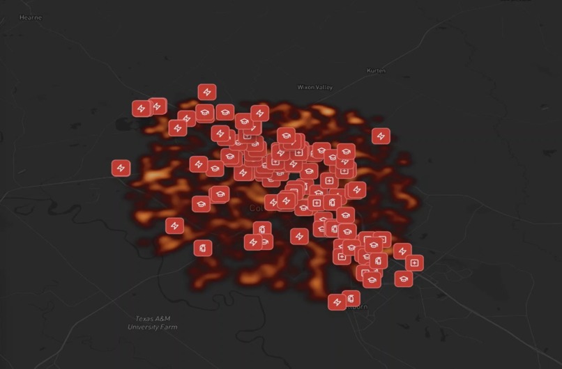
Map showing locations vulnerable to fire spread.

Cinder Control 🔥🌲
Inspiration
When I was in California when I was little, wildfires were pretty prevalent. I wasn't too aware of what caused them or how they spread, but it feels like every year I've heard another tale of a wildfire demolishing entire cities - and in some cases people aren't even aware they are coming. My hope is that with Cinder Control knowledge and awareness of Wildfires, as well as responding to them, becomes a more intuitive and easy to access process.
What it does
Cinder Control is a dashboard that allows accurate tracking and predictions of how a fire will spread across a certain area, what landmarks will be affected by it, and several tools to help first responders, firefighters, and those in the line of fire help understand what they can do.
Users are able to set environmental parameters through the dashboard, or through voice. The layout is also mobile friendly for anyone who may need it on the go.
Using a Python Cellular Automata Simulation, it predicts the spread of wildfire over windows of up to 96 hours.
The systems figure out what infrastructure nearby will be "ingested" by the fire, and create warnings of the estimated time that will happen.
The system can help plan routes between these points to help evacuation or first responder efforts.
How we built it
The main webapp was built on a Next.js framework, using React and Typescript. Gemini was leveraged to create some of the stylistic choices for the UI.
The backend consists of a FastAPI endpoint runnin with Python, as well as OpenAI to parse natural language input. Python also used a parallelized cellular automata model, basically creating cells for the fire to spread using certain conditions.
Responses are created with OpenAI as well with ElevenLabs narration.
Additional APIs leveraged were Mapbox, Overpass OpenStreetMap, and NOAA NWS.
Challenges we ran into
Intent Collision: The AI at the beginning was not able to tell when the user wanted to simulate a fire, versus when a user wanted to pull from the alert list of an already simulated fire.

GIS Lag: While this would be fixed on a HPC system as well, the strain of loading so many points into the map whenever a location was chosen had to be done carefully in order to ensure the site did not crash.

Map Api: The MapBox API turned out to be rather hard to actually create a map with when I first started, but once working it surpassed expectations heavily.
Accomplishments that we're proud of
I'm super proud of achieving what I wanted to with this project. I had a lot of goals from the start and thought it may be unreasonable to fit all of them, but I think I got pretty much everything I had originally planned. This is also my first time working with a map type of project, and it was very rewarding to figure out how to use it.
What we learned
I learned a lot about utilizing a bunch of different APIs I never tried before, including, NOAA, MapBox, and Overpass. On top of this I feel like I better understand how to make apps that might leverage the use of HPC in the future, whether for the general population, or more business use.
What's next for Cinder Control
Cinder control can offer a lot more. To start actual tracking current wildfires would be a nice addition, instead of having to manually put in the variables yourself. On top of that Cinder Control might not even have to be specifically about Wildfires. Environmental hazards of multiple scales can - for the most part - be predicted to some degree of accuracy. Even something simple like having a factory built near someone's house could create smog that moves towards their area. Being able to map several different types of predictable outcomes may help residents be able to plan for several disasters, not just fires.
Built With
- elevenlabs
- fastapi
- gemini
- mapbox
- next.js
- noaa
- openai
- overpass-openstreetmap
- python
- react
- tailwind


Log in or sign up for Devpost to join the conversation.