-
-
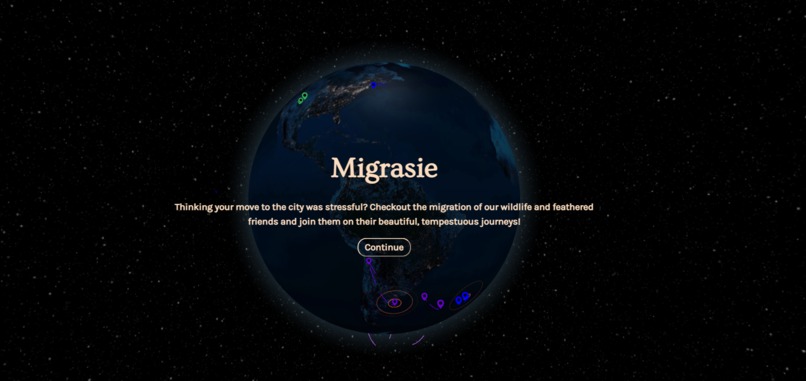
Homepage of the application
-
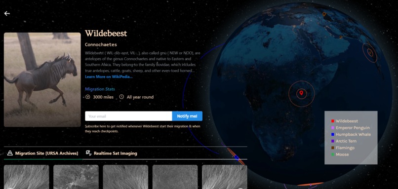
Informative view on clicking any location pin
-
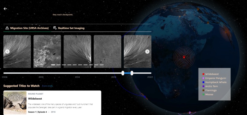
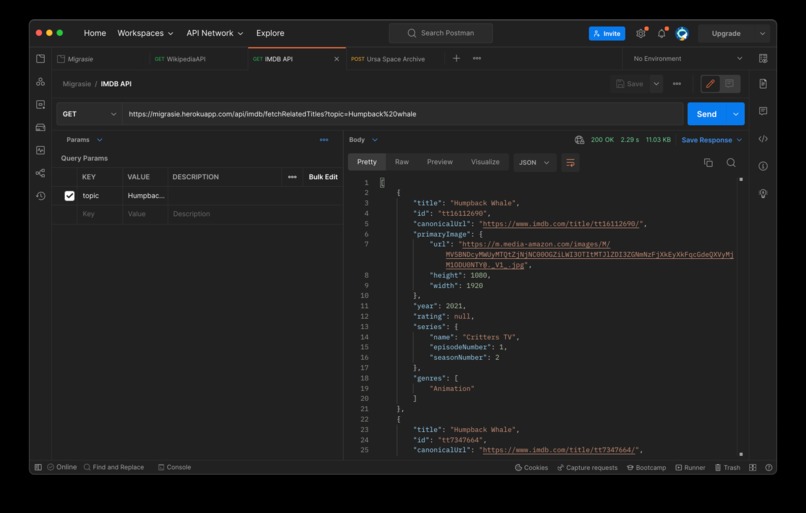
Documentary/Multi-media content pulled from IMDB
-
-
-


Inspiration 🌱
A couple of months ago, we worked on a hackathon that contributed directly to the conservation of chimpanzees in Africa. Inspired by the fact that technology can be used to spread awareness as well as improve the lives of species with whom we share the planet; we were once again inspired to work on a similar theme of animal conservation.
Migration of species, as defined by britannica is — migration, in ethology, the regular, usually seasonal, movement of all or part of an animal population to and from a given area.
This phenomenon is fascinating on many levels, we are talking about huge herds of animals travelling several thousand miles every year in a given time period. Animals have been doing this for hundreds of years.
Using URSA’s satellite imagery API, we wanted to capture this beauty for a few species around the globe and present it in an easy to consume format.
Here we present to you — Migrasie, which is Afrikaans for migration.
What it does ⚙️
Migrasie is an interactive visualisation tool that helps children, students or curious adults understand the migration of various species that take place on our planet.
They can watch the beauty unfold before their eyes and also learn more about these migratory routes.
Users can view the migration sites of animals from space, they can also subscribe to the migrations of their choice, for example; The Arctic Tern, to get notified when they start, complete or reach certain checkpoints of interest. You may also place an order to shoot certain points of interest via satellites on request.
How we built it 🛠️
Our philosophy is to keep it simple and straightforward. 📝
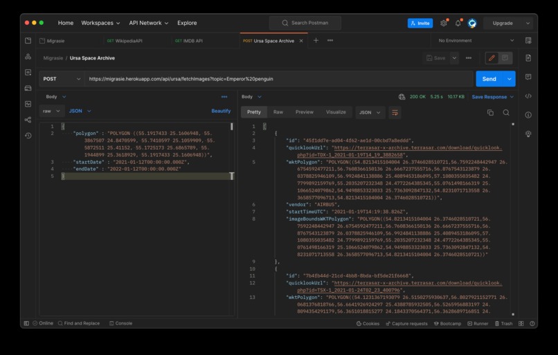
We decided to use URSA archives to power our database of images since the images are captured using SAR technology. Using SAR, two-dimensional images of 3-D objects can be obtained, it also provides finer resolution than conventional radars. Since we wanted Migrasia to also enable researchers, we decided to utilise URSA APIs for images.
Additionally, IMDB’s graphql APIs provided a unique way to suggest users of our application appropriate documentaries based on the animal that they’ve clicked on.
We decided that the best way to depict migration routes along with URSA’s REST APIs and IMDB’s graphql APIs is to visually represent it on an interactive globe.
We used ThreeJS to render a Globe representing the Earth on-screen and plotted coordinates on the map to depict migration routes of different kinds of animals.
Challenges we ran into 🚧
- Rendering a Globe using ThreeJS was a herculean task for us. This was our first brush with ThreeJS, for a while we wondered if we’d bitten more than we could chew, but we managed to get it up and running in time for the submission! 😅
- We had to learn a great deal about ThreeJS from scratch to implement the zoom function on our location pin markers on the globe — figuring this out was one of the highlights of our hackathon experience 😀 .
- Learning how to animate the movement of the globe was a real challenge as well. We had very few resources at our disposal and it was a significant obstacle that we had to overcome 💡.
- Collecting accurate data about migrating animals & locations around world without prior experience
Accomplishments that we're proud of 🏆
- We are extremely excited (and proud!) to submit our first full-fledged 3D project despite many roadblocks along the way! 😆
- Learning how to use and tweak Tweenjs for this hackathon is a big win for us. 😏
- We’re extremely happy about the ADX APIs we chose and how we implemented the theme in our application.😌
- Working with GraphQL end points of URSA and IMDB to get required data in desired format
What we learned 📚
- Learned a great deal about animal migration and their routes through the globe.
- Understood SAR - Synthetic aperture radar - imaging technology and its importance in research.
- Learned how to effectively integrate with AWS Data Exchange service.
- Learned to use ThreeJS along with TweenJS for rendering and animating 3D objects on modern browsers.
What's next for Migrasie 🚀
Thanks to tracking technology these days scientists and researchers are able to track the path of these migratory animals. For example, they tracked the path of this leatherback sea turtle that travelled more than 12,000 miles.
However as we are all aware due to climate changes, temperatures are rising in many parts of the world. Animals rely on these cues in the environment such as changes in temperature or seasons to begin their migratory journeys. Additionally movement of humans and man-made infrastructure can interfere with the migratory paths of these animals.
We want Migrasie to serve as a tool that helps scientists and researchers track the movement of these animals and to study patterns. In case of any changes or drops in animal population, they can flag it through an alert system and understand what changed around the animal ecosystem.
Possible use-cases that can be implemented:
- Integration with Ursa's New Tasking and Ordering API to support on-demand geojson capturing 🛰️
- Plan government infrastructure projects without affecting the ecology 🌲
- Enable scientists and researchers to track movement of animals 👩🔬
- Create alert mechanisms to identify changes in animal routes or population numbers 🐗
Built With
- amazon-web-services
- aws-data-exchange
- create.js
- express.js
- globe.gl
- heroku
- imdb-api
- lodash
- mantine
- node.js
- react
- supabase
- three.js
- tween.js
- ursa-space


Log in or sign up for Devpost to join the conversation.