-
-
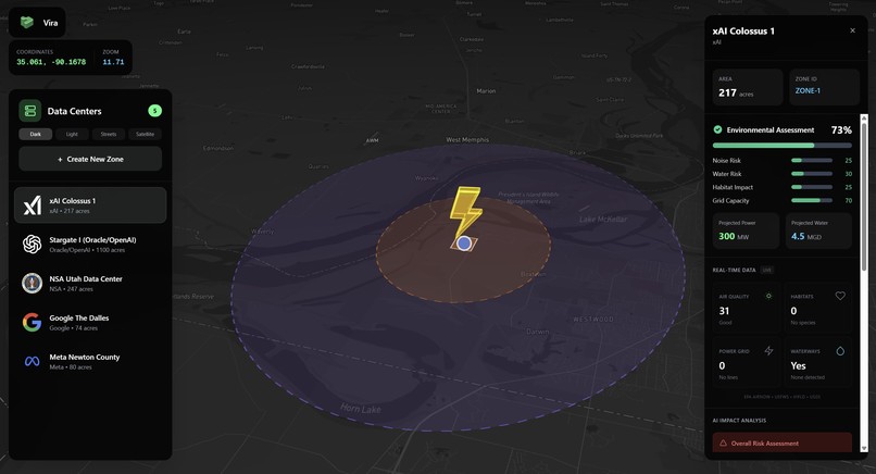
Example Datacenter
-
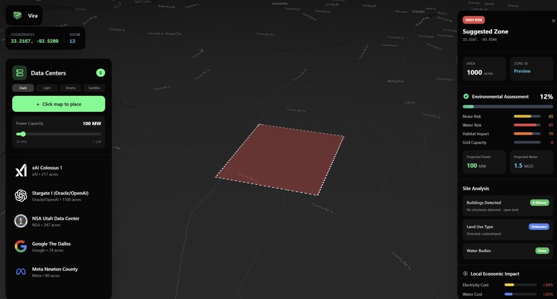
Custom datacenter placement


Inspiration
Data centers are the physical backbone of the digital world, yet decisions about where to build them are often made with limited visibility into environmental and community impacts. As energy demand from AI and cloud computing grows rapidly, we wanted to explore how modern mapping and AI tools could help planners make more sustainable, informed infrastructure decisions.
What it does
Vira is an interactive, map-based decision support tool that helps evaluate the environmental suitability of potential data center sites. Users can:
- Select a region and choose a data center scale (small, medium, or hyperscale)
- Click eligible areas on the map to analyze potential sites
- View an overall sustainability risk score
- Explore detailed breakdowns for:
- Air quality (PM2.5)
- Water stress and proximity
- Population density
- Ecological sensitivity An AI assistant explains the results in natural language, and optional voice summaries provide accessible spoken briefings.
How we built it
Mapbox GL JS powers the interactive map and spatial queries. OpenAQ provides government-grade PM2.5 air quality data. Open-Meteo supplies weather and climate context (rainfall, heat, wind). We use MongoDB to store all the data for the datacenters. Environmental and land-use layers define baseline buildable zones. A custom scoring model aggregates multiple risk factors into a single sustainability score. Google Gemini generates human-readable explanations of environmental tradeoffs. All data is visualized in real time, with live feedback as users change site parameters.
Challenges we ran into
No universal zoning API: Construction and zoning data varies by region, so we built our own “baseline suitability mask” using environmental and land-use constraints. Integrating multiple APIs: Ensuring consistent spatial resolution and performance across datasets was non-trivial.
Accomplishments that we're proud of
We built a product that makes complex environmental risk understandable, actionable, and accessible using AI and geospatial technology. Companies and government planners could use this to determine where and how to build data centers in the most environmentally friendly and sustainable way.
What we learned
We learned how to combine AI reasoning with geospatial data to turn complex environmental signals into clear, actionable insights. We also learned the importance of framing sustainability tools as decision support systems rather than trying to overclaim precision or replace real-world policy.
What's next for Vira
Next, we want to expand Vira with more regional datasets, including grid carbon intensity, zoning layers, and long-term climate scenarios. We also plan to add scenario simulations and real project inputs so stakeholders can evaluate sustainable infrastructure decisions at scale.


Log in or sign up for Devpost to join the conversation.