-
-
TransitLens Logo
-

Demo of TransitLens at Glasgow Subway's Buchanan Street station
-
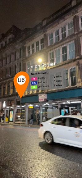
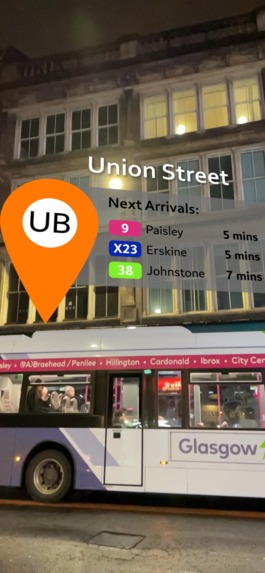
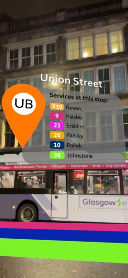
Demo showing an arrival board of a bus stop in AR view
-
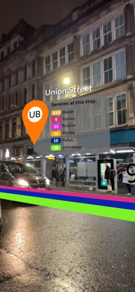
View of services available at the specific stop, along with coloured lines of each service.
-
Close up of an arrival board of a bus stop in AR view.
-
Close up of a list of services available at the bus stop in AR view.
-
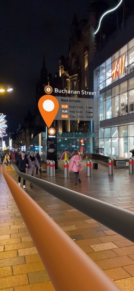
Demo showing underground subway lines, with arrivals board for the station
-
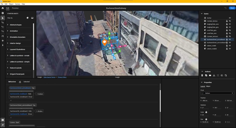
Development view inside Adobe Aero
-
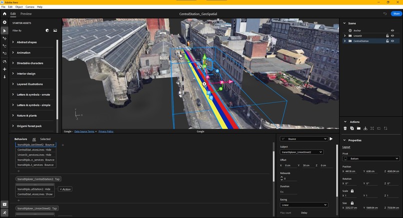
Another development view inside Adobe Aero
-
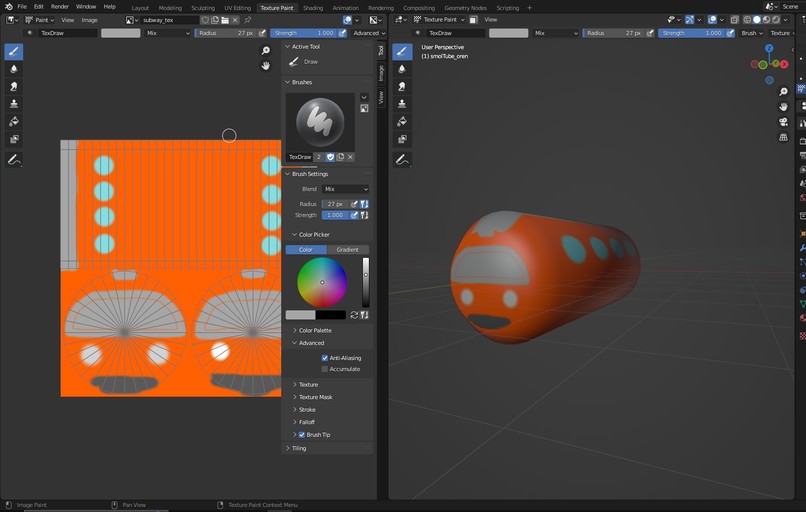
Cute subway 3D model in the making!
-
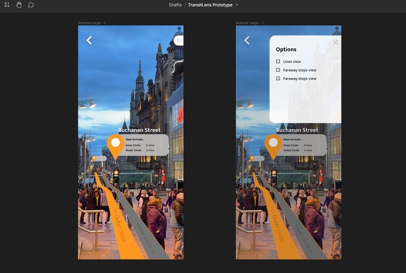
Initial prototyping in Figma


Inspiration 🌟
My main inspiration comes from using Google Maps itself! Usually when using Google Maps for walking directions, you could get a 'Live View' which is basically an AR-powered guide for your walking directions which I think it's really cool and definitely will be the future when AR glasses arrives. I then take the idea further and implement to the scope of my idea, which is to implement a wayfinding for transit stops in AR space.
The idea is also inspired by my personal experiences of taking buses across the UK where at some places, multiple bus stops are placed close to each other in one street yet they serve different bus lines/numbers, and waiting at the wrong bus stop (sometimes at the other side of the street!) can be very frustrating when you have to rush and catch the bus.
As for the case of metro stations, you would've wanted to know where the line goes before you get in so you can be sure of the direction you're going to with the visualization provided by TransitLens. On top of that, future implementations could include wayfindings to find the entrances of the station.
What it does? 🤔
At its very base of the experience, TransitLens users can view and identify their nearest transit stops be it bus stop, train stations and others. The users can also see what services or lines that are available at that stop, and see the departure board of that stop where they can view the next arrivals as well as status info for the services on that stop.
TransitLens users can also view the coloured 'lines' of the services that are available and the direction it goes. While this might not always be useful for bus stops (like it's almost always red in London), it will be useful for metro stations info.
How I built it 🛠
At the moment, the TransitLens experience is built using Adobe Aero with Google's Geospatial Creator powering the geospatial tracking behind it. It simply uses 2D images to visualize the transit stop info and the lines on the transit stops and uses Adobe Aero's built-in behaviour builder capabilities to make simple animations and interaction without using any code.
Challenges I ran into 💪
Problems with Unity:
Initially, this project was to be built with Unity as it would have provided me with a lot of customizations and features that I can implement for TransitLens. However, due to limitations of my equipment where I am using an old Macbook that does not support compilation for my latest iPhone, I was not able to test my project in the first place. I did try to build it for Android devices, however due to the most recent update of the ARCore extensions which caused a lot of error during initial testing and a lot of other setbacks during setup, I decided to drop using Unity as time runs short for this hackathon.
There were also problems with the ARCore extensions' latest API version itself when trying to build with Android where when building with Unity v2022 will produce a black screen without initializing the Geospatial features. Although others have reported to be able to build with v2021, I did not succeed and this was the final nail in the coffin that made me drop Unity for this hackathon.
Location tracking with Adobe Aero:
Apart from that, it seems that Adobe Aero relies of VPS only to set its geospatial anchos and no GPS location tracking is used, so there were accuracy issues when testing and viewing the experience. Also, Adobe Aero does not have robust capabilities as much as what Unity can provide. I was planning to include more advanced features such as implementing external APIs but this could not be done.
Accomplishments that I'm proud of 🏅
Despite all the setbacks and headache starting with Unity and dropping it midway, I am proud to be able to implement the idea within limitations of Adobe Aero. Along the way, I was also able to learn Unity and experience on how figure out all the erros despite not being able to build on it. Last but not least, I am sooo excited to be able to use the Geospatial API and can finally use real geolocation tracking for AR experiences finally! It has been long time coming for myself as a long-time AR creator!
What I learned 📝
I am glad that I was able to learn great deal about Unity as it was my first time using it, and resolving all the errors I came by was such an experience despite not building on it after all.
It is also interesting that Adobe Aero uses solely VPS to track their geospatial anchor for their AR experiences, and this led me to conclude that geospatial experiences built with Adobe Aero are much better for places or buildings with recognizable features rather than a normal street as this can result in better tracking accuracy.
Halfway through the project, I figured that this project might be better to be built as a Photorealistic 3D Tiles project ratehr than AR for easier deployment and better context of the experience with the aerial view of P3DT, especially when you take a look at this example on LinkedIn! However, I still believe there is a case for AR wayfinding with this project. And it's much cooler isn't it?
What's next for TransitLens🔎? 🏃♂️
After this hackathon, I am looking forward to extend my idea and properly build TransitLens in Unity so I could implement more advanced features such as view options, search function for the stops, real-time navigation, real-time tracking of vehicles using external APIs and many more. This will pretty much be quite far in the future as I lack the resources and time to extend it at the moment, but I won't give up!
As bold as it may seem, I might want to pitch my idea to transport companies so they could possibly implement this experience in their own mobile app and I hope this could improve their user's experience using public transport.
A more far-fetched idea is to see this feature implemented within Google Maps itself as I've seen many implementations of 'Live View' navigations within Google Maps. Getting walking directions is available in Live view, and recently I've seen an AR navigation guide for inside airport terminals, I'd reckon implementing wayfinding for public transport stops would also be possible.
Footer notes:
Here are some contexts of where the links below will take you!
- Figma link to my UI prototype in Figma!
- Adobe Aero link for Buchanan Street Subway Station
- Adobe Aero link for bus stops along Union Street, Glasgow
Built With
- adobe-aero
- adobeaero
- arcore
- geospatialcreator
- google-geospatial-creator
- googlegeospatialcreator
- unity


Log in or sign up for Devpost to join the conversation.