Log inSign up
USGS Water Resources
US Department of the Interior
5,450 posts
Image
user avatar
USGS Water Resources
US Department of the Interior
@USGS_Water
Observing, understanding, predicting, delivering #WaterScience 💧Comment policy: usgs.gov/comments 💧Posts do not=endorsements on.doi.gov/pgwu0Y
usgs.gov/mission-areas/…
Joined April 2016
60
Following
7,923
Followers
  • user avatar
    USGS Water Resources
    US Department of the Interior
    @USGS_Water
    Jun 19
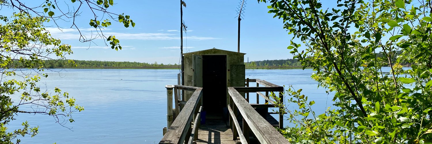
    100+ years of water data. One iconic location 📍📈 Located at the gateway to the Grand Canyon, the Colorado River at Lees Ferry is where recreation meets resource management and vital aquatic science. In 1921, the USGS established a streamgage at this location to monitor the
    he Colorado River at Lees Ferry. The Lees Ferry streamgage is visible at the base of the cliffs on the left sides of the photo. Photo by the USGS
    AZWSC staff, Sarah Shepherd and Kat Cooney, collect a discrete water-quality sample for NWQN.
    Hydrologic technician, Janice Talley, services the continuous water-quality buoy.
    Hydrologic technician, Decker Mcelroy, collects discharge data using an ADCP.
    479
  • user avatar
    USGS Water Resources
    US Department of the Interior
    @USGS_Water
    Jun 17
    Dirt detectives 🔎 Per- and polyfluoroalkyl substances (PFAS), manmade contaminants associated with public health concerns, have been found in shallow soils throughout northern New England, according to a new USGS study. Looking to define where and how much PFAS may be
    USGS staff take a soil sample from a collection site in New Hampshire. The shallow soils were collected as part of a statewide monitoring effort to identify the prevalence of "background" PFAS in the environment.
    173
  • user avatar
    USGS Water Resources
    US Department of the Interior
    @USGS_Water
    Jun 16
    Thinking of trading your screen time for stream time? Don’t forget to "pack" your data! 🚣🌊 The USGS operates a network of more than 13,000 streamgages nationwide. Whether you’re looking for the perfect rapids or a peaceful float, our real-time data tells you if conditions
    A group of people wearing helmets and life jackets paddle a whitewater raft through a strong current on the Gauley River in West Virginia. In the background, another group of people sits on a large rock, watching the raft navigate the rapids. Photo by Matt Kearns, USGS
    176
  • user avatar
    USGS Water Resources
    US Department of the Interior
    @USGS_Water
    Jun 12
    Happy Great Outdoors Month! We don't just get outside; we get to work. 🏞️ At USGS, fieldwork is where science happens. Our "desks" are often riverbanks and boat decks, where we monitor the pulse of the nation’s waterways. From tracking nutrient levels to maintaining the
    A USGS hydrologic technician holds the level rod during an annual set of levels at the historic Cataloochee Creek near Cataloochee, North Carolina. Photo by Jessica Moore, USGS
    USGS hydrologic technicians log data at Gunpowder Falls at Glencoe, Maryland.
    USGS staff prepare to drop a current meter overboard from the research boat, Muddy Waters, offshore of Wellfleet, Massachusetts.
    USGS staff gather and measure shellfish samples collected at Martinez Harbor, Contra Costa County, California. Photo by California Department of Water Resources
    167
  • user avatar
    USGS Water Resources
    US Department of the Interior
    @USGS_Water
    Jun 11
    USGS investigates per- and polyfluoroalkyl substances (PFAS) in groundwater near New Hampshire Superfund Site. PFAS can be found in a wide range of sources, including man-made items such as stain-resistant textiles, nonstick cookware, industrial chemicals, and food packaging –
    USGS scientists sampling groundwater near the top of the water table in a corn field in Concord, New Hampshire. Photo by Joseph Ayotte, USGS.
    A view of Coakley Landfill in Northampton, NH. Pipes used to vent landfill gases can be seen in the distance. Photo by Philip Harte, USGS.
    Scientists work in the Leetown, WV Eastern Ecological PFAS Lab. Photo by David Fisher, USGS.
    183
  • user avatar
    USGS Water Resources
    US Department of the Interior
    @USGS_Water
    Jun 10
    Pesticides used on farms, roadsides, and other landscapes can wash into rivers and streams, where they may harm aquatic plants, insects, fish, and even human health. A new USGS study analyzed 10,000+ samples from 81 sites (2013–22) to track long‑term trends in 80 pesticides and
    Map from publication showing acute and chronic aquatic life benchmark exceedances at USGS National Water Quality Network riverine sites (2013–2022). Inner circle size shows how many pesticides exceeded acute benchmarks; red outline thickness shows how many exceeded chronic benchmarks. Inner circle color indicates how many acute exceedances occurred (yellow for low, red for more than 150).
    200
  • user avatar
    USGS Water Resources
    US Department of the Interior
    @USGS_Water
    Jun 9
    What happens when high-intensity storms hit a wildfire burn scar? Following the 2022 McKinney Fire in Northern California, a high-intensity storm moved across the burn area. Significant ash and debris runoff into the Klamath River led to a significant drop in dissolved oxygen,
    The Klamath River following the 2022 McKinney Fire, with burned areas visible along the distant ridgeline and a debris fan in the foreground near the confluence of Little Humbug Creek and the Klamath River. The photo documents sediment and debris deposited from burned landscapes into the river corridor following wildfire and storm runoff. Photo by Jennifer Curtis, USGS
    Active fire and fish kill. Photo by the Karuk Tribe
    A post-fire debris flow (PFDF) scar in the headwaters of Vesa Creek. Photo by California Department of Fish and Wildlife
    161
  • user avatar
    USGS Water Resources
    US Department of the Interior
    @USGS_Water
    Jun 8
    The flow of groundwater into oceans might be invisible to the naked eye but can have major impacts on coral reef health. On World Oceans Day, we are highlighting the surprising role that groundwater plays in near-shore ocean ecosystems: 🪸 When groundwater flows into the
    Thermal infrared image of two USGS researchers standing on the coast and looking up over a coastal groundwater plume that is non-visible to the naked eye but is shown in this thermal image from temperature differences between the cooler (blue) groundwater and warmer (pink) ocean water over the coral reefs.
    USGS physical scientist installs a special buoy in the waters of the National Park of American Samoa on Ofu in the Manuʻa Islands Group. The special buoy, developed by USGS scientists, measures radon on the reef, which is a marker of submarine groundwater.
    A healthy coral reef in the Tumon Bay Marine Preserve off Tumon, Guam, showing several different species of fish swimming over a high coral cover reef composed of hard and soft coral species.
    310
  • user avatar
    USGS Water Resources
    US Department of the Interior
    @USGS_Water
    Jun 5
    Something’s blooming in the Big Apple - and it’s not just the flowers. 🔬🏙️ While Central Park is an urban oasis, its lakes often face a recurring summer visitor, Cyanobacterial Harmful Algal Blooms (cyanoHABs). What Are CyanoHABs? 🦠 Also known as blue-green algae,
    USGS staff use an inflatable rowboat to conduct water quality sampling in 6 different lakes of Central Park in New York City during summer 2025. Photos by Rebecca Gorney, USGS
    270
  • user avatar
    USGS Water Resources
    US Department of the Interior
    @USGS_Water
    Jun 4
    May streamflow conditions across the U.S. 💧 In May, wet conditions persisted across much of the Midwest, Northeast, and parts of the central U.S., while dry conditions continued across portions of the Southwest and southern Plains. Notable weather patterns included: 🌧️
    📸: Tile charts showing national streamflow conditions for May 2026 by flow percentiles at USGS streamgages relative to the historic record across the U.S. Flow percentiles are broken up into seven bins from 0-100% where increased percentiles indicate wetter conditions.
    251
  • user avatar
    USGS Water Resources
    US Department of the Interior
    @USGS_Water
    May 29
    Keeping the Great Lakes great starts with the rivers that feed them! 🌊🔬 From the deck of a boat to the rail of a bridge, USGS science is the engine behind a healthier, more resilient Great Lakes ecosystem. The Great Lakes contain over 20% of the world's surface fresh water,
    GLRI large river sampling on the Canadian side of the St. Lawrence River near Morristown, New York, on board the new Research Vessel Osprey. Photo 1 by Andrew Kowalczk, USGS
    GLRI large river sampling on the Canadian side of the St. Lawrence River near Morristown, New York, on board the new Research Vessel Osprey. Photo by Andrew Kirby, USGS
    GLRI large river sampling on the Canadian side of the St. Lawrence River near Morristown, New York, on board the new Research Vessel Osprey. Photo by Andrew Kirby, USGS
    204
  • user avatar
    USGS Water Resources
    US Department of the Interior
    @USGS_Water
    May 28
    “Satellites reveal a new view of Earth’s water from space.” – Surface Water and Ocean Topography Hydrology Lead, Tamlin Pavelsky, NOAA Next-generation satellite observations have fundamentally redefined surface water monitoring by transforming how we track water quality,
    In this image from the NASA-U.S. Geological Survey Landsat 8 satellite, the dark-brown waters of the Suwannee River meet the blue-green Gulf of America along Florida’s Big Bend (where the state’s panhandle curves to meet its peninsula). Credit: @nasa /USGS/A. Alonso
    194
  • user avatar
    USGS Water Resources
    US Department of the Interior
    @USGS_Water
    May 27
    Forty-one percent of Arizona’s water comes from a source you can’t see 💧🌵 The Arizona Groundwater Explorer (AGEx) is an interactive, web-based tool that allows for visualization of groundwater levels, long-term trends, and changes in groundwater conditions in Arizona. AGEx
    USGS hydrographer collecting water quality samples for a salinity monitoring project along the Lower Gila River, AZ, December 2024. Photo by Jessica Anderson, USGS.
    Screenshot of groundwater trends data from AGEx.
    368

New to X?

Sign up now to get your own personalized timeline!

Create account

By signing up, you agree to the Terms of Service and Privacy Policy, including Cookie Use.

Terms·Privacy·Cookies·Accessibility·Ads Info·© 2026 X Corp.
Don't miss what's happening
People on X are the first to know.
Log inSign up
Advertisement
Advertisement