Log inSign up
USGS
US Department of the Interior
27.8K posts
Image
user avatar
USGS
US Department of the Interior
@USGS
Science is only a tweet away. Tweets do not = endorsement: on.doi.gov/pgwu0Y
Reston, VA
usgs.gov
Joined April 2008
94
Following
766.6K
Followers
  • user avatar
    USGS
    US Department of the Interior
    @USGS
    Jun 18
    A new USGS assessment estimates that the southern Appalachian region of the eastern U.S. contains 1.43 million metric tons of undiscovered, economically recoverable lithium. That's enough lithium to replace more than 200 years of imports! Lithium is essential for batteries that
    Image
    16K
  • user avatar
    USGS
    US Department of the Interior
    @USGS
    Jun 17
    🔍🌍 Discover the geology beneath your feet Some landscapes preserve Earth's history. At Exit Glacier, you can watch that history continue to unfold. Located near the town of Seward in Alaska's Kenai Fjords National Park, Exit Glacier is one of the most accessible glaciers in
    Image
    Image
    Image
    4.8K
  • user avatar
    USGS
    US Department of the Interior
    @USGS
    Jun 12
    Team USA’s opener may last 90 minutes but understanding landscape change can take decades. SoFi Stadium in Southern California will host Team USA’s opening match. These aerial photographs show the surrounding landscape’s transformation over time from the former Hollywood Park
    Image
    00:00
    7.5K
  • user avatar
    USGS
    US Department of the Interior
    @USGS
    Jun 2
    Better data. Faster insights. Smarter decisions. At the roundtable on water, agriculture, technology, and public data hosted by @TheGrandFarm in North Dakota, Dr. Andrea Travnicek, Assistant Secretary for Water and Science at the U.S. Department of the Interior, spoke about the
    Image
    6.7K
  • user avatar
    USGS
    US Department of the Interior
    @USGS
    May 28
    Landsat satellite imagery captures the progression of the Santa Rosa Island Fire 🔥 These Landsat images show the progression of the Santa Rosa Island Fire on Santa Rosa Island, part of Channel Islands National Park off the coast of California. By May 24, the fire had burned
    Image
    Image
    Image
    Image
    7.3K
  • user avatar
    USGS
    US Department of the Interior
    @USGS
    May 18
    🌋 46 years ago today, Mount St. Helens forever changed the Pacific Northwest — and the science of volcano monitoring. After more than a century of quiet, earthquakes and rising magma signaled that pressure was building beneath the volcano in the spring of 1980. On the morning
    Image
    25K
  • user avatar
    USGS
    US Department of the Interior
    @USGS
    May 14
    A river of lava glowing in the dark, captured from space 🌋 Landsat satellites, a joint mission between @NASA and @USGSLandsat, don’t always take the night off. By special request, they can collect nighttime imagery that helps scientists monitor erupting volcanoes, wildfires,
    Image
    Image
    8.8K
  • user avatar
    USGS
    US Department of the Interior
    @USGS
    May 10
    Don’t forget the flowers this Mother’s Day 💐 This American pika may look like it’s carrying a bouquet, but it’s actually gathering plants for its winter food stash in the mountains. Pikas spend the warmer months collecting grasses, wildflowers, and other vegetation to store
    Image
    7K
  • USGS reposted
    user avatar
    Indian Affairs
    US Department of the Interior
    @USIndianAffairs
    Apr 30
    Day one of the Tribal Energy Summit concluded with a Federal Partners Panel. ⚡️ Officials from @EPA, @DOIONRR, @USGS, @PermitCouncil and @Interior discussed how the Trump administration is working across the government to cut red tape, improve coordination, and build tribal
    A collage of photos of federal partners presenting at the Tribal Energy Summit in Houston today.
    6.3K
  • user avatar
    USGS
    US Department of the Interior
    @USGS
    Apr 28
    A new USGS assessment estimates that the Appalachian region of the eastern U.S. contains 2.3 million metric tons of undiscovered, economically recoverable lithium. That's enough lithium to replace 328 years of imports! Lithium is essential for batteries that power EVs, energy
    Image
    135K
  • user avatar
    USGS
    US Department of the Interior
    @USGS
    Apr 24
    From 1,400 books to one of the world’s largest Earth science collections 📚🌎 When the USGS was established in 1879, the library started with just 1,400 books—supporting early efforts to explore and understand the nation’s landscapes. Today, it has grown into one of the most
    Image
    Image
    Image
    8.1K
  • user avatar
    USGS
    US Department of the Interior
    @USGS
    Apr 22
    Happy Earth Day 🌎🌿 Earth is truly a beauty to behold, as seen in these stunning images captured through the USGS/NASA Landsat program. We capture these satellite images to create a long, continuous record of Earth’s land surface so we can monitor and understand how the planet
    Image
    Image
    Image
    7.4K
  • user avatar
    USGS
    US Department of the Interior
    @USGS
    Apr 17
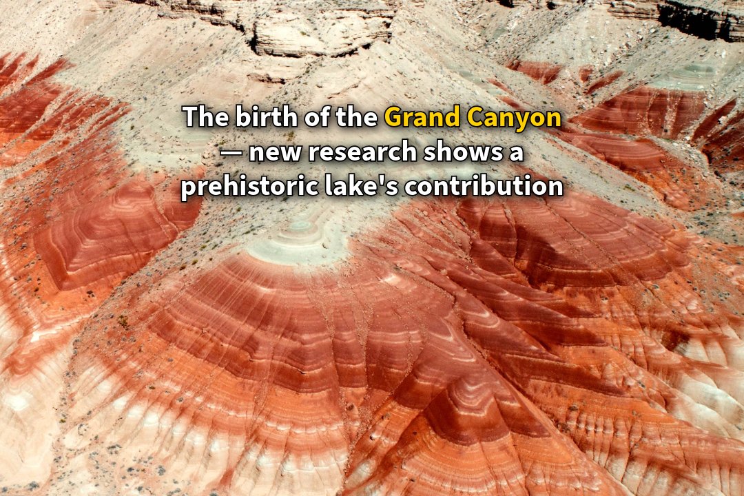
    How a prehistoric lake helped carve the Grand Canyon 💧 Scientific discussion about the formation of the Grand Canyon began in 1869, with an expedition led by John Wesley Powell, a pioneering geologist and future director of the USGS. Powell navigated the Colorado River by boat,
    Image
    6.7K

New to X?

Sign up now to get your own personalized timeline!

Create account

By signing up, you agree to the Terms of Service and Privacy Policy, including Cookie Use.

Terms·Privacy·Cookies·Accessibility·Ads Info·© 2026 X Corp.
Don't miss what's happening
People on X are the first to know.
Log inSign up
Advertisement
Advertisement