blk: (Default)
Rachel Carsen, part 8
June 26, 2020
13.7 miles
5:00 (4:35 moving)
1,602 ft elevation

I know I said two months ago that I'd finished the RCT, but now I -actually- have. The western terminus of the trail in North Park was extended another ~7 miles out, winding through North Park and other forested and fielded areas to Perry Hwy in Wexford. Since so much of it is in North Park, which is a SUPER popular hotspot for every outdoor person on weekends, I didn't want to touch this segment on a weekend, so I decided to take a Friday off work and do it.

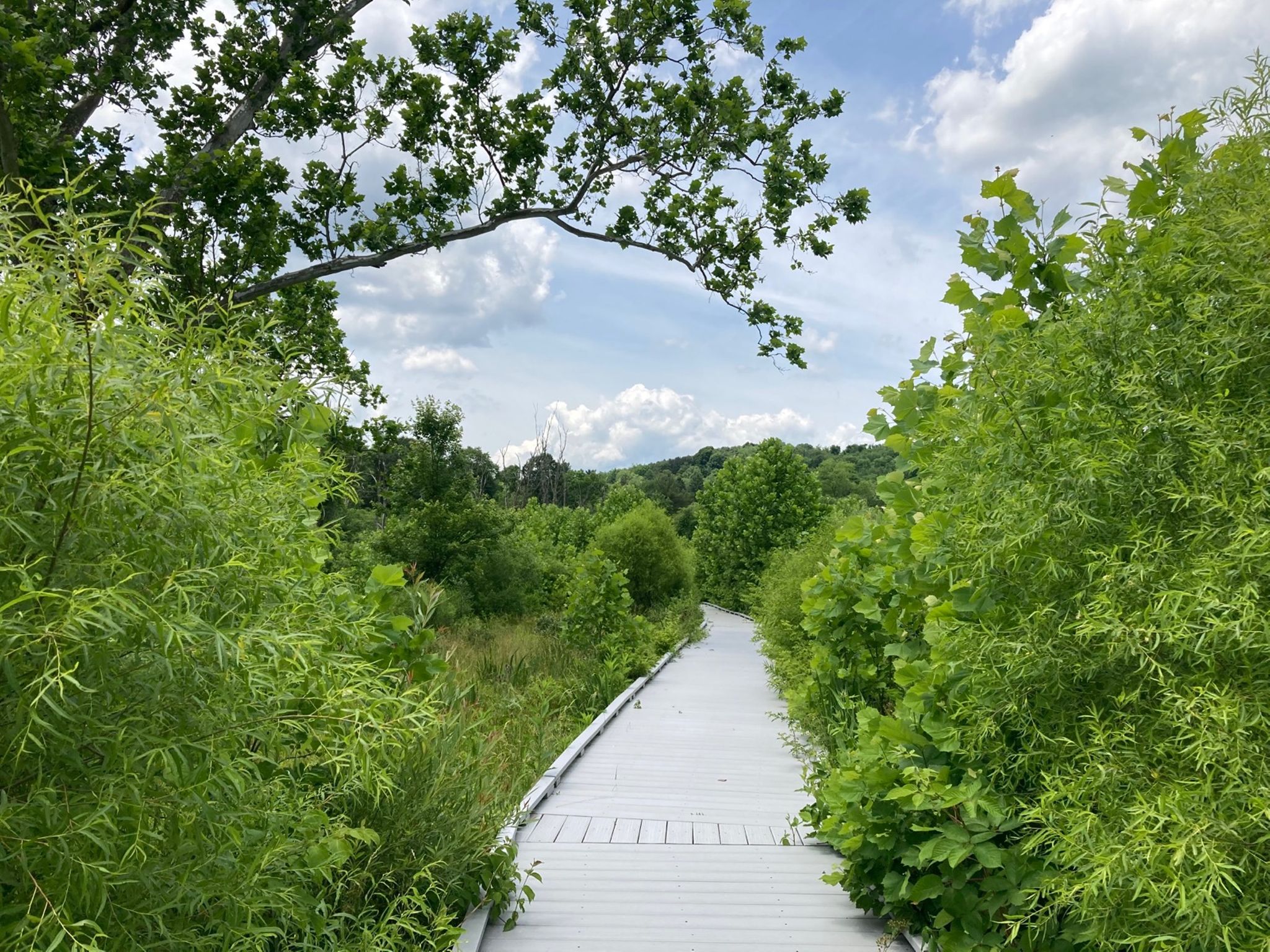
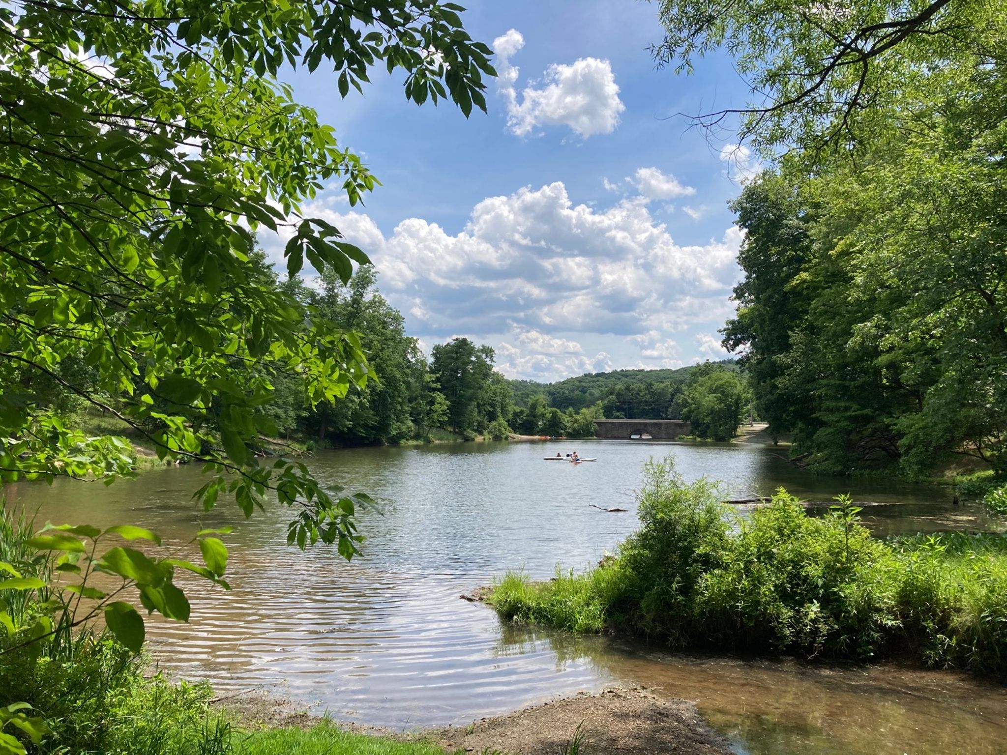
In comparison to all the other RCT segments, this one was practically idyllic. It was almost entirely on trail, with only a short segment along a minor road. There was no mud and what felt like mostly very gentle elevation changes. the trail was well-maintained and took a short stint through the Wahdo:Gwas restored wetland via an accessible trail.

As planned, I saw very few other people on the trail. I don't know how that would have compared to a weekend, but I don't expect to find out anytime soon. Weather was fine for the first part and definitely warm by the end, so finishing in the afternoon was nice.

One new feature of this hike (well, of the timing, not of the hike) is this is the first activity I've been on where I had my new phone (new SE). The phone is... fine? I like that things work and I especially like that my phone camera pictures look nicer. But it's also just a little bit bigger so that I now have to work to fit it into things like my pants pocket, or my pocket belt, or my bike bag, which is definitely annoying. Eh.

Image Image
blk: (Default)
June 2020: 105 miles

In Things That Are Not Surprising, I bike a lot more when I have Things to Do.

In June, I biked to: two appointments, two protests, two social evenings (sitting outside, distanced, small numbers), dropping off birthday cake to friends, and rock climbing.

The longest (and hottest, and most emotional) ride was for the Honoring Slain Citizens silent bike ride, which was well organized and REALLY well attended (several hundred, although I don't remember seeing a final count.
Definitely one of the biggest rides in Pittsburgh). We rode about 10 miles through city streets, stopped for a quick break and some speeches, then back to the start via different neighborhoods with chants/songs. The ride was officially escorted by the Pittsburgh police, which was definitely super weird, but they thoroughly behaved themselves, and I was proud to ride with my "Who do they protect and serve?" bike sign on full display. The ride was written up in some local news, and the photos did a good job of centering the black organizers and participants and not the myriad of white cyclists behind them. Jim made a large BLM sign for his big bike trailer, which carried a few bins of bike tools (which weren't needed) and extra water, which I helped hand out to grateful riders during the break and afterwards. The other protest ride was shorter (and smaller), but similar.

I made several trips to The Climbing Wall, which has opened, and I've tentatively decided I'm ok visiting them, thanks to them having reasonable policies of entry and mask-wearing and watching them enforce them. I'm still sticking to days and times when very few people are around, however. Turns out on Sunday morning I currently can get the entire place to myself for an hour. We'll see how long that lasts.
blk: (Default)
Riverview Park
June 13, 2020
7.44 miles
3:15 (3:00 moving)
1,155 ft elevation

It took the better part of the week before the soreness in my legs (and hands!) finally faded completely from the previous long hike, so while I still wanted to get in a good walk somewhere, I wasn't really motivated to find a big challenge. Thus I ended up at Riverview Park, a local park I've been in many times before (and used to live a block away from!) but never really explored much on foot off the main roads.

My goal (since I need to have goals) was to walk around the park as much as I could for a few hours without retracing my steps too much or walking on roads. Since this is a fairly compact park, most of the trail segments weren't more than a half mile or so before branching off, so I spent a fair amount of time looking at the trail map on my phone to find the right turns to take. But I successfully ended up with almost 7.5 miles of mostly non-overlapping paths by covering almost every trail in the park.

The park was surprisingly non-crowded, considering how family-friendly I would consider these trails, and being there on a weekend afternoon. I passed more deer than people for most of my time there, including a family with two small ones. In general, the trail was smooth and shallow and pleasant, although there were a couple "closed" trails I went on that had basically been entirely washed out by fallen trees, and those were an exciting break from calm paths as i figured out how to log-hop from one side to the other.
blk: (Default)
Fell behind on my hikelog. Not like I've been doing much else noteworthy.

I took a few days to recover from my three days at Raccoon Creek, but by the following weekend I was antsy from not doing anything, so went out again.

McConnells Mill
June 7, 2020
16.3 miles (PR)
7:30 (6:30 moving)
2,319 ft elevation

I picked McConnells Mill State Park after hearing good reviews about the trails there. This park was further out plus I worried about crowds plus I planned a longer hike so I decided to try for an earlier start than previous weekends. This was easier by myself, and I managed to start hiking by just about 9:30am.

I parked towards the north end of the park, intending to just do an straight out and back of the main trail, but once I got down to the creek, where it was a beautiful quiet morning with nobody around and some really lovely sights, I couldn't help but take some detours to see the dam and walk around a little on the Alpha Pass trail before starting south.

Once I got to the Gorge trail, I knew I was in for a good hike when I saw this sign. There were not many people out, although due to the time, the difficulty, or the distance I don't know. I made it to the parking lot at the other end in just under 3 hours, and took a longer break to eat lunch. I was feeling pretty good, so wandered around Hells Hollow trail to check out the waterfall and the crowds of people (from a distance), then back on the Gorge trail to head back.

I've been hiking enough now to have a pretty good idea of my limits and patterns. At around 7-8 miles (which was my turnaround point here) and up to 9, I feel pretty good about everything, such that a 10 minute sit can refresh me, and I look forward to walking more. Around 10 miles, my feet and joints start to really notice that I'm asking a lot of them, and politely ask if we can be done soon. About 12 miles, I'm feeling it all over in painful ways, and I'm fantasizing about being at the end. At 14 miles, everything sucks and hurts and is awful, and if I had the option to stop hiking right then and there and be carried home (without inconveniencing anybody else, of course), I would probably take it. Of course, on most trails, there is no such option (short of falling off a cliff and calling emergency rescue people), so I just had to keep walking, and even though I eschewed the last half mile of trail and took the road for a slight shortcut, I ended up at 16.3 miles, which I'm pretty sure is a personal record of walking in a single day for me.

And boy did everything huuuuuuurt. Once at the car I took off my shoes and just sat for a bit while I regained feeling other than pain in my feet. My hiker's rash was already in full bloom so I focused on not scratching that. The next few days my quads reminded me every step of why I thought a long hike was a good idea but I gotta say I'm still glad I did it. I would even do it again, although just a point-to-point might be slightly more appealing if it were an option.

Image Image Image
blk: (Default)
For my brthday this year, I got myself an eyelid infection. Yay. Really it's just a run-of-the-mill stye that went a little overboard, but basically the last 4 days have seen varying amounts of a swollen and super painful eyelid that just makes every eye movement suck.. I saw my eye doctor on Friday as a just-in-case visit, because I am lucky enough to be able to afford that, and got some antibiotic eye goo that will at least prevent it from getting worse, but also blurs my vision when I apply it. So I decided it would be wiser not to bike or drive on Friday or Saturday due to lack of proper depth perception.

Instead, I spent a bunch of Saturday lazing around being grumpy, then decided mid afternoon to stop doing that and do something else. I made some bread, did some yardwork, browsed cake recipes, walked to the grocery store, came home for a family zoom call, got takeout dinner for the first time in the last three months (pad thai), and then went next door to sit around with neighbors at appropriate distances around their new firepit sipping my birthday present wine.

Late evening I started the cake, which I baked and cooled before wrapping them up and going to bed.

Today I decided my eye was marginally improved and I wanted to get out, so I biked around delivering potatoes to friends and went climbing at my gym, which has recently opened. They seem to be taken pretty good precautions, but more importantly, people haven't come back yet. I was literally the only non-staff person there for the entire hour I was climbing. Kinda nice for me, but I really hope it's not financially crushing for them. Came home and iced the cake, and we each had a slice after dinner.

Now I have 3/4 of a cake that I need to figure out who to feed it to, and an eye that is slightly better but still irritating. So, it was a birthday, I guess.

Image
blk: (Default)
Raccoon Creek
May 28-30, 2020
32 miles (3 day total)

I've realized over the last couple months that not getting enough regular exercise makes me a really super anxious, cranky, depressed person unable to handle things that are normally no problem for me. And that unfortunately for me, "enough exercise" apparently involves a lot more than I get from working at home and doing my normal set of chores and occasional stretches or going for walks.

I had to use up some PTO in May so I took the last two days off and took myself camping at Raccoon Creek State Park, with the intention of doing a lot of hiking and a lot of relaxing for a few days, and not much else. I picked that weekend because the lake was still closed for swimming (it opened the following weekend), so I hoped it would be less crowded than maybe otherwise.

The Raccoon Creek official maps are slightly less useful than maps elsewhere because although they show the trails, they don't really show distances. I managed to get some information off AllTrails, but their specified hikes weren't exactly the ones I wanted to do, so I did some guesswork on how far my intended trails would be. I ended up actually less than a mile off of my estimate each day.

Thursday
7.4 mi
3:00 (2:46 moving)
997 ft elevation

I arrived early afternoon and set up the tent, then set off for a shorter loop by the lake. Right near my campsite is the Beach Trail, which heads downhill and intersects with the Valley Trail, which is a slightly shorter cut to the northern side of Raccoon Creek Road. From there I crossed to the Lake Trail, which was wide and flat and was a leisure wander by the northwestern bit of Raccoon Lake, where a few people were out fishing, but was otherwise mostly empty. The Lake Trail then wound up to intersect with the Forest Trail, which got way more interesting in terms of elevation. A loop around that and back to camp was about 7 miles, which left me about an hour to shower and finish up everything else. I didn't really take any breaks on this hike except to take a couple pictures.

I tried some new hiking shoes on this route, same kind as my boots, but in shoe form (yay ebay). They were... fine? It didn't make a difference in my ankles getting rashed (which still happens every time, although only a small area once I switched to low cut socks), and I think maybe it gave me slightly less traction (as I slipped a couple times on extra muddy spots).

Image Image Image

Friday
14.25 mi
7:04 (5:18 moving)
903 ft elevation

This was my biggest planned day: a wide loop around the west side of the park. I got a decent early start, anticipating a longer day. The main theme of this trail was probably "wet." There were huge patches of mud that covered the entire width of the trail, but also there was undergrowth next to the trail that grew out over the trail and was damp from recent rains as well as morning damp. The main results of which were that my pant legs were nearly constantly damp for the first half of the hike and my boots were thoroughly mud-covered (but I was glad I wore boots). Another effect of the excessive undergrowth was a very large number of spiderwebs across the trail. After the first hundred or so, I started using my hiking poles as web catches more than as actual hiking assists.

This was definitely underutilized trail. It was always completely clear where the trail was, thanks to the frequent blue blazes and the clear path (albeit only about a foot wide at times), but it was overgrown in some space so much that it felt like bushwacking (webs and all).

The first half of this went pretty smoothly, but the second half involved less speed and more breaks, including one prompted by some sudden sharp knee pain, which fortunately went away after some resting and stretching. I'd been expecting to meet up with some thunderstorms in the afternoon, but they all broke around me, and I managed to get back to camp and showered just before the rain started.

Image

Saturday
10.6 mi
4:30 (3:55 moving)
1,433 ft elevation

Jim joined me late the previous evening, so he joined me for this hike. We took the Beach Trail to the Valley Trail to the Lake Trail again, but this time turned east along the Forest Trail, then followed that around to the Heritage Trail, which took us back to camp. The trails here were MUCH better maintained than my previous day out, and even though there was more elevation, the whole thing was really pretty pleasant. I did slip once on a particularly muddy log, jamming my hand slightly painfully against my hiking pole handle (darn straps which are meant to keep the poles on your hands without effort), but nothing major.

Being the weekend, there were a lot more people, which made it less peaceful (other people are LOUD), but at least most of them were pretty decent about letting us pass with space. The second half of the loop I was getting really super exhausted, particularly trying to keep up with Jim's preferred hiking pace, and was extremely glad to see camp again. I then spent the rest of the afternoon and evening with my feet up doing mostly nothing but finishing my book, which was a nice way to end things. After a couple hours I could even walk again without too much suffering.

Sunday morning was bacon, packup, and head home.

Image Image Image

blk: (Default)
May 2020: 85 miles

I made an effort to get out for a few days this past month. I don't think it's enough, but it's something.

As I post this, there is a tiny spider (dime size, including legs) that made a web on the opening of my bike bag. I'm sure it's only been a few days since i've been out (i think? maybe it's been a week...), but man, that really drives in that everything is sitting around not getting enough use. I carefully tried not to disturb it, but I don't think it's going to be able to catch many bugs that way.
blk: (Default)
Well, not today it isn't. In fact, I took off from work in hopes that I could go hike today, but since I'm not interested in doing that in the rain, I'm home catching up on other things instead. Like hikelogging.

Dead Man's Hollow
May 16, 2020
6.8 miles (walking, 23 miles biking)
3:10 (2:40 moving)
1,075 ft elevation

After finishing Rachel Carson, I looked for a while to figure out what to do next. From my observations in the past couple months of hiking, I noted that trails in parks and "family friendly" trails are more crowded than I'm comfortable with. So I was on the lookout for less-curated trails with more elevation and fewer rave reviews. A friend recommended Ma href="https://alleghenylandtrust.org/green-space/dead-mans-hollow/">Dead Man's Hollow, which is a small conservation area just south of Pittsburgh. Online reviews of the hiking included people commenting on the trail steepness in places, one person who couldn't find the trailhead, and another person who commented on it being empty of people. All positives, in my book.

As a bonus, one of the entrances to the area is along the Great Allegheny Passage trail, which means it was bikeable - direct from my house, if I was willing to deal with the hill back up from the river at the end of the day, which I decided I wasn't, so I drove my bike 3 miles to a nearby trailhead at the Waterfront. Or at least, I almost did, but just as I was about to head out, Jim asked me for directions to the trailhead so he could meet me there (using his electric power assist bike, which makes him not afraid of hills), which disrupted my leaving pattern enough that I forgot my hiking backpack, and drove back home to get it. Then I forgot my hiking poles, but decided 45 minutes delayed was already enough and I'd forego them this trip. Also, the official, most convenient trail parking lot was closed. So I (along with everybody else) just parked in a nearby lot. Ugh.

Anyways, it was about 11.5 miles down the trail, or about an hour of not-too-hard pedaling down the GAP for me. Once there I found a place slightly hidden to change from biking clothes into hiking clothes and off we went. There was a trail map on the website, and a trail map on the entrance sign, but not really much of one on the apps I had, so there was a good bit of "let's see where this goes" along with a general sense of directional goal. It worked great for the north side of the area, and less well when we attempted to follow the run through the park, and the trail just sort of petered out. We bushwacked our way to the #2 trailhead, where there was a nice, clean, well-marked trail back around towards our start.

There were definitely more people here than on the RCT, but not too many to avoid.

The hiking part totaled less than 7 miles but I was still happy calling it a day, along with another hour ride back to my car.


Image
blk: (Default)
... but walking the Rachel Carson Trail is now not one of them, yay me.

OK, so -technically- I haven't finished it yet, since the official western terminus was extended a few years ago, but I've skipped that segment for now on the assumption that since it goes through North Park, it's going to be way more crowded. I might try hitting it on a weekday or a bad weather day sometime.

Rachel Carson, part 7
May 10, 2020
11.5 miles
4:35 (4:10 moving time)
1,719 ft elevation

This was definitely the easiest segment of the bunch, with 2/3 of the trail running through (well, more like the perimeter of) Harrison Hills County Park, and less than 250 ft of elevation between high and low points of the route. The beginning started by going up a ridge overlooking the Allegheny River, which made for possibly the best views of the entire trail (this was not a trail for scenic spots). After leaving the park we crossed the road into Trump country (according to the giant house sign) for a short road bit, then fortunately another nice bit through more woods.

It was a cool morning when we started out, which warned up to pleasant hiking temps. We had just sat down at the turnaround point for a rest and a snack when the wind picked up and I got too chilly to sit anymore (which is why there was so little downtime). We got about 2 minutes of light sprinkling, and then it went back to being warm and pleasant again. By the time we were back on park paths, it was night enough that many more people were out and it was getting to be one of the most crowded trails we'd been on so far. (Passing people every 5-10 minutes instead of once in an hour).

Despite the relative easiness of the route, I realized I had made a possible error in judgement by going on a long city bike ride the day before, as I was fairly exhausted. In the last few miles, I felt some minor chest aching at Jim's usual faster pace, so I slowed down to wherever point I didn't hurt at. Given that it went away as soon as I stopped pushing, and lack of any other symptoms or discomfort, I'm pretty sure it was just a pulled muscle, but I definitely did a lot of paying attention to my body for the last hour, and was quite glad to be done.

There wasn't much fanfare to the endpoint, just a quiet little sign marking the trail (and the three square rectangle blaze just before that).

Image
Image Image Image Image
blk: (Default)
Rachel Carson, part 6
May 2, 2020
13.4 miles
6:20 (5:20 move time)
3,013 ft elevation

This route had everything: ridiculous hills, dirt bikes, river crossings, extra mud, road crossings, sun, stinging nettles, freshly cut new trail, and painted rocks. It's like someone took all the notable parts of previous hikes and combined them.

The elevation map on this one looks weird because the previous week we turned around early, so this week we parked at the next lot, went back to where we left off the last week, then went forward another 4 miles, and back again. I had been expecting a couple big hills; there ended up being a couple more I wasn't planning on, due to a new section that was freshly rerouted off of what used to be road. The big hill, Burtner, was steep enough to practically crawl up in places, but there were several other hills that felt nearly as bad. This was the highest elevation week we've had so far, although not furthest in distance. Again, it's really hard to really capture the steepness in pictures.

One nice thing about this route is that, apart from 3 road crossings, none of the route was actually along roads. Being in the woods was pleasant, even when roads aren't that far away.

Every week I've been changing up the type of sock I wear to see if it makes a difference on my vasculitis. This week I decided to try knee high compression socks. Well, that made definitely made things distinctly worse, so yeah, don't do that again.

Image
Image Image Image Image


blk: (Default)
Rachel Carson, part 5
Apr 25, 2020
9.63 mi
4:30 (3:55 moving time)
2,157 ft elevation

This week also had a major hill, Crawford Run, which had some really impressive incline. Overall the hike was not so bad, because that one big hill was the only really challenging part. As a result it didn't feel like a very hard week, despite there being several other smaller hills. We also cut the hike shorter than I'd planned, because I wanted to get home at a certain time for a family video chat.

Most of this hike was very pleasant, and even more so because we got to try out some freshly cut trail that bypassed what used to be road, so only a couple short road segments on this day. The fresh trail looked to be at most a few weeks old, and we actually met some people on the way back who claimed to be actively working on parts of it. There was a lot of slippery mud in parts.

One fascinating part of this segment was passing by what I can only call a car graveyard. There were maybe a dozen? old cars that had been sitting there for a very long time, long enough that I cannot even tell how they got there. We walked around them looking at parts for a bit, although I assume anything valuable or functional is long gone. I don't know cars anywhere well enough to identify any part of it.

Another fun part of this hike is that we found a plethora of painted rocks! Not sure if we just happened to spot more, or if there really were more along this section. I made a collage and posted it to the group, where the author of several of them responded.

I also found a cute little snek friend sunning by one hill.

More hiker's rash, again. I've been trying a different kind of sock every week, without much different in effect. It comes on (or at least I notice it) after I stop hiking, is a mildly swollen reddish area for an evening, then fades to mildly tender red spots over a couple days, then is gone by the next week.

Image
Image Image Image Image
blk: (Default)
Rachel Carson, part 4
Apr 19, 2020
14.3 mi
6:00 (5:20 moving time)
2,174 ft elevation

This week we started on our first "big" hill (one of the ones I'd been warned about), Log Cabin, which goes up a dirt hill 400 feet in elevation in under 1/2 a mile, then immediately back down nearly as far. I was glad I'd practiced with the poles on the previous week, as I was able to get more of a rhythm with them and get more help from them. The hill wasn't so bad when we were fresh, but definitely a huge pain 14 miles later.

I hadn't actually planned to go that far, but I wanted to do a segment that started and ended near a parking lot, and it turned out there was nowhere to park along the trail until we got to the entrance of Agan Park. Oops. Well, I can claim it as a day PR for me, despite the pain it caused. The last couple miles (of the first half) were walking in a fairly secluded trail near the Allegheny River which was rather nice despite the hills, and had a few decent views. One of the few bits of roads we walked on passed by what could be a contender for Worst Bus Stop, at Pittsburgh St and Riddle Run Road.

This hike we found our first painted rock! Turns out this is a relative new thing, so of course I joined the local facebook group (advertised on the back of our rock) to post our pic, and got lots of friendly kudos.

Another hike, another week of hiker's rash. It's weird. I'd never gotten it before this endeavor (that I remember), and I don't get it any other time, including on 3 hour hikes around the neighborhood or 6 hour bike rides. I guess I've rarely done 5+ hours of strenuous walking before. The info I've been able to find says it's may be more common in otherwise healthy women age 50+, so maybe I'm just extra mature for my age? It also says it can be genetic, and my mom said she has gotten it before, so there's that. Still seems relatively minor, although it feels like it flairs up in the same places it did in previous weeks.


Image
Image Image Image Image Image
blk: (Default)
Rachel Carson, part 3
Apr 12, 2020
4.3 mi
2:03 (1:43 moving)
820 ft elevation
(numbers are for one way only)

I only remembered to start my Strava when we were at the turnaround, so actual mileage/time/elevation should be approximately doubled from what I recorded.

After the previous two weeks of ending up exhausted, Jim requested a shorter hike day, so we did two big hills and stopped at the parking lot right before the third. The hills this week were the first time I really stopped and thought "Wow, people actually RUN this thing? That's insane." Even though the hills here are not even the infamous ones, there were some quite steep sections. We attempted to get some pictures of the steepness but pictures really cannot capture the terrain as a whole. Made for some nice views, though.

I had ordered hiking poles, and tried them out for the first time this week. It was difficult to tell how much they helped - I'm sure I needed more practice to use them effectively, but it was interesting. I knew basically nothing about poles before shopping for them, and it seems that the majority of ones on offer differ in 1) how they expand, and 2) what material they are made of. For expansion, there are telescoping poles and collapsible poles, and for material, there is aluminum and carbon fiber. I wanted short and cheap, which meant I got collapsible and aluminum. Also purple, because pretty, and there was a warehouse deal. The biggest challenge seems to be figuring out how to hold both poles and also open a water bottle and drink from it, as so far I only have two hands.

The theme of this week was dirtbikes. We started in Emmerling Park, which was lovely, but as soon as we got past the main fields, there were dirtbikes on trails all around us (and passing us at least once), that did not stop all day. So. Much. Buzzing. Argh.

One fun moment: we sat down for a short water break after ascending one hill, and a young deer walked around... and practically right up to us. It didn't appear injured, but almost certainly had been around humans before and was not nearly as afraid of us as it should have been. I got a bunch of pictures and then we gently shooed it away.

Another fun moment: This sign.

The hiker's rash was back again this week, again appearing after we stopped hiking, again right above and below my sock line, again fading within a few days. 

Image
Image Image  Image Image Image Image


blk: (Default)
The previous week was so much fun, I definitely needed to do it again.

Rachel Carson, part 1
Apr 4, 2020
13.5 mi
5:20 (4:45 moving time)
1,883 ft elevation

We started at the same point as last hike, but this time went in the opposite direction. This week's hike had the most roads, and I think it would have even if we hadn't gotten off trail and taken the wrong road across the turnpike. I think it also had the fewest steep hills (although still had plenty of elevation). Overall, it didn't feel like as bad as the previous week, even though it was longer.

This was the only point where we really lost the trail, and ended up going a mile off-route, on what I -thought- was the route, thanks to following an outdated AllTrails map instead of looking more carefully at the blazings. At one point we started cutting through some bushes down a hill, and heard a man yell at us from a house in the distance "That's not the trail!" It should have clued me to back up further, but instead we just went around on the shoulder. Not a fun detour. We turned around in Emmerling Park, which was lovely and pleasant and a nice relief from the roads.

Shortly after we finished hiking, on the car drive home, I got another new experience: an odd rash on my ankles, right around the sock line. At first I pondered if it was a contact reaction with something, so I carefully didn't touch it after I noticed it, then when we got home I put all my clothes in the laundry and carefully took a shower. Which seemed to make no difference. Also, I noticed there were significant sections of it under my socks, as well as on the tops of my feet, where definitely nothing from nature would have been touching. The areas on my skin were reddish and lightly puffy, mildly itchy, and a little sensitive. After doing some studying and googling, I'm pretty sure it was exercise induced vasculitis, also known as hiker's rash, golfer's rash, and (amusing, to me), Disney rash.

Image
Image Image Image Image
blk: (Default)
Shortly after everywhere started getting serious about quarantine, and I realized my regular exercise was severely lacking, I decided on a quarantine project - hike the Rachel Carson Trail north of Pittsburgh. I mostly know about this trail because of the annual Challenge which is to do 35 miles of it in a single day (of daylight, or 15 hours). No way am I doing 35 miles in a single go, even if it was easy terrain, but I can definitely do sections. So I set out to do that (with Jim).

Rachel Carson, part 1
March 29, 2020
11.25 mi
5:30 (4:25 moving time)
1,340 ft of elevation

I decided to go from west to east, skipping the new section beyond North Park for now. We parked 5 miles east of North Park, so had a set goal. This was the first time hiking on the trail for either of us, so I wasn't entirely sure what to expect. I had (slightly outdated) guidebook files from a friend, could get enough signal to use AllTrails app, and the trail was well marked with yellow blazings. Still, I hadn't entirely realized that a minimally curated trail would not include river crossings, so when we came to our first stream, it stopped us for a bit. We had just finished several days of heavy rain, so the water was probably much higher than usual, but it was probably a couple feet at its deepest and maybe 20(?) feet across.

After wandering around in either direction looking for a better crossing point, I came back to the trail and saw another couple nearby, and confirmed yep, this was the recommended place to cross. So eventually, lacking better ideas and not really wanting to completely soak my shoes and socks this early in the day, I took off my shoes and socks, and carefully walked across. I'm not sure if "real" trail runners/hikers are just willing to go around with wet feet all day, but I'm not.

The trail ended up criss-crossing this stream and another one later. Several of the crossings had very convenient logs to walk across, and a couple more had rather inconvenient logs that I traversed, while Jim just splashed through shallow sections in his waterproof socks. You can see on the route map where we wandered around finding alternative ways of getting around particularly wet areas.

The trail was pretty well not-crowded until we got to North Park, where the trail sections were still fairly sparse, but the roads were packed full of people. We stayed away from those sections as best as we could, took a picture at the lake dam, took a break at the old Western Terminus (i.e., small parking lot), and then turned around and headed back.

That section was supposed to be 5 miles, so we added an extra mile in by wandering around at water crossings and I think only once briefly losing the trail. By the time we got back to the car, I was pretty well worn out and ready to be done. At least until the next weekend.

Image
Image Image Image Image
blk: (Default)
Apr 2020: 36 miles

Yeah I guess keeping up this log is a way of recording through the quarantine, at least to show the parts I'm not doing. April was a full month of WFH, so bike trips are me making up excuses to go somewhere so I have the energy to leave the house. The most successful trip was when Amazon accidentally delivered to me a case of the wrong flavor tea, so I offered it up on my local Buy Nothing fb group. I got 6 takers, so I divied up the tea into 6 packages, and delivered to their front porches. In the same trip I took a bike bag full of glass recycling down to the last nearby open recycling center (in the Strip), took the bike path to work to get some notes, and came home.

I need to use up some PTO by the end of this month. My current plan is to figure out when really nice days will be and take the afternoon to go on longer bike rides. I have more glass I can drop off, and a coworker has offered that I can pick up a game from her front porch, so there are a couple options there at least.
blk: (Default)
Mar 2020: 95 miles

That's not at all bad considering I only did my regular work commute for 6 days this month before I started WFHing. It's going to be a struggle to get that much this much, I think.

I've been finding excuses to go out and run (safe) errands on bike or on foot, as well as trying to take the long way to things. I went to Shadyside to borrow some tools for working on my floor. I made several trips to work (which is a total ghost town) to pick up various things that I left there and to help clean out the fridge. I went to CMU to drop off printer cartridges to recycle. I rode out to Edgewood to drop off my Nook in a friend's mailbox so she can have more books to keep herself busy. And I did an extra loop around Highland park just because.

On foot, I've also been to work and back, as well as to the store to drop off plastic recycling, and many trips around Schenley or Frick parks. My new hiking shoes are getting a lot of use. I'm still not getting near the workouts that I'm used to, and that's hard, on top of everything else that is hard.

As the weather gives us increasingly nicer days, I'm trying to convince myself to keeping going out. We'll see if I can keep it up.
blk: (Default)
Well this year is starting out with a great big failure in blogging, despite intentions. I can at least do this one thing.

Jan 2020: 115 miles
Feb 2020: 130 miles

Less than last year at this time, but still mostly keeping up with my goal monthly average. I took off one long weekend in Jan and two long weekends in Feb for traveling, but otherwise have mostly kept up the commuting. There have been far fewer days of really inclement weather this winter, and most of the unpleasant weather biking days have been rain, not cold. I acquired a nice pair of softshell pants last fall which do really well for wind, cold, and light rain, but not for actual rain. I haven't actually dug out my waterproof gloves because my bar mitts do a fine job on their own of keeping water out.

I rode the Frigid Bitch again this year. I rode on my own this year, going as fast as I wanted but also not having the benefit of sharing route knowledge, to my detriment when I picked a trail that ended up being an inch of icy mud, and slowed me down enough to miss a checkpoint I'd hoped to hit. I ended up with 5/7 checkpoints and came in 44/138. Didn't find any prizes that I was particularly thrilled about but I did find a lost pair of cheap sunglasses on the road which ended up fitting me perfectly, so I claimed those. I think I could have done much better had I chosen better routes but overall I'm pretty happy with how hard I rode.

Bike work: After the race the bike is overdue for a good bath and another lube job. Somehow riding several days in the rain did not much to wash the mud off. I did stop into PB to have them remove a staple from a tire because I was too lazy to take care of it myself. I took the old tube and will patch it for next time, though.
blk: (Default)
2019 edition of my book log. Only 20 books this year. I don't know why I stopped reading. I'm pretty sure I wasn't doing anything else more productive or better with my time. Oh well. 10 authors: 6 new, 8/2 female/male.

My recommendation of the year is The Golem and the Jinni by Helen Wecker.

I did an ok job recording things in Goodreads. At least, I filled in some of my past few years of reading in my account. Maybe I'll do better this year.

For history's sake:
2018 Book Log: https://blk.dreamwidth.org/332773.html
2017 Book Log: https://blk.dreamwidth.org/321554.html
2016 Book Log: https://blk.dreamwidth.org/676.html
2015 Book Log: https://blk.dreamwidth.org/300380.html


Books )
blk: (Default)
Dec 2019: 6 miles
2019 total: 1536 miles

I checked my bike computer on Jan 2 when I commuted it and it read.... 6. Oops. Between vacation, bike in the shop, bad weather, and probably general laziness, I guess I got like, one commuting day in December. But then I calculated my year total and it was only slightly lower than 2018, so I don't feel so bad.

In 2019 I rode in 5 events: Icicle Bicycle, Frigid Bitch, Pedal Pale Ale Keg Ride, an Underwear Ride and Pedal Pittsburgh. I commuted to work and from work to downtown and back on a fairly regular basis. I did some general maintenance to the bike, repaired some broken lights (which broke again), replaced the saddle, and got new commuting headphones.

This next year I hope to keep riding as much or more, do similar numbers of events, and do something about that road bike I have in the back of the shed that doesn't fit me - either get it better fitted or get rid of it.

Profile

blk: (Default)
blk

July 2020

S M T W T F S
   123 4
5678910 11
12131415161718
19202122232425
262728293031 

Syndicate

RSS Atom

Most Popular Tags

Expand Cut Tags

No cut tags
Page generated 23 Feb 2026 02:52