Aug. 7, 2025 — The National Center for Supercomputing Applications and the University of Illinois Urbana-Champaign were awarded a $25.8 million contract from the U.S. National Geospatial-Intelligence Agency (NGA) for high-performance computing in support of NGA strategic partnerships, advancement of artificial intelligence, and machine learning and logistics for data production on a global scale. NGA Director Vice Admiral […]
NCSA to help build world’s most powerful geospatial system
August 2, 2019 by
NCSA has announced a new collaboration to produce digital elevation models (DEM) of the entire Earth, among other geospatial research projects. “This is the beginning of building a long-term strategic relationship between NGA and the University of Illinois, centered on high-performance computing and data analysis. The Blue Waters collaboration is the first of what we anticipate will be many years of research collaborations between NGA and Illinois faculty as well as NCSA.”
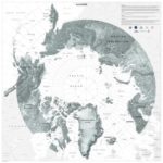
Supercomputing 3D Elevation Maps of Alaska on Blue Waters
September 2, 2016 by
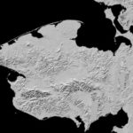
Today, the National Geospatial-Intelligence Agency and NSF released 3-D topographic maps that show Alaska’s terrain in greater detail than ever before. Powered by the Blue Waters supercomputer, the maps are the result of a White House Arctic initiative to inform better decision-making in the Arctic. “We can’t live without Blue Waters now,” said Paul Morin, head of the University of Minnesota’s Polar Geospatial Center. “The supercomputer itself, the tools the Blue Waters team at NCSA developed, the techniques they’ve come up with in using this hardware. Blue Waters is changing the way digital terrain is made and that is changing how science is done in the Arctic.”