
–
orkid 260vtol
ISR drone
Variant
Empowering Security and Surveillance with Drone Precision

001 – ISR VARiant
Transforming
ISR drone Missions
Across Industries
Delivering real-time intelligence for critical applications in defense, infrastructure monitoring, and public safety.
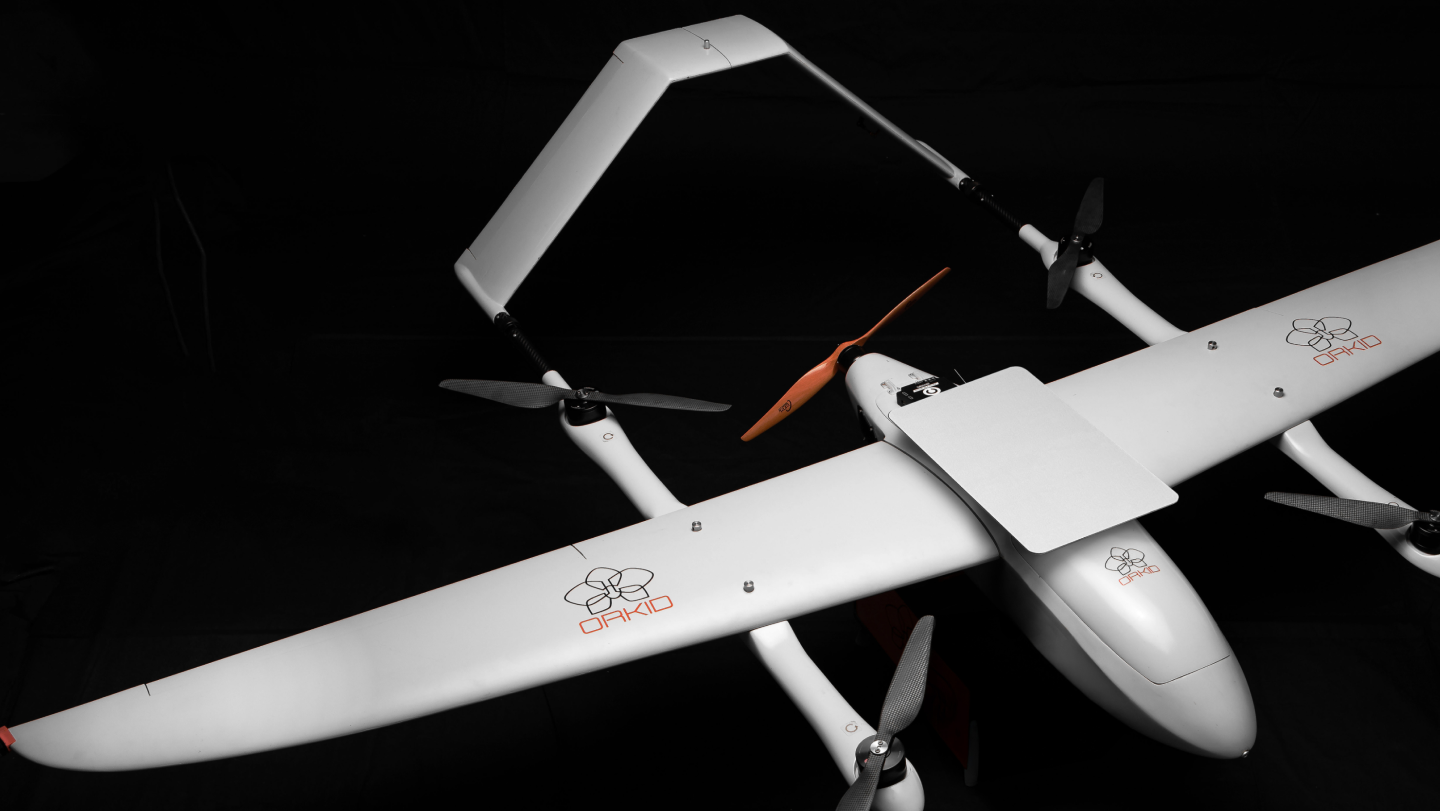
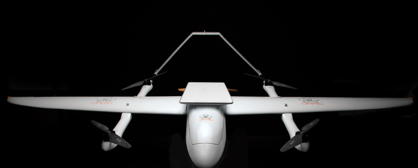
The ORKID 260VTOL ISR Variant delivers unmatched performance for ISR drone missions, offering 120 minutes of flight time, and up to 160 km operational range, and wind resistance up to 12 m/s. With seamless Starlink satellite integration, it enables fully autonomous operations, providing real-time video and telemetry through an intelligent C2 Link—eliminating the need for ground infrastructure.
Equipped with modular payloads, this drone supports ISR missions with AI-powered tracking, 40x to 180X optical zoom, and advanced sensors like the NDAA-compliant NextVision Starling, Raptor, or the Trilium HD40-LVV cameras which feature 1280×1024 thermal imaging and a 3000m laser range finder. ORKID ensures rapid deployment, ready to fly in under 5 minutes, making it ideal for the most demanding applications.
002 ISR Features
Empowering real-time intelligence for Critical ISR Drone Missions with advanced optics and Cost-Effective Operations
Eyes in the Sky,
Precision on the Ground
001
Multi-Sensor Streaming for ISR Drone Missions

002
Onboard Video Encoding and Recording

003
Object Tracking

004
E-Stabilisation

005
Roll Stabilisation

a01
ISR Ready
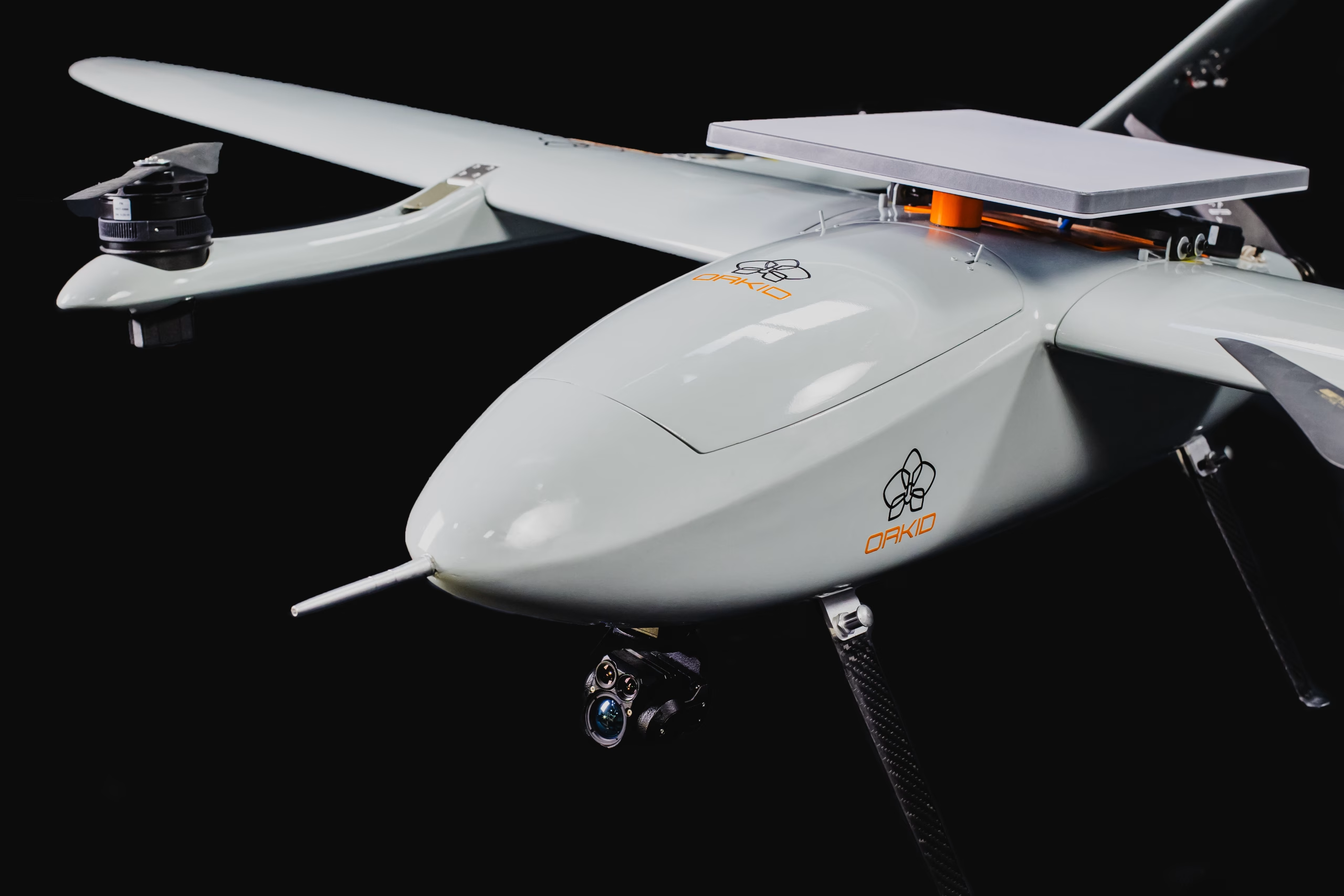
Equipped with high-definition electro-optical (EO) and infrared (IR) sensors, this ISR drone ensures precise real-time reconnaissance and surveillance.

a02
Payload Flexibility
Supports fully autonomous missions, including takeoff, landing, and waypoint navigation, with precision-controlled landing via advanced GPS guidance.

a03
Autonomous Flight
Supports fully autonomous missions, including takeoff, landing, and waypoint navigation, with precision-controlled landing via advanced GPS guidance.

a04
Secure Data Transmission:
Encrypted communications ensure data security during ISR missions.

Eyes in the Sky, Precision on the Ground
Empowering real-time ISR Drone Missions with advanced optics and costs-Efficient Operations
[01]
Starlink Integration for Autonomous ISR
Experience seamless operations with real-time video and telemetry via intelligent C2 Link—no ground infrastructure needed.
[02]
Modular Payload Flexibility
Supports advanced ISR payloads like the NDAA-compliant NextVision Starling and Raptor cameras with AI-powered tracking and 80x optical zoom.
[03]
Sustainable and Efficient Performance
100% electric, with 90 minutes of flight time, 120 km operational range, and superior wind resistance of 12 m/s.
[04]
Rapid Deployment for Mission Success
Smart cloud-based mission planning ensures readiness in under 5 minutes for the most demanding applications.

/003
Tech Specs
Tech
Specifica–
Tions
Tech SpecificaTions
ORKID 260VTOL – ISR Variant
001
Max Speed
80 km/h (22 m/s)

002
Max Flight Time
120 minutes (with standard payload)
003
Range
160 km (BVLOS enabled)
004
Max Wind Resistance
12 m/s (Operational)
b01
ISR Ready
Full Satellite Integration (Starlink) – no need for radio towers or ground infrastructure, enabling centralized operations worldwide.


b02
Payload Flexibility
Modular support for ISR and Mapping systems with MAVLink-enabled smart functions.

b03
Autonomous Flight
Fully autonomous operations with mission planning powered by ORKID’s intelligent cloud platform.

b04
SATCOM
Integrated Starlink terminal for encrypted, high-bandwidth, global connectivity; eliminates reliance on terrestrial radio infrastructure.

b05
Autopilot
NDAA-compliant NVIDIA Jetson V6X architecture for onboard AI inference.

b06
EO/IR
Simultaneous Real-Time EO/IR Video Streaming via SATCOM.

b07
Sensor Redundancy
Redundant GNSS, IMU, magnetometers for reliability.
b08
High-Precision Sensors
State of the Art Sensor Technology.

Innovation with Purpose
We believe that every technological breakthrough should serve a clear, meaningful goal. At ORKID, our commitment is to create UAV solutions that combine innovation, efficiency, and reliability for real-world impact.
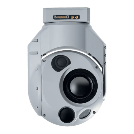
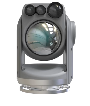
TRILLIUM
HD40-LVV
High-Confidence ISR with Superior Object Identification

The Trillium HD40-LVV delivers unmatched EO/IR identification, geolocation accuracy, and onboard intelligence—optimized for aerospace-grade ISR where precision and reliability are mission-critical.
[ 001 ]
High-End Capability
Dual-sensor payload: EO 1920×1080 + LWIR 1280×1024 for superior day/night ISR
180× EO zoom (30× optical + 6× digital) enabling long-range positive identification
Onboard scene, geo, and target tracking for autonomous ISR operations
Real-time geopointing and geolocation with IMU co-located to sensors (≈1.5° system accuracy)
MISB-compliant video with embedded KLV metadata for military C2 systems
Integrated AI/ML processing onboard for instant execution of user-defined algorithms
Optimized SWaP-C (750 g, ~15 W avg), ITAR-free, mission-proven design
Best-Fit Missions
Tactical ISR
Border & Maritime Surveillance
Counter-Illicit Trafficking
High-Precision Target Identification
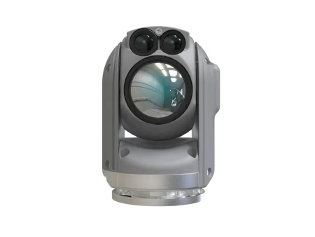
Nextvision
raptor
Long-Range Strategic ISR for Wide-Area Operations
High-performance EO/IR payload engineered for extended-range intelligence collection, deep look capability, and persistent surveillance across vast operational theaters.
[ 002 ]
High-End Capability
Electro-Optical (EO): 1920 × 1080 (Full HD)
EO Zoom: Up to 80× continuous
Typical configuration: 40× optical + 2× digital
Thermal (LWIR): 1280 × 720 (HD thermal)
Thermal Zoom: Up to 8× digital
Stabilization: High-precision 3-axis stabilized gimbal
Operational Focus: Long-range ISR, high-altitude surveillance, strategic overwatch
Best-Fit Defense Missions
Persistent Tactical ISR
Maritime Domain Awareness (MDA)
Strategic Border & Coastal Monitoring
Nextvision
STARLING
Compact EO/IR ISR for Tactical Overwatch
Lightweight, stabilized EO/IR payload optimized for real-time surveillance, persistent tracking, and long-range observation from VTOL ISR platforms.
[ 003 ]
High-End Capability
Dual-sensor payload: EO 1920×1080 + LWIR 1280×1024 for superior day/night ISR
180× EO zoom (30× optical + 6× digital) enabling long-range positive identification
Onboard scene, geo, and target tracking for autonomous ISR operations
Real-time geopointing and geolocation with IMU co-located to sensors (≈1.5° system accuracy)
MISB-compliant video with embedded KLV metadata for military C2 systems
Integrated AI/ML processing onboard for instant execution of user-defined algorithms
Optimized SWaP-C (750 g, ~15 W avg), ITAR-free, mission-proven design
Best-Fit Missions
Tactical ISR
Border & Maritime Surveillance
Counter-Illicit Trafficking
High-Precision Target Identification

All-Weather,
Mission-Ready
Architecture
The ORKID 260VTOL is engineered with IP65-rated protection across critical avionics, propulsion electronics, and payload interfaces—ensuring reliable ISR operations in harsh and unpredictable environments.
001
IP65 Protection Across Critical Electronics
Full Satellite Integration (Starlink) – no need for radio towers or ground infrastructure, enabling centralized operations worldwide.
002
Designed for Harsh Operational Environments Certified protection for missions involving rain, sea spray, dust, sand, humidity, and wind-driven particulates, supporting maritime, border, and expeditionary deployments.
003
Mission Continuity in Degraded Weather Environmental sealing reduces risk of moisture-induced failures, ensuring continuous ISR, SATCOM connectivity, and sensor operation during weather-degraded missions.
/004
Intelligence + surveillance
( xxx )
Redefining Intelligence and Surveillance: From Defense to Infrastructure Monitoring

( 004 )
Elevating ISR Drone Capabilities Across Critical Applications
The ORKID 260VTOL ISR Drone Variant revolutionizes industries where precision and reliability are essential. From border security and critical infrastructure inspections to public safety and military operations, ORKID offers unparalleled efficiency and performance. With Starlink integration, advanced modular payloads, and rapid deployment capabilities, the ISR Variant redefines autonomous intelligence and surveillance standards.

( xxx )
Navigation &
Correction Services
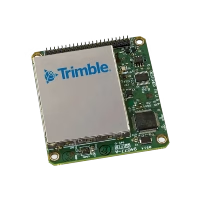
001
Trimble PX1-RTX for high-precision aircraft navigation and long distance flight
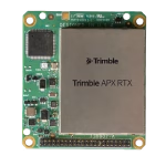
002
APX-RTX onboard for Phase One & LiDAR correction services
003
Benefits
- Centimeter-level Accuracy
- Reduced Need for GCPs
- Time & Cost Savings
/005
Get in touch
ready to elevate your operations?
(contact)
