Raybird UAS

Raybird is a technological breakthrough — once deemed impossible, now a decisive advantage both on the battlefield and deep behind enemy lines
Frame 001

Technical Specs

Flight Duration

28+ hours

Wingspan

2.96 – 4.2 m

MTOW

23 kg

Maximum Flight Range

2,500 km

Maximum Flight Altitude

5,500 m

Data Link Range

200+ km

Payload Capacity 

5–10 kg 

Speed 

80 / 110 / 140 km/h 

Powerplant 

EFI, four-stroke engine 

Fuel Type 

Gasoline AI-95 

Deployment Time 

Up to 25 minutes 

Operating Temperature Range 

-35°C to +55°C 

Automatic Takeoff and Landing 

Mechanical catapult launch, parachute recovery onto airbag

Payload

Frame 001
Copy of Graphic 1 Phase One iXM GS120 small
sar1 1
rfl

Gyro-Stabilized Multisensor Gіmbals

Aerial Photo Cameras

Synthetic Aperture Radar (SAR)

Radio Frequency Locator

Medium-Wave Infrared (MWIR) and Electro-Optical (EO) imaging
4-axis stabilization
Dual simultaneous H.265 video streams provide situational awareness and detailed target view
Built-in video processing, including image stabilization and target tracking
Half the weight and power consumption compared to industry standard
Resolution: up to 11,664 × 8,750 pixels
Pixel Size: up to 5.3 µm
Frame Rate: up to 3 fps
Operating Temperature Range: -10°C to +40°C
Resolution: from 0.3 to 10 meters
Maximum Imaging Range: up to 20 km
Moving Target Detection: up to 15 km
Operating Altitude: up to 5,000 meters
Weight: 4 kg
Effective triangulation of enemy electronic systems at distances over 25 km

System

p 4 image 1

Transport case

p 4 image 2

Catapult

p 4 image 3

Antenna system

p 4 image 4

Mobile GCS

p 4 image 5

GCS

p 6 bg

Payload

Takeoff and Landing System

Raybird is equipped with an automated landing system that operates in both standard and emergency scenarios. The landing process relies on a parachute and a pneumatic airbag

During descent, a mechanism flips the aircraft, allowing it to land upside-down onto the airbag, protecting both the payload and the system itself

The system autonomously determines the optimal moment to deploy the parachute and activate the airbag. Safety features prevent accidental or unauthorized deployment

Applications

Deep Reconnaissance

Targeting and Precision Fire Control

Radio Frequency Intelligence

Extend Data Transmission

Border Control

Maritime Surveillance

Power Line Inspection

Pipeline Monitoring

Road Inspection

Wildfire Prevention

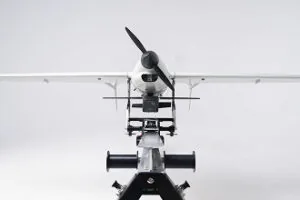
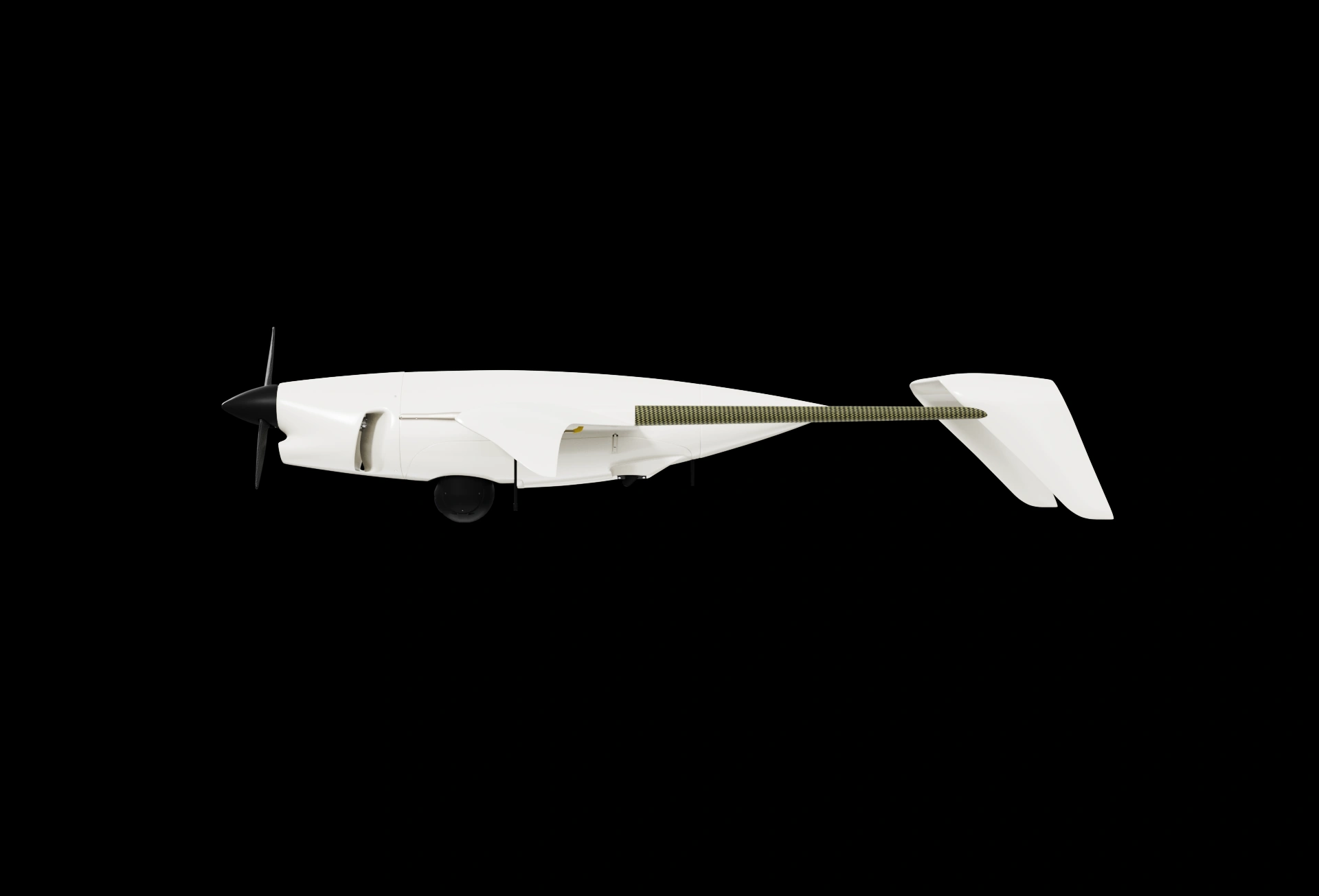
Intelligence missions deep behind enemy lines. High-resolution video. Compact form = low detectability by air defense systems
More details
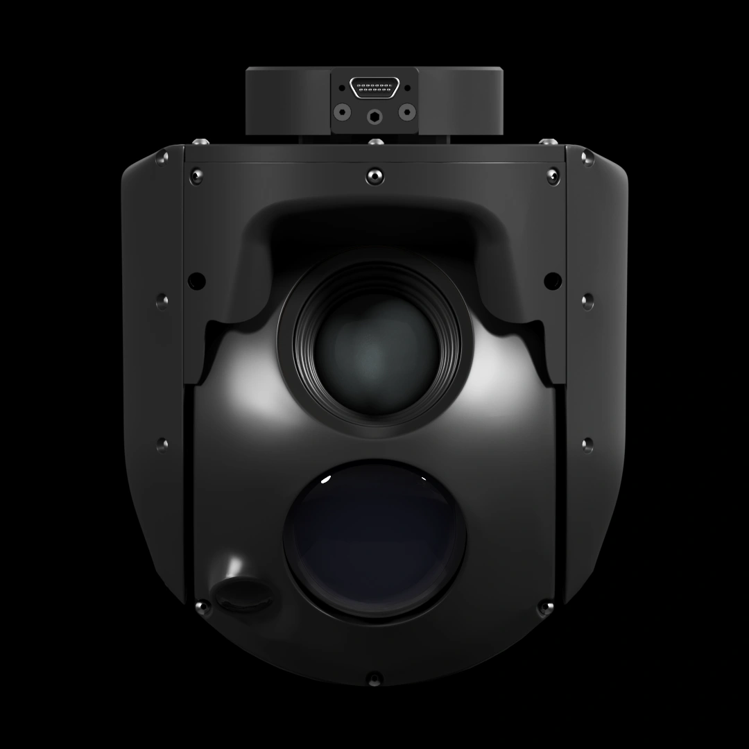
Raybird transmits target coordinates in real time and integrates with systems like HIMARS, Krab, and Caesar. Powerful multi-sensor cameras with day and night modes enable tracking and visual confirmation from altitudes above 2,000 meters — keeping the target in frame until it’s destroyed
More details
Raybird can be equipped with an RF Locator module that detects enemy emitters — including air defense systems, EW units, radars, and communication signals. The RF Locator accurately pinpoints hostile activity, even when concealed or camouflaged. This enables rapid response: identify the threat and eliminate it
More details
Raybird operates as a relay, extending the data link by 50–80 km. This ensures stable communication even where direct control is impossible due to terrain, obstacles, or electronic warfare
More details
Raybird performs continuous patrolling of the border strip — either 24/7 or on demand. It detects targets, tracks them in real time, and transmits coordinates for response
More details
Raybird conducts 24/7 aerial patrols over the sea, detecting suspicious activity such as illegal fishing, drug trafficking, or water pollution. With a flight endurance of up to 30 hours, Raybird doesn’t just detect — it tracks moving targets. This makes it a highly effective maritime surveillance tool for border guards, coast guards, or naval forces
More details
Raybird enables large-scale inspection of power lines without involving ground or aerial equipment — making it more cost-effective, faster, and safer. The aircraft performs aerial imaging, detects damaged sections, identifies wire positioning on poles, and helps monitor high-risk zones
More details
Raybird provides detailed monitoring of pipelines and surrounding infrastructure — both during routine inspections and emergency situations. It captures high-quality images, orthomosaics, and 3D models, and streams HD video in real time for rapid condition assessment
More details
Raybird enables rapid inspection of road surfaces and infrastructure without disrupting traffic or requiring heavy equipment. The aircraft detects cracks, deformations, subsidence, and other damage with high precision. It also monitors traffic, checks bridge conditions, and identifies potential man-made threats at an early stage
More details
Raybird conducts aerial reconnaissance of forest fires — both for early ignition detection and coordination of rescue operations. It helps identify hot spots, assess the scale of fire spread, and transmit real-time data to firefighting teams
More details
group 1
Privacy Overview

This website uses cookies so that we can provide you with the best user experience possible. Cookie information is stored in your browser and performs functions such as recognising you when you return to our website and helping our team to understand which sections of the website you find most interesting and useful.