Geospatial Imaging
Designing and manufacturing precision optics and camera modules for geospatial mapping — seeing is believing.
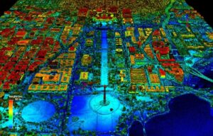
Visible or Near infrared imaging helps 3D point clouds paint a clear picture.
Total Stations
Mobile Mapping

LiDAR Optics

Camera Modules

A closer look at what it takes
Sunex Inc. provides advanced optical and imaging solutions for geospatial mapping and remote sensing applications, with decades of experience in precision lens and camera module design. Our portfolio includes high-resolution, wide-angle, and low-distortion lenses optimized for aerial, terrestrial, and mobile mapping platforms. Sunex 2D vision solutions complement 3D point clouds, enabling accurate terrain modeling, volumetric analysis, and precise geospatial intelligence.
Proprietary active alignment processes ensure perfect integration between optics and sensor modules, while DXM™ and SXM™ technologies allow modularity and flexible deployment. With ISO-certified global manufacturing, rigorous quality control, and full lifecycle support—from concept to series production—Sunex empowers geospatial OEMs to deliver reliable, high-resolution imaging systems that support mapping, surveying, and GIS applications.
GeoSpatial Product Portfolio
A curated list of lenses with large FOVs, low distortion, and highest imaging quality in support of your application requirements
Geospatial Camera Modules
In-house expertise and capabilities for lens and PCB design, manufacturing, active alignment, and testing to deliver a full imaging solution.
Custom Imaging Solutions
If your application pushes the boundaries of what has been done and drive NextGen solutions. Our Imaging System Builder is a good start.
