

Colonel Mordaunt's Cock Match. At Lucknow, in the Province of Oude, in the Year 1786, at which were present several High and Distinguished Personages.
Laurie & Whittle / Johann Zoffany / Richard Earlom
•1794
• View Details →Recent Additions
Explore our extensive collection of new inventory, updated throughout the day. See all new inventory »
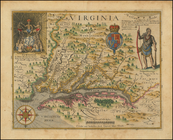
Virginia . . . John Smith's Map of Virginia -- First German Edition Fine dark impression of John Smith's seminal map of Virginia, wh...
Matthäus Merian / John Smith
Frankfurt / 1627
W/H: 14.5 x 11.5 inches
Condition: VG
Stock#: 103707
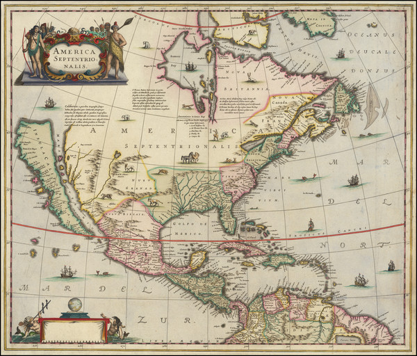
America Septentrionalis First State of Hondius's Map of North America, A Map Central to the Myth of California as an Island. Striking example...
Henricus Hondius
Amsterdam / 1636 circa
W/H: 22 x 18.5 inches
Condition: VG
Stock#: 117216
![[ First Map of the Great Lakes ] La Louisiana, Parte Settentrionalle, Scoperta sotto Protettione di Luigi XIV, Re di Francia . . .](https://storage.googleapis.com/raremaps/img/medium/120147.jpg)
Venice / 1691
W/H: 17 x 10 inches
Condition: VG+
Stock#: 120147
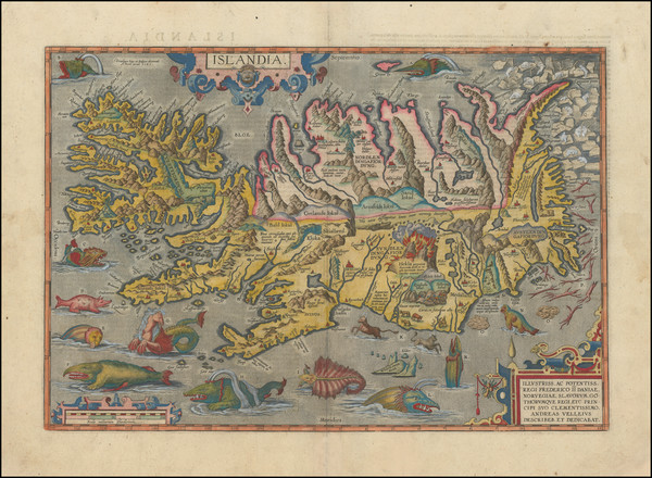
Islandia Ortelius' Sea Monster Map of Iceland. Handsome example of Ortelius' classic map of Iceland, one of the most decorativ...
Abraham Ortelius
Antwerp / 1609
W/H: 19 x 13.5 inches
Condition: VG+
Stock#: 100508
London / 1629
W/H: 8.5 x 13 inches
Condition: See Description
Stock#: 103969
![[ 17th Century Missionary Map of Iraq ] Vera Delineatio Civitatis Bassorae Nec non Fluviorum Insularum, Oppidorum pagorum et terrarum ei adiacentium, in quibus passim habitant familiae Sabborum Sive Mendaiarum qui Vulgo voconatur Christiani Sti. Joannis . . . 1653](https://storage.googleapis.com/raremaps/img/medium/120028.jpg)
Rome / 1653
W/H: 17 x 13.7 inches
Condition: VG
Stock#: 120028
![[ Flinders Atlas with Rare Revised Charts ] A Voyage to Terra Australis; undertaken for the purpose of completing the Discovery of that vast Country, and prosecuted in the years 1801, 1802, and 1803 in his Majesty's Ship the Investigator…](https://storage.googleapis.com/raremaps/img/medium/105794.jpg)
London / 1814 - 1829 (but 1835)
W/H: 19.5 x 27.25 inches
Condition: VG
Stock#: 105794
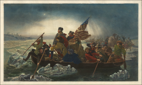
Washington Crossing the Delaware An Iconic Revolutionary War Image Finely engraved version of this important early painting, Washington Crossing the D...
Emanuel Gottlieb Leutze / Paul Girardet
New York / 1853
W/H: 38.25 x 22.25 inches
Condition: VG
Stock#: 120310
![[ The Complete Uraniborg–Stjerneborg Section from Blaeu’s Dutch Atlas Maior with Magnificently Colored Engravings of Tycho Brahe's Observatory and Its Instruments ] Eerste Deel des Aerdkloots-Becshryving, Inhoudende de Afbeeldingen en Beschryvingen der Landen op het Aerdryck . . . MDCLXIIII](https://storage.googleapis.com/raremaps/img/medium/118471.jpg)
Amsterdam / 1664
W/H: 14.5 x 22.2 inches
Condition: VG+
Stock#: 118471

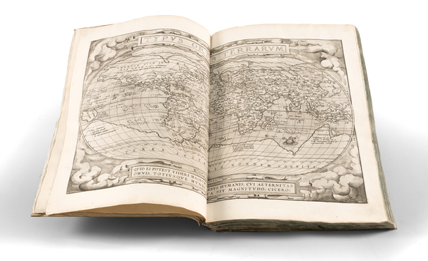
Typus Orbis Terrarum Ortelius' Landmark World Map One of the most famous world maps ever made, Ortelius's Typus Orbis Terrarum featu...
Abraham Ortelius
Antwerp / 1609 circa
W/H: 19.5 x 14 inches
Condition: VG
Stock#: 90163
Philadelphia / 1846
W/H: 61.5 x 39 inches
Condition: VG
Stock#: 118928
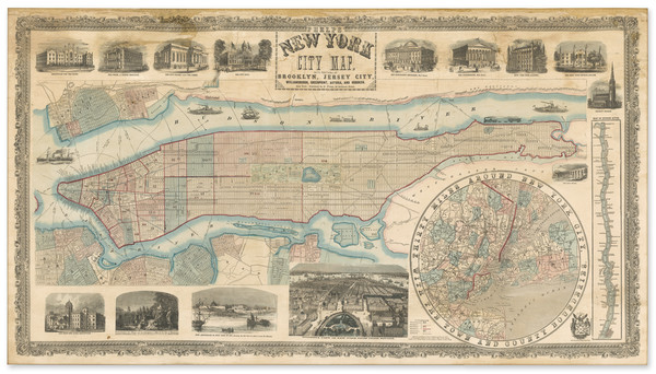
New York / 1857
W/H: 45.75 x 25 inches
Condition: Good
Stock#: 97126
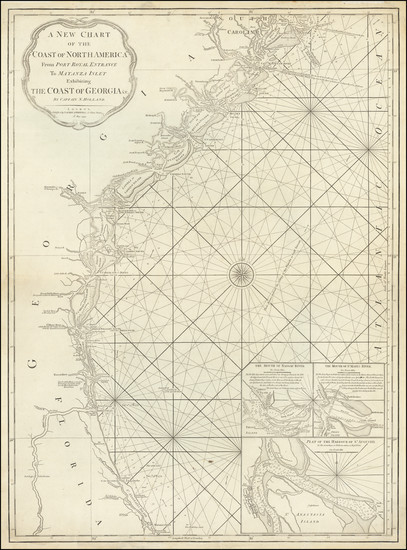
A New Chart of the Coast of North America From Port Royal Entrance To Matanza Inlet Exhibiting The Coast of Georgia &c. By Captain N. Holland . . .1794 Rare 18th Century Southeastern Coastal Chart from a Mysterious Source Extremely rare separately issued chart of the c...
Richard Holmes Laurie / James Whittle
London / 1794
W/H: 20.5 x 28 inches
Condition: VG
Stock#: 120510
![[ Photography - History ] [Manuscript journal with drawings by British miniature portrait artist, phrenologist and experimenter in daguerreotypes, recording daily experiences in New York City and Albany: mentions Eben Horsford, Robert Cornelius, George Prosch]](https://storage.googleapis.com/raremaps/img/medium/114406.jpg)
New York City and Albany, N.Y. / 1840
W/H: 5 x 7.75 inches
Condition: VG
Stock#: 114406
![[American Whaler of New Zealand and Australia] The Ship Samuel Robertson Log Book 1837 Kept by Silas Tinkham [Log of Pacific whaling voyage from 1837 to September 18, 1839]. Remarks on board Ship Samuel Robertson of New Bedford](https://storage.googleapis.com/raremaps/img/medium/117544.jpg)
At sea / 1837 - September 18, 1839
W/H: 9.5 x 15 inches
Condition: Fair
Stock#: 117544
Amsterdam? / 1600 circa
W/H: 19.25 x 14 inches
Condition: VG
Stock#: 84578
![[ Atlas of American Ports] Portulano De La América Setentrional Dividido en Quatro Partes, Aumentado y Corregido](https://storage.googleapis.com/raremaps/img/medium/99354.jpg)
ATLAS OF AMERICAN PORTS | Portulano De La América Setentrional Dividido en Quatro Partes, Aumentado y Corregido Very Rare Spanish Atlas of America: Maps of the Gulf Coast, Texas, Florida, Antilles With the First Separately E...
José Joaquín de Ferrer y Cafranga / Direccion de Hidrografia
Madrid / 1818
W/H: 14 x 9.5 inches
Condition: VG
Stock#: 99354
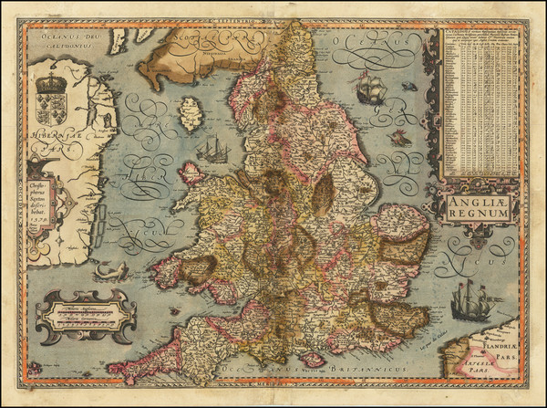
Antwerp / 1570
W/H: 16.25 x 11.25 inches
Condition: VG+
Stock#: 94771
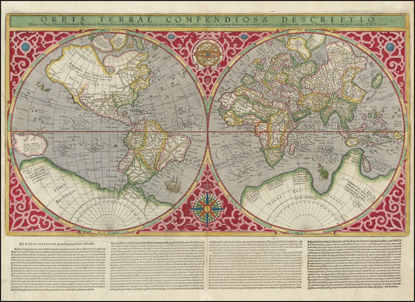
Geneva / 1587 (1595)
W/H: 20.5 x 14 inches
Condition: VG
Stock#: 116277
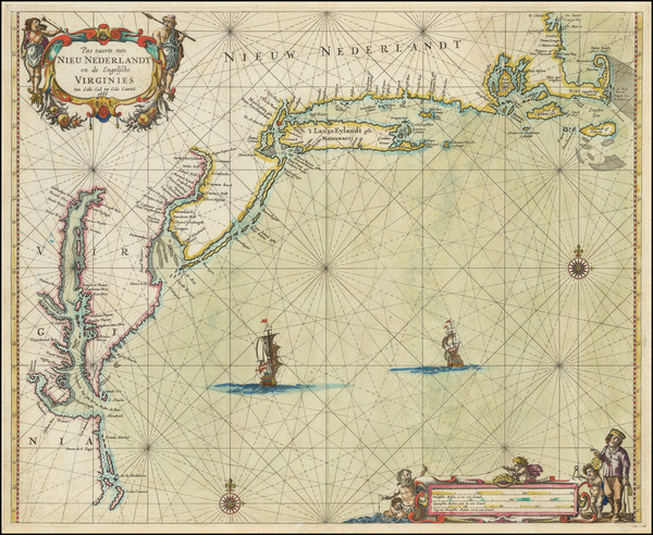
Amsterdam / 1666
W/H: 21 x 17 inches
Condition: VG+
Stock#: 120546

Visit Our La Jolla Gallery
We welcome collectors and scholars Monday–Friday, by appointment. Contact us to arrange a private viewing of material tailored to your interests.
Barry Lawrence Ruderman Antique Maps Inc. 7407 La Jolla BoulevardLa Jolla, CA 92037
United States
Phone: 858-551-8500
Arrange a Visit( showing of total)
Sort Options
Filter Options
No items found from this maker in this category in this collection matching your Collection Stats filters ().
Try adjusting your filters to see more items.
All items from this maker in this category in this collection have been sold. There in the Sold section. No sold items found for this maker in this category in this collection. There available in the For Sale section.
No Items