-

Landing Page
-
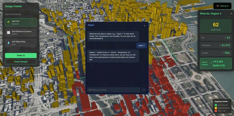
AI Chat Bot
-
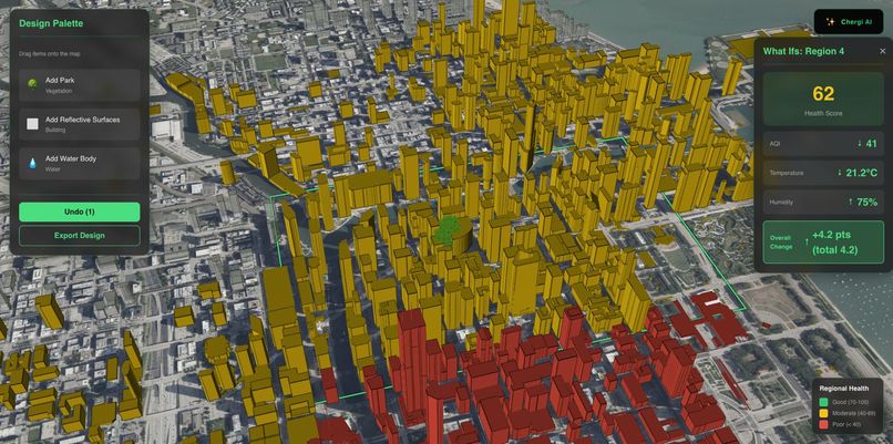
Main Screen


Chergi AI - NASA-Powered Healthy City Digital Twin
Inspiration
We were inspired by a simple idea: cities should be able to see the real impact of their decisions before they build anything. NASA collects world-class Earth data-heat, air quality, vegetation, night lights-but planners rarely get tools that turn this into clear, actionable insight.
Chergi AI was born from this gap. We wanted to turn raw satellite data into a visual, simulation-ready digital twin that helps improve human wellbeing and urban resilience.
What it does
Chergi AI creates an interactive 3D digital twin of a city using NASA data. It maps heat islands, air pollution, vegetation, infrastructure, and vulnerability.
Users can drag & drop interventions (new parks, clinics, cool roofs, traffic-reduction zones) onto the map. The system instantly updates metrics including:
- Land Surface Temperature
- NDVI and green access
- NO₂ exposure
- Healthcare accessibility
- Impacted population
- A real-time Healthy City Score
The Healthy City Score is calculated as:
$$ HCS = 100 - (w_h H + w_a A) + (w_g G + w_c C) $$
and the equity adjustment is:
$$ HCS_{eq} = HCS \cdot (1 - 0.4V) $$
The AI module then translates these changes into short, human-readable insights grounded in NASA science.
How we built it
- Data: MODIS & Landsat LST, Sentinel-2 NDVI, TEMPO/OMI NO₂, VIIRS night lights, SEDAC/GHSL population and vulnerability
- Backend: FastAPI for scoring, simulation, and raster tile generation
- Math model: Standardization, weighting, and dynamic recomputation of metrics
- Frontend: Next.js, Mapbox GL, and deck.gl for 3D visualization and drawing tools
- AI module: Converts numerical deltas into natural-language explanations using structure-aware prompts and the equations above
Challenges we ran into
- Cleaning and harmonizing multi-resolution NASA datasets
- Building a fast raster tiling system that renders smoothly in the browser
- Balancing scientific accuracy with real-time computational performance
- Designing a scoring model that is both intuitive and rigorous
- Ensuring AI explanations stay grounded in the actual math, not hallucination
Accomplishments that we're proud of
- A fully working NASA-powered city digital twin
- Real-time drag-and-drop planning simulations
- A transparent Healthy City Score with equity built in
- A smooth 3D UI that feels like a production planning tool
- A clear link between NASA Earth observations and human wellbeing
What we learned
- How to preprocess and tile NASA satellite data efficiently
- How environmental indicators like heat, vegetation, and pollution interact in cities
- How to design scoring systems that balance interpretability and rigor
- How to integrate AI explanations without losing scientific grounding
- How small interventions can meaningfully help vulnerable communities
What’s next for Chergi AI
- Expand to more cities with automated global preprocessing
- Add new interventions (solar rooftops, bus lines, EV corridors, reflective paving)
- Integrate real-time weather, smoke, and flood layers
- Release an open API for researchers and governments
- Extend the system toward Moon/Mars settlement planning, adapting the digital twin for future space habitats


Log in or sign up for Devpost to join the conversation.