-
-
BeaconAid
-
-
-
-

-


Inspiration
The California wildfires have grown into a major crisis, demanding more resources and coordinated efforts to protect lives. Many people want to help, but there’s no centralized hub to organize relief efforts. How can volunteers easily find where to donate supplies or lend a hand? What about during earthquakes, floods, or hurricanes? BeaconAid was born from this need—a platform that connects those seeking help with those ready to provide it.
What It Does
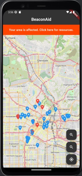
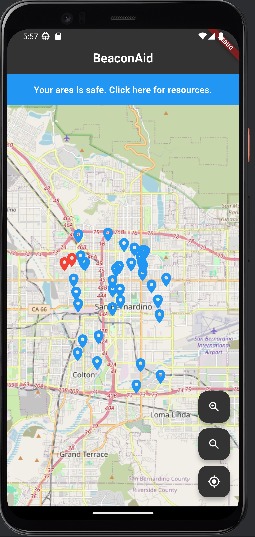
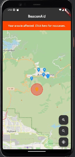
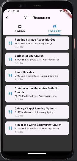
BeaconAid uses Flutter’s geolocation features to pinpoint a user’s location. It then pulls real-time data from the National Weather Service to identify nearby natural disasters and overlays them on an interactive map. Simultaneously, it locates essential resource centers like shelters, food banks, and hospitals using Google Maps. Users can tap on disaster zones to see how far they are and what supplies are needed. Likewise, tapping on resource centers provides details on available aid. Aside from serving users that near the disaster warning zone, BeaconAid also encouraged non-dangers individuals to participate and volunteer in multiple options, where point will be rewarded upon every volunteer act. By combining these features, BeaconAid serves as a real-time hub for disaster response and volunteer coordination.
How We Built It
We developed BeaconAid in Flutter to ensure accessibility across mobile devices, prioritizing fast load times and a smooth user experience. For real-time disaster tracking, we integrated APIs from the National Weather Service. Google Maps helps locate vital aid centers, and OpenPass assists in determining nearby cities. By blending these technologies, we created a reliable and user-friendly platform that brings critical information directly to those who need it. To saved and maintain the volunteers credentials and points status, we also deployed Firebase database that will store the username and the points that are accumulated.
Challenges We Faced
None of us had prior experience with Flutter or Dart, yet we chose them to maximize accessibility. Setting up Flutter, Android Studio, and emulators was a challenge, but learning the framework itself proved even more demanding. Additionally, integrating APIs was tricky—the National Weather Service alerts aren’t tied directly to cities, requiring us to devise a way to generalize affected areas. As a team of backend developers with limited frontend experience, designing an intuitive interface also took significant effort.
Accomplishments We’re Proud Of
Despite facing numerous technical and logistical hurdles, we successfully built a functional and impactful application. We adapted quickly, learned new technologies on the fly, and delivered a working product within a tight deadline. Overcoming these challenges and creating something meaningful is an achievement we’re incredibly proud of.
What we learned
We learned a lot about Flutter and an entirely new programming language called Dart. But besides just the tech stacks, we learned how to professionally communicate in a team of people you may have never met before and also how to execute thriving discussions to come up with amazing ideas built off of everyone's opinions and thoughts. These skills will stay with us throughout our professional career and we are glad to have had the opportunity to sharper these skills here at IrvineHacks.
What's next for BeaconAid
Currently, BeaconAid is limited to the U.S. due to its reliance on the National Weather Service. In the future, we aim to expand globally, incorporating international disaster response data to help communities worldwide. We also envision a strong, connected network of volunteers who can coordinate relief efforts and maximize aid distribution.
Built With
- android-studio
- api
- dart
- fire
- firebase
- flutter
- google-maps
- nationalweatherservice
- openpass


Log in or sign up for Devpost to join the conversation.