-
-
branding
-
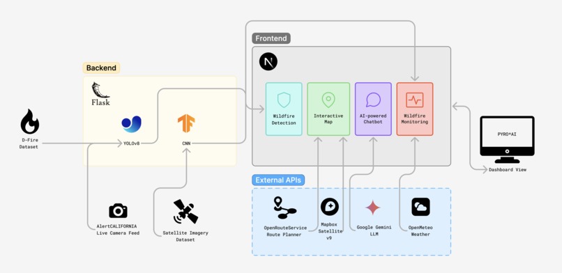
high-level overview of architecture


Inspiration
Not so long ago in January 2025, the Palisades and Eaton fires took over Los Angeles and global headlines, consuming over 37,000 acres, destroying more than 16,000 structures, and tragically claiming at least 29 lives. As this event unraveled, we recognized the need for smarter, more sustainable wildfire management systems that prioritize safety and empower communities to act swiftly.
That's why we built Pyro.AI—a centralized wildfire monitoring dashboard designed to protect lives, safeguard ecosystems, and foster resilience against climate-related disasters. Our dashboard extends beyond existing platforms like Watch Duty by offering tools tailored to real-time wildfire detection, risk assessment, and evacuation planning.
What it does
- Automated Evacuation Planning
- Identifies the safest and most efficient routes from danger zones to ensure timely evacuations.
- Fire Detection Using Camera Feeds
- Utilizes real-time camera feeds integrated with a Yolov8 model trained on the D-fire dataset to detect wildfires with high accuracy. This feature allows users to toggle detection on or off as needed, providing flexibility and control.
- Intelligent Chat System for Safety Insights
- A personal wildfire guide powered by Google Gemini, offering real-time safety insights. By ingesting live environmental data—such as air quality, temperature, wind speed, and humidity—it provides actionable recommendations tailored to users' locations, helping them make informed decisions during emergencies.
How we built it
Our development process began with a critical question:
How might we provide real-time wildfire detection, risk assessment, and automated evacuation planning to ensure users are informed, educated, and empowered to act swiftly during wildfire emergencies?
Which helped us devise 3 core hypotheses:
Hypothesis 1: Real-time Wildfire Detection and Risk Assessment
How might we develop an integrated system that combines real-time wildfire detection with accurate risk assessment to provide timely and actionable information to emergency responders and the public?
Hypothesis 2: Automated Evacuation Planning and Route Optimization
How might we create an automated evacuation planning system that optimizes routes and provides personalized guidance to ensure swift and safe evacuations during wildfire emergencies?
Hypothesis 3: Real-time Information Platform for Wildfire Preparedness and Response
How might we design a platform that delivers real-time news, updates, and educational content to effectively inform and prepare users for wildfire emergencies, leading to improved response and outcomes during actual events?
Prototyping Process
To explore these hypotheses, we wanted to quickly build a functional prototype. We acknowledged that one of the major pain points of product development is the gap between ideation and implementation. Because of this, we decided to utilize Lovable.dev due to its 3 core advantages:
- Rapid Transformation from Idea-to-Prototype
- Instantly translate brainstorming sessions and concepts into an interactive and functional prototype with just a few prompts.
- Deployment in just a single click to validate and test our ideas with ease.
- Full Stack Development Without Technical Barriers
- Live rendering for immediate visual feedback.
- Select-to-Edit functionality for precise component modifications.
- AI-assisted debugging and code refinement.
- Iterative Development with AI Assistance
- Make quick adjustments in natural language based on user feedback.
Competitive Analysis
Next, to thoroughly explore our problem space, we conducted a Competitive Analysis of Watch Duty to identify opportunities and limitations in addressing real-time wildfire detection, risk assessment, and evacuation planning.
Watch Duty is a free, nonprofit wildfire alert app that provides real-time updates through vetted data from firefighters, dispatchers, and first responders.
Strengths
- Provides accurate, real-time wildfire detection through human-vetted updates, ensuring reliability during emergencies.
- Offers detailed evacuation zones and shelter information to support informed decision-making during crises.
- Integrates satellite imagery (VIIRS/MODIS) for fire tracking and risk assessment.
Limitations
- Lack of centralized predictive tools for fire spread modeling and automated risk assessment.
- Limited user notification scope (up to four counties), reducing coverage for those monitoring multiple regions.
- Absence of automated evacuation route optimization, relying on manual updates instead.
Opportunities
- Develop predictive fire spread models to enhance real-time risk assessment capabilities.
- Introduce automated evacuation planning with route optimization to improve user safety and response time.
- Expand notification capabilities to allow broader regional monitoring for users in high-risk areas.
Research Process
What was another important aspect was conducting a mixed-method research approach combining primary and secondary research methods to gain a holistic understanding of user needs, behaviors, and challenges related to wildfire detection, risk assessment, and evacuation planning.
Primary Research
We conducted 1:1 qualitative interviews with five Los Angeles residents who directly experienced or were in close proximity to the January 2025 Palisades and Eaton wildfires. These interviews aimed to uncover firsthand experiences, emotional responses, and unmet needs during wildfire emergencies.
Key insights:
- Information Overload: Participants described feeling overwhelmed by fragmented information from multiple sources (news outlets, social media, government alerts).
- Delayed Notifications: Many reported receiving evacuation orders too late or relying on word-of-mouth updates from neighbors.
- Evacuation Challenges: Interviewees highlighted confusion about safe evacuation routes due to unclear or outdated maps, leading to heightened anxiety during emergencies.
Secondary Research
We conducted an extensive literature review focusing on wildfire management systems, emergency response technologies, and user behavior during natural disasters. This included academic papers, government reports, and case studies on recent wildfire events.
Key findings:
- Real-Time Data Gaps: Current systems often lack integration of real-time fire spread models with actionable risk assessments for users.
- Evacuation Route Optimization: Studies emphasized the importance of dynamic route optimization tools that adapt to changing fire conditions to reduce evacuation delays.
- User-Centric Design: Research highlighted the need for accessible interfaces that prioritize clarity and usability under high-stress conditions.
How We Built It
After collectively ideating and thoroughly exploring our problem space, to finally test our hypotheses we integrated advanced technologies and APIs to deliver a comprehensive wildfire management system.
Automated Evacuation Planning
- We utilized OpenRouteService (ORS), a highly customizable routing API, to calculate the safest and most efficient evacuation routes.
- ORS's features, such as avoiding hazard zones using the "avoid_polygon" parameter, were critical for dynamically rerouting users away from wildfire-affected areas.
- The system integrates real-time environmental data from APIs like openmeteo to account for changing weather conditions and fire spread patterns, ensuring routes are always updated.
Fire Detection
- Fire detection is powered by a YOLOv8 model, a state-of-the-art object detection algorithm trained on the D-fire dataset. This allows for high-accuracy detection of fires and smoke in real-time camera feeds.
- We integrated live camera feeds like AlertCalifornia Videos, enabling users to toggle fire detection on or off for enhanced situational awareness.
Readily Accessible Information via Chat System
- The chat system is built using Google Gemini, which processes real-time environmental data such as air quality, temperature, wind speed, and humidity.
- By combining this data with safety insights, the chat system provides users with actionable recommendations tailored to their specific location and circumstances.
Wildfire Monitoring Dashboard
The dashboard consolidates critical information into an intuitive interface:
- Air Quality Index (AQI): Data is sourced from openmeteo and processed to display localized AQI levels.
- Safety Score & Wildfire Risk Level: These metrics are calculated using a mathematical formula that combines environmental factors (e.g., temperature, wind speed) with fire spread predictions from our CNN model.
- Mapbox v9 Satellite Integration: Real-time satellite imagery is displayed using Mapbox's API, offering users a clear view of wildfire locations and affected areas.
Machine Learning Models
A Wildfire Convolutional Neural Network (CNN) was trained on satellite imagery data to predict wildfire risk levels and fire spread patterns.
- The model architecture includes convolutional layers optimized for spatial data analysis, enabling accurate predictions based on environmental conditions.
Tabs and Features
- Alerts Tab: Displays categorized updates (e.g., "All," "Alerts," "General," "Shelters") sourced from reliable APIs like openmeteo and Google Gemini.
- Routes Tab: Integrates automated evacuation routing powered by OpenRouteService to guide users safely out of danger zones.
- Chat Tab: Provides real-time safety insights and answers user queries through Google Gemini's AI capabilities.
News & Updates Integration
The dashboard aggregates wildfire-related news and updates into categories like "All," "Alerts," "General," and "Shelters," ensuring users stay informed during emergencies.
APIs Used
- Mapbox: For satellite imagery and map-based visualizations of wildfire locations.
- Google Gemini: Powers the intelligent chat system for safety insights.
- openmeteo: Supplies real-time environmental data such as air quality, weather conditions, and wind speed for risk assessment and evacuation planning.
Challenges we ran into
Our development process faced several technical hurdles:
- Backend-frontend integration complexities when connecting our Flask server with the React frontend, particularly for real-time data updates
- Implementation challenges in calculating accurate wildfire risk scores that incorporate multiple environmental factors
- Deployment difficulties with our backend system due to TensorFlow package dependencies and compatibility issues
Accomplishments that we're proud of
We successfully developed essential features that make a meaningful social impact:
- Created a comprehensive wildfire monitoring system that helps protect communities and ecosystems
- Implemented real-time fire detection and risk assessment capabilities
- Developed automated evacuation planning tools that can help save lives during emergencies
What we learned
- Our development journey gave valuable insights into firsthand experience in the importance of usability testing and continuous user feedback for improving our platform
- We also discovered the effectiveness of rapid prototyping tools like Lovable.dev in accelerating development and validation of ideas
What's next for Pyro.AI
Looking ahead, we plan to refine our core feature--automated evacuation planning by:
- Implementing multi-point evacuation routing to handle large-scale evacuations more efficiently
- Enhancing the OpenRouteService integration to account for real-time traffic conditions
- Developing backup route suggestions for scenarios where primary routes become compromised
As well as evacuation zone management:
- Expand the safety scoring system to provide more granular risk assessments for different areas
- Improve danger zone calculations using more sophisticated geometric algorithms
- Enhance the visualization of evacuation zones in the MapboxMap component


Log in or sign up for Devpost to join the conversation.