-
-

-
-

Whisper Grid Logo


WhisperGrid
🌄 Inspiration
Safety. Hiking can be unpredictable, especially when you’re on unfamiliar trails or hiking solo. We wanted to create something that keeps hikers connected, informed, and safe — giving peace of mind to both them and their loved ones.
🛰️ What it does
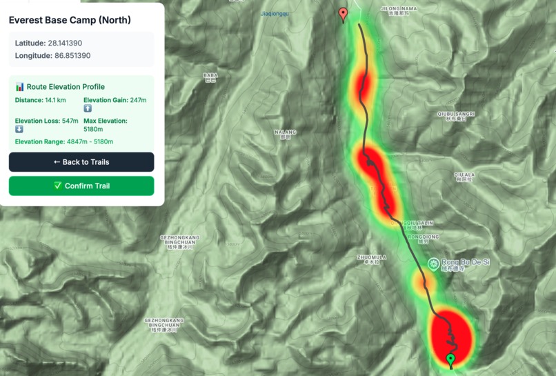
- Trail selection: Users can easily select from available hiking trails.
- Trail stats: Displays average completion time ⏱️, distance 📏, and elevation change ⛰️.
- Safety check-ins: Users can set how often the app checks in and how long before emergency contacts are alerted if there’s no response.
- Emergency response: When emergency contacts are notified 🚨, they receive a heatmap showing the hiker’s most likely location — based on their last known position, time since last contact, and the difficulty of different trail sections.
🛠️ How we built it
We used a combination of Google Maps API features to:
- Gather and display key trail information
- Create maps, pins, and routes between points
- Calculate elevation changes
- Generate the heatmap for emergency responders
We also used the OpenAI API to provide insights about selected hiking trails, making the experience both safe and engaging.
⚡ Challenges we ran into
- Building an intuitive map UI 🗺️
- Ensuring reliable hosting
- Navigating the Google Maps API for the first time
🏆 Accomplishments we’re proud of
- A smooth, functional prototype that works exactly as envisioned.
- The heatmap tool — an innovative way to assist emergency contacts and authorities in locating hikers faster.
- Creating a user-friendly flow where all features work together seamlessly.
📚 What we learned
We discovered just how much the Google Maps API can do — and we’ve only scratched the surface. There’s massive potential for building even more robust tools using its capabilities.
🚀 What’s next for WhisperGrid
- Live location tracking 📍
- User accounts (to securely store emergency contact information)
- Partnerships with park rangers and trail supervisors to integrate directly with rescue services
- Making the app more robust for offline use in low-signal areas
Built With
- googel-maps-api
- google-maps-platform-api
- html
- javascript
- openai-api


Log in or sign up for Devpost to join the conversation.