This is the “legacy” or archive FOX12 weather blog site.
POSTS MAY BE WEEKS OR A MONTH OLD
Nowadays I post to our station website, then, when I have time, I copy the post to this site. Since this is a simple copy/paste, you’ll notice formatting errors, or extra large/small text. You also can’t click on most images to take a closer look. I strongly encourage you to bookmark/use this site: https://www.kptv.com/weather/blog/
Thanks for reading all these posts for the past 20 years, can you believe the first post was late November 2005?
Comments Off on Weather Blog Note | Weather | Permalink Posted by Mark Nelsen
March is sure looking…typical! “Typical” for this region means lots of clouds, showers or steady rain at times, and temperatures moving up and down each day. Some days are warm and partly cloudy, others feature chilly showers with snowflakes down into the hills.
You may have seen somewhere on social media that snow may be on the way in the lowlands? No, sticking snow is even less likely than two weeks ago (when it didn’t happen for most of us), so don’t get excited about that. That said, it’s possible some of us see snowflakes mixed in again Monday evening through early Tuesday. But that’s it. I’d be surprised if I pick up more than 1/2″ snow on my lawn Tuesday morning…at 1,000′.
High pressure is pushing north across the region this Friday evening, but it’s just barely enough to push rain out of the area for just one day…Saturday.
(kptv)
By Sunday, the high is weakening, and wetter westerly flow is approaching.
Sunday(kptv)
Next Wednesday, the 11th, westerly flow is aiming an atmospheric river (especially wet system) right at the Pacific Northwest
(kptv)
As one dip (trough) in the jet passes through Monday and Tuesday, the atmosphere cools quite a bit, bringing at least 6-10″ snow to the Cascades and sticking snow down around the 1,000-2,000′ elevations. But showers will be very light when the cool air is here, so it’ll be tough to get sticking snow down below 1,000′ anywhere except in the Coast Range (where it’s “wetter”). Take a look at the big dip in the snow level later Monday and Tuesday.
Snow level forecast(kptv)
For the geeks, we’re talking -6 to -7 850mb temperatures during this time. In early-mid March, with onshore low-level flow, we need -8 or -9 to get any real sticking snow to the lowest elevations in this showery pattern.
You can see models agree, showing little or nothing in the lowest elevations. This is the Horizon A.I. model from ClimaVision.
(kptv)
Speaking of snow, mountain snowpack is still terrible across the region. Right now it’s still the 2nd lowest snowpack on record statewide in Oregon. Other than a period of snow the middle of next week, I don’t see a cold/snowy pattern in the next 10 days.
Courtesy: USDA(kptv)
Check out total snow forecast for around 4-5,000′ on Mt. Hood from the Euro ensembles for the next two weeks…one nice period of heavy snow Wednesday-Friday next week. The bars are the ensemble average snow accumulation. The blue line is just the “control run”, one of the 50 ensemble members. We used to call that the operational run.
EURO Snow accumulation next two weeks(kptv)
Could we really get 2 feet of snow up there next Wednesday-Thursday? Possibly, assuming the atmospheric river during that time is cold enough and shifts far enough south into northern Oregon. Time will tell; this winter we’ve seen several times where models forecast heavy and cold precipitation and then as the event approaches there is less moisture and it’s not as cold.
SUMMARY (I-5 CORRIDOR & COASTLINE)
Saturday is the only guaranteed dry day in Portland over the next week.
Showers on Sunday will be very light, and might not arrive until midday. But it will be a gloomy/gray day.
Very light showers follow with sunbreaks Monday and Tuesday
Any showers falling overnight Monday night until about 10am Tuesday could be mixed with snow in the lowest elevations. Although that’s more likely in the higher hills. Temperatures rise into the mid-upper 40s Tuesday afternoon.
Widespread overnight freezing is unlikely in the next week in the western valleys.
Heavier rain (a widespread 1″+ soaking) is possible around next Thursday/Friday.
I was just out trimming some bushes this morning in the warm-ish sunshine. I see lots of buds out and realized…we probably aren’t going to see a significant freeze this winter. Time is running out for that. There’s still some time left to get snow of course. Just three years ago we had our biggest February snowstorm on record later in the month.
THE HIGHLIGHTS
1) There’s no sign of an “arctic blast” in the next 10 days. That means high temperatures at/below freezing in western OR/WA and lows in the teens or lower.
2) It will turn a bit cooler next week with snow levels at least down to 2,000′ at times. At this time I don’t see a setup that would bring sticking snow lower than 1,000’ in the next 10 days (through the 21st).
3) There are hints that we stay cool-ish with wet at times until the last few days of February. That’s why it would be ridiculous to bring out a fork and say “winter is over”. An early morning wet snowfall can occur in this setup.
RIGHT NOW
Do you realize Portland hasn’t even had a day this winter in which the temperature stayed in the 30s? That’s very mild. On New Year’s Day, PDX only made it to 41 degrees, no other day was that “cold”. That’s very mild for wintertime here. By the way, that ties three other years in which the winter (coolest) daytime high was so mild. 1967 and 2003 had the same number.
Portland did drop to 22 back in late January. That’s likely going to be the low temperature for the winter.
(kptv)
And it’s still (just barely) the warmest winter on record in several parts of the region.
(kptv)
There was a minor “snowstorm” last weekend in the Cascades, but it didn’t help much. 6 Cascade ski areas are closed and three are open…HEADING INTO MID-FEBRUARY! Right now, Oregon’s snowpack is the worst on record (back to early 1980s). We do know that winter 1976-1977 was a bit worse.
Worst snowpack in decades in Oregon(kptv)
WHAT’S AHEAD?
The strong high pressure that has kept weather systems out of the western USA much January has weakened. But now it has been replaced by a “split-flow”. That means weather systems moving through the eastern Pacific tear apart; some goes south into California and some goes north. In this setup we tend to get very weak storms systems or even just scattered showers at times. You can see that split in tonight’s 500 millibar height chart
Right now(kptv)
It’s still there on Sunday (the 15th)
(kptv)
So the pattern doesn’t change much over the next week, but the troughs dropping down the west coast of North America turn a bit cooler. Check out the 850mb temperature forecast from the ECMWF model ensembles. The “zero” line is freezing at pass elevation, that’s in yellow. Time goes from left to right, right now to two weeks from now. Notice much of the time (starting this weekend) the freezing line will be at/below the passes. The solid green line is the ensemble average…follow that.
(kptv)
That chart tells me that we’re headed into a normal to cooler-than-normal period. When the 850mb gets down to -5 or lower, that’s when we watch closely to see if snow could stick down to 1,000′ or lower. Notice it gets close to that a couple of times with some individual members (the “whiskers”) down below -5. So, something to keep an eye on, but right now I’m not thinking “it looks like wet snow sticking down to sea level”.
Why do I think we’ve escaped without a major arctic freeze this winter? It’s because mid-February is about that latest we have seen a significant freezing event west of the Cascades. Take a look at Portland’s record highs/lows for February. For the purposes of defining an “arctic blast”, I’d consider that a high temperature of 33 or lower and/or a low at/below 15 degrees. The first is more important for our lives. If it’s 20 at night but only 30 during the day…the city stays frozen. But if it’s 18 at night and 45 during the day, no biggie and life continues.
Portland weather stats(kptv)
You can see how (historically) the really cold stuff disappears after Valentine’s Day or so. We sure don’t see it in the next 7-10 days either. So I think we’re in the clear for that this season. This will be the 2nd year without a significant arctic freeze. But as for snow? That could easily still happen; although it’ll take a major pattern change for that to occur. Notice the chance for 1″ of snow or more in the city drops quickly as we head into late February.
Late season snow chances(kptv)
The chance for 1″ in the city goes very low once we hit March 1st. Yes, it CAN snow in March, and even snowed ONCE in April (at PDX), but it’s rare.
That’s all I’ve got for this evening. As I’ve mentioned this winter, we’re really pushing more into the digital world and producing far more content than in the past. That means nowadays I’m generally publishing written blog posts like this only for severe/stormy/snowy/icy weather events. OR, if it’s really boring and the last post was 2-3 weeks ago.
If you are reading this, you likely have a strong interest in weather. Let me introduce two additional ways to get detailed weather information. Not A.I. slop and not automated, we spend a lot of time on these and enjoy producing them. Check them out!
Did you know we are recording a DAILY (most weekdays) weather show at KPTV? I’m not aware of any other station in our area doing this. It’s typically 12-30 minutes of detailed weather information from our meteorologists. We take a deep dive into explainers and data that we sure don’t have time for on regular broadcast TV. Basically we have all the time in the world to talk about weather! Find old episodes here on our web page:
These are LIVE at 7 p.m. on our FOX 12 OREGON streaming app. You add that on your Roku, Amazon Fire, or SmartTV. I know, seems complicated, but it’s just another little app right beside your Netflix, Amazon, HBO, etc… apps. That’s how mine is set up at home. These are on the web page typically by 8 p.m. or so if you can’t watch live.
It’s still going strong! We record an episode most Wednesdays at 7 p.m., full of detailed weather information and a few laughs. We typically stream it live at the same time on our FOX 12 WEATHER Facebook page so that you can ask questions too. Within about 1.5 hours it’s on our web page (and app) here:
January is wrapping up this week, and I’m starting to hear the same three questions
1) When is a regular snowy/cold pattern going to arrive in the Cascades?
2) When will it snow in the valleys?
3) Is this it for winter?
Of course I’ve got a few thoughts on all three. For those of you with a short attention span, the answers:
1) There is no cold/snowy/normal weather pattern in sight for the Cascades, at least through the first week of February. The low-mid elevations (below 6,000′) will likely lose more snow than they gain over the next 10 days. That’s why I went skiing in the sunshine this weekend, still had a great time in comfortable temps and calm wind!
2) There is no sign of a cold/snowy weather pattern for the lowlands west of the Cascades through at least the first week of February. Sure, something might be up that we don’t know about somewhere in mid-late February, but we can’t see that far out.
3) See #2. In fact, we are headed the opposite (warmer) direction. There are strong signs that we’ve got some “false spring” weather incoming during the first week of February. Possibly afternoon highs up around 60° or so in spots not exposed to the chilly easterly Gorge wind.
WARMEST WINTER ON RECORD…SO FAR
We haven’t really had a “winter” so far in the lower elevations of western Oregon and SW Washington. Sure, some cold temps at night over the past week or so, but until that time some parts of Portland still hadn’t seen a frost. Right now, PDX is running just barely ahead of 1950-51 and 2020-21 for warmest winter on record.
Yet, the almost constant inversion (warm mountains, cold valleys) most likely gave us the coldest morning of winter on Sunday. Unless we get some sort of late-season arctic air in mid-late February, there’s a very good chance 22° will be the “winter low” at PDX.
(kptv)
Of course Cascade snowpack is terrible right now. Timberline Lodge spent 11 consecutive days without touching the freezing point. Here’s Oregon:
Low snowpack in PACNW(kptv)
And Washington, only doing well near Canadian border (good for Columbia River this summer).
Low snowpack in PACNW(kptv)
WHAT’S AHEAD?
The strong high pressure that has kept weather systems out of the western USA the past 2-3 weeks has broken down early this week. Good news right? Nope, it’s just going to stay weak for a few days, then bounce back next week in one form or another. It’ll remain near/over the West Coast through the next 10+ days.
Check out the 500 millibar chart right, a “dirty ridge” over the region. Weak weather disturbances (clouds and light precip) can move over us with this pattern; in fact some of you saw sprinkles or a shower today.
(kptv)
On Wednesday a big “dent” in that ridge, we actually get widespread light rain late Tuesday and Wednesday for the first time in almost 3 weeks!
(kptv)
We stay in this general setup with a few weak-ish systems passing nearby or overhead through this coming weekend. But then ridging turns stronger again. The next chart below is the 500 millibar anomaly for 9 days from now. Models in pretty good agreement through this point. Typically we’d be under a strong inversion in this setup…yes, the chilly east wind will come back. BUT, in early February the sun is getting stronger and it’ll be easier to get warmer temperatures away from the Gorge. We could see sunshine and widespread 50s in this setup. Mountains will be VERY warm.
(kptv)
So even though we’ll get some rain at times (and a little mountain snow) the next 10 days, it’ll still be drier than typical for this time of year. You can see where some pineapple express events will dump wetter conditions at times up to the north on this chart, yet the 15-day anomaly for precipitation is strongly negative from Oregon southward.
10-Day precip anomaly(kptv)
Sure, at times there will be a few inches of snow down to 5,000′ or so in the mountains, but nothing substantial. The Euro ensemble average snowfall for the next 10 days is minimal.
(kptv)
A bigger issue for the mountains: now that clouds and some light precip returns, it’ll be much easier for the existing snowpack to soften up and melt. It’s those sunny days and long, clear nights that have preserved that 2-3′ snowfall we had 3 weeks ago. The 850 millibar temperature chart from the GFS tells the story with the warm temps ahead in the mountains. Green line is average temperature from today (left) to two weeks out (right). You want temperatures at pass elevation (yellow horizontal line) to be at zero or below (celsius). Notice almost the entire time the next 10+ days it’ll be above freezing at pass elevations. The next hint of a possible change is around the 8-12th of February IF the ridge backs off to the west a bit and allows a cooler northwest flow to return. Otherwise…there’s no great hope for a turnaround at ski areas through the first week of February.
(kptv)
That’s all I’ve got for today. As I’ve mentioned this winter, we’re really pushing more into the digital world and producing far more content than in the past. That means nowadays I’m generally publishing written blog posts like this only for severe/stormy/snowy/icy weather events. OR, if it’s really boring and the last post was 2-3 weeks ago.
If you are reading this, you likely have a strong interest in weather. Let me introduce two additional ways to get detailed weather information. Not A.I. slop and not automated, we spend a lot of time on these and enjoy producing them. Check them out!
Did you know we are recording a DAILY (most weekdays) weather show at KPTV? I’m not aware of any other station in our area doing this. It’s typically 12-30 minutes of detailed weather information from our meteorologists. We take a deep dive into explainers and data that we sure don’t have time for on regular broadcast TV. Basically we have all the time in the world to talk about weather! Find old episodes here on our web page:
These are LIVE at 7 p.m. on our FOX 12 OREGON streaming app. You add that on your Roku, Amazon Fire, or SmartTV. I know, seems complicated, but it’s just another little app right beside your Netflix, Amazon, HBO, etc… apps. That’s how mine is set up at home. These are on the web page typically by 8 p.m. or so if you can’t watch live.
It’s still going strong! We record an episode most Wednesdays at 7 p.m., full of detailed weather information and a few laughs. We typically stream it live at the same time on our FOX 12 WEATHER Facebook page so that you can ask questions too. Within about 1.5 hours it’s on our web page (and app) here:
After some briefly wild weather in December, and one mountain snowstorm this month, a calm weather pattern has returned.
WARMEST WINTER ON RECORD…SO FAR
You aren’t crazy, we haven’t really had a “winter” so far. Most of us in the metro area have only seen upper 20s or even 32 degrees a few times. Parts of central/southeast/east metro still haven’t dropped below freezing! I think it’s most interesting that even some small towns are seeing the warmest winter on record; clearly it’s not an “urban heat island” thing going on.
(kptv)
Check out the record number of 50° days at several Oregon weather stations. By the way, much of the western USA is experiencing the warmest winter on record so far.
Last week’s 2-3 feet of snow in the Cascades finally allowed all ski areas to open up, but snowpack is still very thin for this time of year. The entire region is far below normal for mid-January
(kptv)
WHAT’S AHEAD?
We’ll be staying dry through Tuesday the 20th, possibly longer.
Strong high pressure overhead the next few days means any area about about 2,000′ west of the Cascades will turn very warm through at least Saturday. The coastline should get well into the 60s on Friday and Saturday too.
Yet cool air stuck in the lowest elevations west of the Cascades means we’re entering a multi-day period of low clouds and fog from Salem down to Eugene.
The Portland metro area gets enough (strong) east wind Thursday through the weekend to keep fog away most of the time. But that wind will be chilly!
East wind turns very strong Friday and Saturday. Gusts 40-50 in the usual spots east metro near the Gorge and 80+ in the western Gorge.
Luckily the Cascade snowpack won’t melt too much due to short days and low sun angle, but it’ll continue to “consolidate” (turn into a slushy/icy block).
A blocking ridge of high pressure keeps weather systems from moving into the Pacific Northwest for another week. You may recall this happened last January too with an 18 day stretch of dry weather and multiple sunny days.
(kptv)
Check out that monster sitting almost right over the West Coast on Friday!
(kptv)
When does the ridge of high pressure fall apart and when will rain resume? Checking out the 50 ensemble members of the Euro, it’s pretty clear that rain returns somewhere between next Tuesday and Thursday. Lots of green showing up at that time and continuing through the weekend of the 24th/25th.
Euro Precip Forecast(kptv)
That’s all I’ve got for this evening. As mentioned a month or so back, we’re really pushing more into the digital world and producing far more content than in the past. That means nowadays I’m generally publishing written blog posts like this only for severe/stormy/snowy/icy weather events. OR, if it’s really boring and the last post was 3 weeks ago.
If you are reading this, you likely have a strong interest in weather. Let me introduce two additional ways to get detailed weather information. Not A.I. slop and not automated, we spend a lot of time on these and enjoy producing them. Check them out!
Did you know we are recording a DAILY (most weekdays) weather show at KPTV? I’m not aware of any other station in our area doing this. It’s typically 12-30 minutes of detailed weather information from our meteorologists. We take a deep dive into explainers and data that we sure don’t have time for on regular broadcast TV. Basically we have all the time in the world to talk about weather! Find old episodes here on our web page:
These are LIVE at 7pm on our FOX12 OREGON streaming app. You add that on your Roku, Amazon Fire, or SmartTV. I know, seems complicated, but it’s just another little app right beside your Netflix, Amazon, HBO, etc… apps. That’s how mine is set up at home. These are on the web page typically by 8pm or so if you can’t watch live.
It’s still going strong! We record an episode most Wednesdays at 7pm, full of detailed weather information and a few laughs. We typically stream it live at the same time on our FOX12 WEATHER Facebook page so that you can ask questions too. Within about 1.5 hours it’s on our web page (and app) here:
It’s been an exciting 10 days, but now the weather has calmed down and should stay that way through Christmas.
WARMEST DECEMBER ON RECORD…SO FAR
When we look back at December, the story will be “wet and warm”. As of the 18th in Portland, it’s the warmest on record in Portland
Portland is running 8.7 degrees above normal
Rainfall is well above average; it’s the 5th consecutive wet December
No ski areas are able to fully open in the Cascades for this first weekend of the two-week Christmas Break. In fact only the Bruno lift at Timberline will be open this weekend.
Mild temperatures should continue through at least the weekend after Christmas. Not record-breaking warm, but near/above normal.
Showers continue this next week, but a “splitty” jet stream keeps the deep, stormy, low pressure systems away from us.
Check out the high temps this month in Portland. Warm!
(kptv)
But with all the cloud cover and southerly wind, the lows really stand out. Those with yellow outline are new record warm lows. Not a single below average low except for the 1st. In fact that’s the only freezing temperature we’ve seen. A good chunk of the inner metro area has yet to see a killing frost!
(kptv)
Yep…it’s been wet too. Over 7″ so far this month and more on the way
Another very wet December(kptv)
Almost all rivers are now receding in the region, but the flooding on the Sandy, Clackamas, and Molalla was the highest we’ve seen in many years
Flooding comparison(kptv)
Yesterday’s rainy system (atmospheric river) rode over a cooler airmass trapped east of the Cascades in north-central Oregon and the Gorge. The result was astounding rainfall totals. The Dalles recorded the wettest day on record! You folks only average 13-14″ of rain each year.
New rain record(kptv)
Of course let’s not forget the bizarre westerly windstorm Tuesday night too. Models forecast an abrupt change to a gusty west wind around 1am early on the 17th. And it happened. But what a difference wind direction makes! A peak gust of 55mph was strong at PDX, and most other metro locations were below that speed. Yet 170,000 PGE customers lost power, ~15% of all customers. Plus widespread outages in Clark county too. Clearly our trees are not used to a strong west wind, especially with saturated soil
Peak wind gusts December 17th(kptv)
This has got to be one of the top 3 westerly wind storms I’ve seen in my 3 decade career. Those 50+ gusts up in the Hoodland Corridor from Welches to Government Camp caused so much destruction. A gust of 66 mph is “top tier” at The Dalles too.
Peak wind gusts December 17th(kptv)
WHAT’S AHEAD?
Sorry kids, no Christmas snow. Those snow levels will generally be in the 3,000′-5,000′ range over the next week.
The cool-ish westerly flow over us right now will buckle Sunday and beyond as a deep trough digs off the West Coast. That splits the jet a bit, sending more storm energy into California. Here’s the 500 millibar flow on Christmas Day. This is not a very exciting weather pattern for PACNW meteorologists…
(kptv)
I think ski season won’t be starting with a bang this season, but will gradually limp to the starting line. With the scattered snow showers forecast much of the time between now and Christmas, we’re sure not going to see the 3-4′ we need to open widespread terrain. We’ll be lucky to see 2′ between now and Christmas. Check out the ECMWF model’s forecast through “Boxing Day”.
Euro Snow Forecast(kptv)
Enjoy the calmer weekend and all of Christmas Week!
Thanksgiving week is here and it’s going to be a soaker! We’ve got an atmospheric river aiming at the region later tomorrow through Wednesday, then a low-pressure center that tracks right overhead on Thanksgiving Day. That adds up to…wet.
THE HIGHLIGHTS
Light rain arrives mid-late morning Tuesday
From that point through Wednesday, it’ll be raining most of the time west of the Cascades. No, you won’t see sunshine during this time – gloomy, gray, and dark is the story.
Expect up to 1.50″ through early Thanksgiving Day
Another surge of rain brings up to 0.50″ Thanksgiving afternoon/evening. That’s a total of 2″ in the next 3 days.
Black Friday and beyond, we head into a slightly cooler pattern with just occasional showers; some dry days too.
There’s no sign of an arctic blast through the first few days of December (or lowland snow), but it’s a weather pattern we’ll be watching closely. You should too!
So far this month, we’re running just a bit drier than average
Rain totals so far in November(kptv)
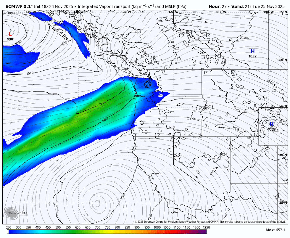
But don’t you worry, we’re going to make up that slight deficit the next 3 days. Here’s a loop of “water vapor transport” from Tuesday morning through Thanksgiving evening; about 2.5 days of time passes here
Tuesday morning through Thanksgiving evening(kptv)
It’s a steady rain tomorrow and much of Wednesday, then more off/on rain Thursday. You can see the surface low pressure center tracks right overhead Thursday. If so, maybe some downpours? Regardless, 3-day rain totals are likely going to be in the 1.50-2.00″ range. Our evening GRAF model is a bit juicier now
(kptv)
Yet at no time does it look like heavy rain. 3-hourly amounts never get up to 1/2″, a bit of a threshold I’m always looking for
(kptv)
Unfortunately, we only briefly see snow in the Cascades tomorrow down to about 4,000′, then it’s back to rain all the way up to 7,000′ late tomorrow through Thanksgiving. There won’t be any Thanksgiving skiing this weekend, although Skibowl’s tubing hill WILL open on Black Friday. I believe they make snow inside a refrigerated truck, then blow it out on the slopes. So snow-making occurs at temperatures well above freezing up there.
BEYOND THANKSGIVING INTO EARLY DECEMBER
Temperatures turn cooler starting next weekend, both days and nights
On clear nights with calm wind, widespread (and overdue) frosts should finally show up. Temperatures 25-32°
Cold arctic air remains east of the Rockies through at least early next week.
There’s a good chance there still won’t be enough snow for skiing the first weekend of December, BUT, maybe a much snowier pattern just beyond? Maybe.
A pattern change is going to show up. The setup later this weekend and through the first week of December is classic La Niña. Some sort of upper-level ridging offshore, then weak waves of energy coming down the “back side” (east side) of the ridge. If the “shortwave” moves offshore, we get showers and chilly weather, possibly followed by cold northerly flow at the surface. If far inland, temperatures remain near normal and we stay dry. Here’s an example. Saturday afternoon, a wave moving through.
Saturday afternoon(kptv)
Another one Tuesday…these maps are from the GFS model
Tuesday(kptv)
This pattern causes havoc among models because a slight change in where upper-level troughs dip into the region has major implications on our weather. One model shows an arctic blast, but another model (or ensembles from that same model) keeps troughs moving along and doesn’t drag arctic air south. The (regularly cold) GFS model was giving us an arctic blast for 1-3 days late last week through Saturday. It finally gave up on that idea yesterday. One big reason we use ensembles (many different versions) of any one model; it avoids the heartache of calling for a big arctic blast and then two days later saying “oh, sorry, that’s not gonna happen”.
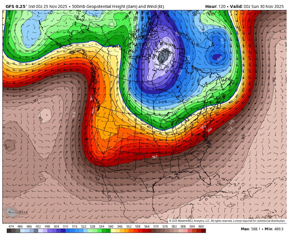
If you look at the day 1-6 average from the Euro ensemble average, you see the above normal heights offshore (ridging) and troughing to our east
(kptv)
Then days 6-11…next week. Not much change. Coldest air into the middle of the USA.
(kptv)
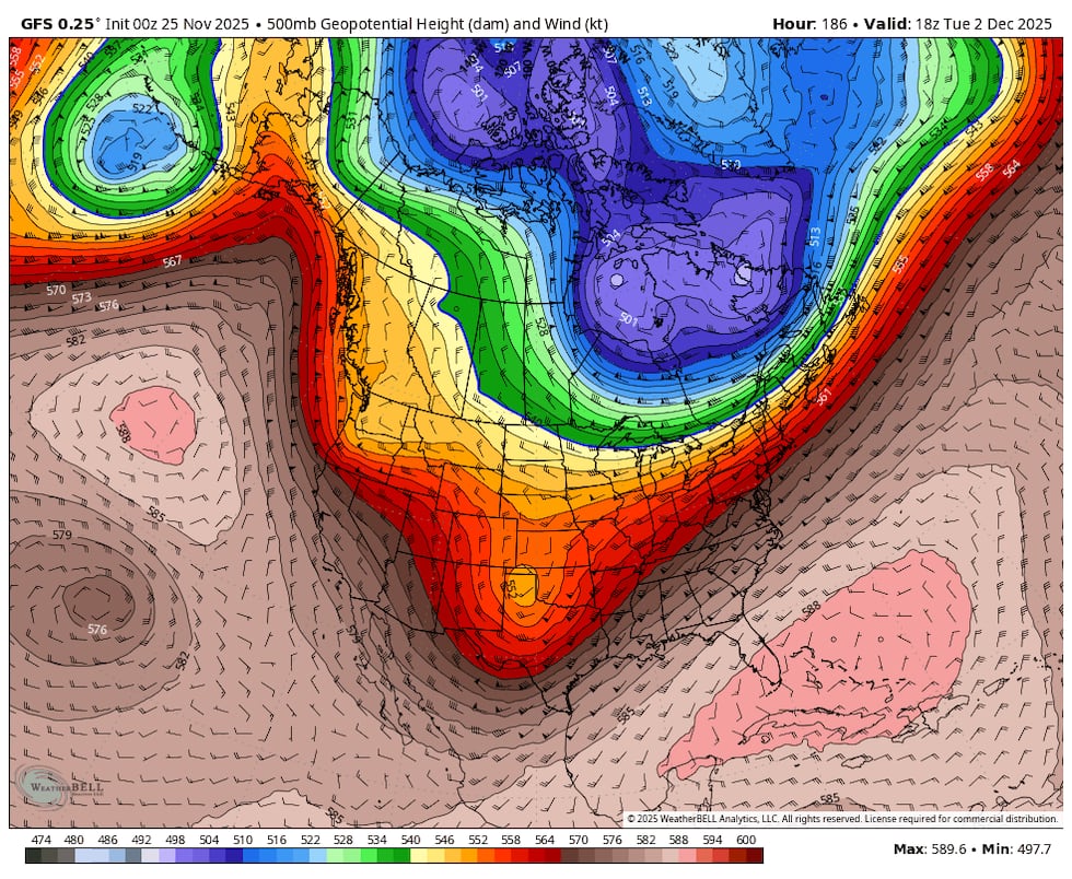
But a change days 10-15. Ridge seems to want to back up a bit, or at least troughs are digging more strongly over us. This could mean a transition to a cool and wet pattern around the first weekend of December. Hopefully so.
(kptv)
This graphic sums things up well for now. In the next 10 days (through the middle of next week), I don’t see any of the “Big Four” weather events that cause trouble west of the Cascades
Long range outlook(kptv)
That wraps it up for this Monday evening. I’ll be off Wednesday through Sunday for the holiday. Back at work on Monday the 1st. This weather blog will be 20 years old on that date! I’ll have to think what wise words I should share…
Of course if something suddenly appears on maps/models for early-mid next week, I’ll get something written up Saturday or Sunday when I’m home.
Weather remains uneventful through at least Friday the 21st
Ski season will not be starting early this year
Slightly cooler next week, then noticeably cooler heading toward Thanksgiving
Don’t forget to download our FOX 12 Weather App Get real-time radar, and regular video updates from our team.
NEW: Check out FOX 12 Weather Extra – a streaming show hosted by our weather team. Tune into our FOX 12 Streaming App weekdays at 7 pm for a detailed forecast. If you’re like me and don’t really know what that is? It’s just another app/tile you can have on your smart TV. For example mine are lined up as “Amazon, Netflix, Hulu, FOX-12″. You get the idea…all our news/weather content is now in that location too. You can see the past few days of our weather show here.
AND…this week Camila and I took a look back at historic snow and ice storms over the last 100 years or so. Plus a few severe cold snaps too. That was during the FOX 12 Weather Podcast. Enjoy!
The 1921 ice storm(kptv)
It’s been a warm November…so far running around 10th warmest in Portland. Doesn’t it seem as if we were cooling down in October, but now that has “stalled”? I checked. That’s kind of the case when you look at the last 30 days at PDX. The red and blue lines go rapidly downhill, yet the actual lows/highs have been holding steady for at least two weeks. In fact one could argue our low temperatures are warmer now than in late October.
The last 30 days in Portland(kptv)
Rainfall has been about average for most of us in southern Washington and northern Oregon.
Rain so far this month(kptv)
It seems like our fall has been a bit “nicer” than I remember; i believe that’s because we’ve had periods of sunshine mixed in with a few rainy days.
WHAT’S AHEAD
Right now, we’re in an incredibly dull weather pattern due to a “split” in the Pacific jet stream. As weather systems approach the North American west coast, a good chunk of the energy is diving south toward California. System #1 will be giving those folks a soaking the next 24 hours.
(kptv)
Even the flatlands of Los Angeles could see 2-4″ rain!
Another deep trough moves toward the coastline Sunday, but you see much of that one is just off the California coastline Monday
(kptv)
Then a 3rd system comes much closer to us on the way south, eventually ending up off the California beaches too. This is Thursday afternoon
(kptv)
So we get some light rain at times, but it’s all weak sauce. No storms, no deep low pressure centers to give us wind, etc… Notice the Canadian forecast model ensemble average only gives us 1-2″ rain in the next 9 days…that’s actually a bit drier than normal for November. Not dry, but just not a big soaking
9 days of precipitation(kptv)
CASCADE SNOW & SKIING
I have been hoping we’d have an early ski season start this year. There was absolutely no data to back that up as a possibility of course. But after the 47″ snow on the ground last year at this time, I was hoping for a repeat. Clearly that’s not going to happen. That said, it’s not unusual to have very little snow on the ground at ski resorts in mid-November. Some years start with a bang, and some ski seasons just limp along from late November through mid-December. You see the big changes from year to year on next Tuesday’s date (18th)
November 18th snow depth at Timberline(kptv)
With weak weather systems, and warmer-than-normal airmasses moving in off the Pacific, there’s no sign of a big “base-building” snowfall. All models look similar to this…the Euro model’s snow forecast through Saturday the 22nd. A bit pathetic
Snow forecast(kptv)
So it’s unlikely ski areas will be operating for the weekend ahead of Thanksgiving. But what about beyond? Possibly a pattern change.
The past 1-2 days, models have been hinting the upper-level pattern may change part way into Thanksgiving week. Ridging developing somewhere to our west, maybe even well north and west toward Alaska. And upper-level troughing may develop somewhere in the western USA. If so, we’d quickly moved into an early-winter weather pattern with much cooler days and lower snow levels. Here’s the morning Euro run height anomaly for the last 5 days of November
A change the last week of November?(kptv)
The new evening Canadian ensemble average looks very similar for the same period.
A change the last week of November?(kptv)
OR, will the ridge develop much closer to us and cold arctic air plunges into the central USA? No one knows this far out. There is lots of talk about a SSW (Sudden Stratospheric Warming) event, a push of cold arctic air, one model run of both the Euro and GFS showing a Thanksgiving weekend snow/ice event.
You get the idea, the pattern MAY change about 10-14 days from now but we don’t yet know how that will play out. So…in the next week you can ignore any silly/scary brightly colored graphics someone shares from FB. I’ll let you know when I actually see something interesting showing up within the 7-10 day period.
THE BASICS:
Commenting on this blog is open to anyone with an interest in or fascination with weather. Here at FOX-12 we're happy to provide you a space to "geek out" with fellow Pacific Northwesterners. But please don't abuse the privilege.
1. POSTING LINKS/VIDEO:
It's okay to insert video or pictures, as long as the link points to something appropriate for the general public. No politics, obscenity, etc...
2. CHOOSE A NAME ONCE:
Choose a name or identification once and stick with it. The very first time you comment it is held for moderation. After it's approved, that EXACT name will be allowed to comment at any time. Note that this applies to your IP address too. So using the same name but on Grandma's computer will require a one-time hold as well. This keeps the spam out.
3. NO PROFANITY:
This is pretty obvious, but avoid being rude or taunting others too.
4. NO RACISM, OR VIOLENT THREATS:
This will get you kicked off quickly. Please report this to me at mark.nelsen@kptv.com if it happens here.


 Posted by Mark Nelsen