The continent of Africa was once largely covered by tropical forests. During the Oligocene and Miocene, the climate slowly cooled, and the forests began to fragment. The forests that covered the plains of East Africa withdrew, leaving fragments of montane forest isolated on mountains where the rainfall remained higher. These isolated forest fragments became refugia in which species unable to survive on the new arid grassy plains became trapped, in pockets of stable moist climate. During the climate fluctuations of the Late Cainozoic these refugia grew and shrank, sometimes permitting species to move between areas and sometimes cutting them off, driving speciation and leading to the appearance of a unique flora and fauna.
Effective conservation efforts for these environments requires the identification of mountain ranges shared geology, evolutionary history, and characteristic species assemblages as distinct ecoregions. For example, the Eastern Arc Ecoregion includes mountain ranges across Kenya and Tanzania, and which has long been seen as a global conservation priority.
Another set of apparently linked mountain ranges is round across southern Malawi and northern Mozambique. In a paper published in the journal Scientific Reports on 12 March 2024, a team of scientists led by Julian Bayliss of the Department of Biological and Medical Sciences at Oxford Brookes University, the African Butterfly Research Institute, and the Rede Para Gestão Comunitária de Recursos Naturais, propose that these mountains be seen as a distinct ecoregion of their own, which they term the South East Africa Montane Archipelago.
Numerous ecological surveys have taken place in southern Malawi over the past century, and have identified the mountains of the country as being of ecological distinctiveness. Mount Mulanje, the second highest free-standing mountain in Southern Africa, at 3002 m, has been identified as being an area of high endemism for both Animals and Plants, and is home to the Mulanje Cedar, Widdringtonia whytei, which is the national tree of Malawi. Mozambique, on the other hand endured a prolonged was for independence from 1964 to 1974, then a long civil conflict between 1977 and 1992. Consequently, the mountain ranges in the northern portion of the country were surveyed between the late nineteenth and mid-twentieth century, then largely ignored by science until the last twenty years. Twenty first century visits to the region began with a series of short visits by ornithologists and herpetologists, which led to a realisation that there was a biological connection between these mountains and those of southern Malawi, followed by a series of targetted expeditions to high mountains and inselbergs in the region, which have discovered many new species unique to the region, and led to an understanding of the importance of these sites.
The name 'South East Africa Montane Archipelago' was first suggested in 2019 at the Annual General Meeting of the Transglobe Expedition Trust of the Royal Geographical Society in London, and formally proposed in 2022 at the 1st Southern African Mountain Conference in Bloemfontein. Bayliss et al. present a formal definition of the region based upon endemic species, geology, topography and climate, and place this in context through comparison with surrounding ecoregions. In doing this they present a synthesis of previous research on the endemic Plants, Mammals, Birds, Reptiles, Amphibians, Crabs, and Butterflies of the region, as well as identifying other groups in need of assessment, and identify the threats to the region's biological distinctiveness and the potential for conservation projects which could protect this.
Bayliss et al. recognise 30 distinct sites within the South East Africa Montane Archipelago, nine of which are in Malawi and 21 within Mozambique. Each has an elevation of at least 800 m above sealevel, with the highest point being Mount Mulanje at 3002 m. All of the sites have high humidity, and at least remnants of humid evergreen forests and upland grasslands, combined with ancient soils, similar climates, and a high rate of endemic species, either unique to a single site or shared between several of them but not found in the lowlands between.
Location and extent of the South East Africa Montane Archipelago showing core sites in red, and an outline boundary of the convex hull of the ecoregion. Bayliss et al. (2024).
The mountains of the South East Africa Montane Archipelago formed between 600 and 125 million years ago, as a result of the intrusion of granitic batholiths into softer metamorphic rock formations, most of which have subsequently eroded away. These batholiths are low in ferromagnesian minerals, with high quartz and feldspar contents, and have a reasonably homogeneous composition, with crystals orientated in a random fashion, all of which makes them resistant to erosion and jointing,
This distinctive weather patterns of the South East Africa Montane Archipelago further contribute to its distinctiveness. The region has a humid climate with high rainfall, fuelled by the southeastern trade winds, which are funnelled up through the Mozambique Channel. Mountains further to the north are in the rain shadow of Madagascar, and have climates driven more by Lake Malawi than the Indian Ocean, while mountains to the south have a drier climate, typically with an arid dry season. Thus the South East Africa Montane Archipelago has a more humid climate that the surrounding regions, with higher rainfall year-round, but particularly in the dry season. This spares the Animals and Plants living their the stresses of seasonal aridity which organisms in the surrounding areas are subject to, enabling evergreen forests to thrive. Within this area, the mountains serve as a trap for orographic rain, so that upland ecosystems receive more moisture than the surrounding lowlands.
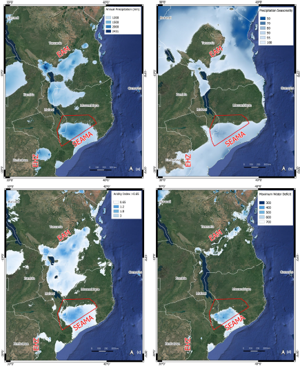
Contemporary macro-climatology of the South East Africa Montane Archipelago. Also labelled is the Eastern Arc Mountains (EAM) ecoregion to the north, and the Eastern Highlands of Zimbabwe to the southwest (EHZ). Annual rainfall (a) is measured in mm. Rainfall seasonality (b) is the coefficient of variation across months. Aridity index (c) is the ratio of annual rainfall to potential evapo-transpiration with values above 0.65, considered humid. Maximum water deficit (d) is a measure of water stress defined across the most arid months of the year, with lower values conducive of potentially dense, evergreen canopy structure. Bayliss et al. (2024).
The region is defined by the furthest extent of mountain ecosystems which fit the criteria for inclusion, plus some other peaks at the fringes of the area which reach the height to qualify (i..e. over 800 m) but have drier climates. It includes the drier, cooler lowlands between the peaks, which are thought to connect the peaks during times of warmer, wetter climate, as well as other peaks within the region which are either too low for montane forest to form, or have already been completely cleared by Human activities.
The whole ecoregion has an area of over 100 000 km² with a core of 3362 km² on the 30 peaks included. This makes it smaller in size than some neighbouring defined ecoregions, such as the Eastern Arc Montane Forests, Southern Rift Montane Forest-grassland Mosaic, or East African Montane Forest ecoregions, but comparable to other mountain ecoregions such as the East African Montane Moorlands and the Knysna-Amatole Montane Forests. It incorporates two previously described ecoregions in southern Malawi, the South Malawi Montane Forest-grassland Mosaic and the Mulanje-Namuli-Ribáuè sub-Centre of Plant Endemism, as well as nine Important Bird Areas and eight Important Plant Areas in Mozambique, and 12 Key Biodiversity Areas across the two countries, and in turn forms part of the Africa-wide Afromontane Archipelago botanical Centre of Endemism.
Currently 192 species and 25 subspecies of Animal and Plant are considered to be strictly endemic to the South East Africa Montane Archipelago, with more endemic Plants than Animals. This is very high for such a limited geographical area, but nevertheless is thought likely to rise significantly as more surveys are carried out. Rates of endemism are particularly high among Reptiles, Amphibians, Mammals, Crabs, and Butterflies. The majority of endemic Animals are forest-dwelling, while the majority of the endemic Plants are grassland and rock-dwelling species. The fauna and flora show some similarities to all the surrounding regions, but are probably most similar to those of Tanzania to the north, suggesting a former belt of humid rainforest stretching along the eastern coast of Africa from the equator to the Mozambique Channel.

Examples of South East Africa Montane Archipelago endemics. (a) Rhinolophus mabuensis, (b) Chamaetylas choloensis, (c) Nothophryne inagoensis, (d) Atheris mabuensis, (e) Epamera malaikae, (f) Rhampholeon maspictus, (g) Nadzikambia baylissi, (h) Maritonautes namuliensis, (i) Euphorbia mlanjeana, (j) Widdringtonia whytei, (k) Encephalartos gratus. Bayliss et al. (2024).
Many of the Plants of the South East Africa Montane Archipelago have their closest relatives within the Southern Afromontane Region, which stretches from southern Tanzania to the Western Cape, rather than East Africa. For Animals, however, the closest relationships are often with East Africa. Most organisms within both groups appear to have diversified from their closest relatives in the Plio-Pleistocene, with the oldest lineages having diversified in the Middle Miocene. This suggests that the forets first began to contract during the Middle Miocene, with subsequent episodes of connection and isolation across the Plio-Pleistocene.
The forests of the South East Africa Montane Archipelago are threatened by slash and burn agriculture and charcoal production, both subsistence activities for local communities. The high fertility of the soil within the forests is highly desirable for the growing of crops such as Maize, Cassava, and Irish Potatoes. The plots upon which these are grown tend to be quite small, but the way in which they are cleared typically affects a much larger area of woodland, both due to the effects of fire, and the subsequent drying of out of areas on the new forest margin (all forests tend to trap moisture in their interiors, with the effect that forest margins are drier environments than forest interiors, and support different species). As more of the forest edge is lost to agriculture the forest interior becomes drier and begins to degrade. Fires also threaten the upland grasslands, in particular the custom of using fires to flush Animals into traps. Thus, any conservation efforts within the South East Africa Montane Archipelago will need to place a strong emphasis on the promotion of more sustainable agricultural practices.
The current protection accorded to the forests of the South East Africa Montane Archipelago differs between the two countries. All of the core sites in Malawi are currently classified as National Forest Reserves, under the administration of the Department of Forestry, though this appears to mean little in terms of actual protection afforded, with forests subjected to both regulated and unregulated timber extraction and charcoal production. Thus, all of the forests on Thyolo Mountain, the type locality for a number of species endemic to the South East Africa Montane Archipelago, has been almost completely cleared, with a remaining area of 2700 m² all on private land. The forests were cleared on Ndirande Mountain in the 1990s, on Soche Mountain in the 2010s, with very little remaining on also most of Chiradzulu Mountain and the Malawi Hills. In Mozambique, only a single site, Mount Ribáuè, is a protected forest reserve, and thisl like other forest reserves in Mozambique, was established to regulate timber harvesting rather than for conservation purposes. There are currently plans for a community conservation projects on Mount Mabu, which the forests are still in reasonably good condition, due to the spiritual status afforded to the area by the local community. A similar spiritual status appears to have protected the also-reasonably-intact forests on Mount Pewé, while other sites, such as Mount Lico, gain some protection from their remote and inaccessible locations.
The degree to which organisms in the core zones of the South East Africa Montane Archipelago are threatened is closely linked to their dependence on montane forests of upland grasslands. The majority of the small Mammal, Bird, Reptile, and Amphibian species are dependent on the presence of forests, and thus most of these are classified as Near Threatened or Threatened (a broad category which includes Vulnerable, Endangered, and Critically Endangered) under the terms of the International Union for the Conservation of Nature's Red List of Threatened Species. The majority of Plants endemic to the region are grassland and rock-dwelling species, which are still under pressure but at less immediate risk than forest-dwelling species, although endemic forest plants are still considered to at high risk levels.
The greatest threats to the endemic organisms of the South East Africa Montane Archipelago are deforestation and the burning of grasslands. Between the years 2000 and 2022, 18% of the primary montane forest in the core areas of the Archipelago was lost, a far higher proportion than in any other African montane ecoregion. Over the same interval, areas such as the Eastern Arc, Cameroonian Highlands, and Mt Cameroon and Bioko montane forests lost less than 5% of their forest cover, while the Albertine Rift and Guinean montane forest lost about 10%. The extent of this loss varies considerably between these sites, with sites such as Chiradzulu, Ndirande, and Thyolo Mountains in Malawi having lost all of their forest cover before 2000, the Malawi Hills having lost 80% of their forest cover since the 1980s, and other sites having suffered high losses over the 2000-2022 interval, such as mounts Nállume 43%, Inago 39%, Ribáuè 35%, Namuli 30%, Socone 18% and Chiperone 14%. Other sites lost less cover over the same period, with mounts Meluli and Mabu having lost about 3% each and Mount Lico having lost less than 2%. Bayliss et al. note that all of the areas with high primary montane forest loss have also lost secondary forests (woodland which has regrown after a major disturbance) and woodland on their lower slopes, leading to an even greater loss of overall forest habitat than the figures suggest.
Bayliss et al. conclude that the South East Africa Montane Archipelago ecoregion can be distinguished form its surrounding areas by a series of biological and abiotic features, including a distinct climate envelope. The area is home to a high number of endemic species, with more likely to be discovered as survey methods imrove. The area is Africa's newest defined ecoregion, but also one of its most threatened, with one of the highest deforestation rates on the continent.
See also...


.png)


.png)

.png)

.png)


.png)
.png)


%20(1)%20(1).png)