Maritime awareness Use Case
Ship detection is an important aspect of maritime awareness, as ships often carry valuable cargo and can pose risks to populations and infrastructure. Receiving timely, reliable, and meaningful information is therefore crucial.
Existing methods already rely on Synthetic Aperture Radar (SAR), optical imagery, and the fusion of SAR or optical data with Automatic Identification System (AIS) signals to identify and track vessels.
In recent years, Artificial Intelligence (AI) and Machine Learning (ML) have become standard tools for detecting vessels in Earth observation (EO) imagery. However, the novelty of the Maritime Awareness use case lies in advancing these capabilities through automatic vessel classification and the integration of neural embeddings. By using both geospatial and AIS data, the use case aims to develop tools that can identify and classify vessels in high‑resolution imagery while also enabling:
- Image compression to improve data transfer latency and facilitate access to relevant sources and collateral data.
- Efficient ship and port monitoring with minimal data labelling, supported by embedding‑based workflows.
The tools developed under this use case will help determine how quickly vessels can be identified and how efficiently this information can be transferred to different users. This workflow spans from wide‑area monitoring to focused analysis of specific target zones, supported by both High Resolution (HR) and Very High Resolution (VHR) imagery.
Data sources used
EO data sources such as Sentinel-1 and -2 and PAZ data, and AIS data are used. The area of interest is the Mediterranean sea, which can be monitored every 12 days by 170 Sentinel-1 products and 250 Sentinel-2 L2A products. These data combined are around a volume of 14TB.
Sentinel-1 Ground Range Detected (GRD) data and Sentinel-2 Level 2A are provided by the project partners through the Copernicus Space Components Data Access (CSCDA) in Analysis Ready Data (ARD) formats. PAZ data are available as Single Look Complex (SLC) data: they require processing steps to create ARD provided by HISDESAT as project partner.
In collaboration with the project partners, compression algorithms were explored to identify the most suitable ones for the planned tasks.
Methodology
The use case for Sentinel-1 vessel detection leverages AI-based object detection techniques in images, specifically the YOLO (You Only Look Once) architecture. This approach is for efficiency and accuracy when identifying vessels in satellite imagery.
The training process relies on a comprehensive dataset constructed with Sentinel-1 backscatter coefficient images and AIS data to provide precise vessel locations at the time of image acquisition. To ensure the accuracy and relevance of the training data, key pre-processing steps are required:
- AIS data pre-processing. AIS data pre‑processing. Vessel locations corresponding to a given Sentinel‑1 acquisition are derived from AIS records. However, because AIS messages and satellite imagery are not captured at exactly the same time, the two datasets are temporally misaligned and must be adjusted to ensure accurate matching.
- Input data preparation. Sentinel-1 images were radiometrically normalised to gamma nought (γ⁰), converted to 8-bit using log-scaled normalisation, and mapped to RGB by adding the VH/VV ratio as a third band. The resulting images were saved in JPG format for compatibility with YOLO.
- Vessel detection algorithm training. The training process for vessel detection utilises the YOLO architecture. The algorithm model is configured with pre-trained weights, enabling it to leverage feature representations learned from broader object detection tasks. This transfer learning approach provides a strong foundation, allowing the model to focus on the unique characteristics of vessels in Sentinel-1 imagery.
- Validation and optimisation. Performances are evaluated using a validation set of unseen Sentinel-1 imagery with annotated vessel locations. Key metrics such as precision, recall, and mean Average Precision (mAP) assess detection accuracy, while hyperparameter tuning enhances generalisation and reduces false positives.
Embeddings
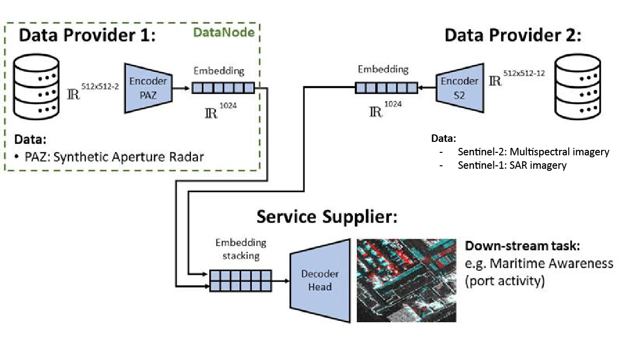
The project relies on a lossy neural compression methodology that generates single timestamp embeddings from the SAR satellite scans of a given geospatial area. This approach is not without challenges: ship geolocations data from satellite acquisitions are difficult to later assemble.
Embed2Scale partners have investigated SAR imagery compression using neural embeddings. Using foundation models to generate embeddings implies among other things a resilience to spatial resolution and image distribution shifts. It also stresses the need for standards for embedding formats, which is another focus of the project.
A benchmark dataset of Sentinel‑1 imagery has been created, consisting of batches of images paired with labels indicating the presence of vessels and their types, as extracted from AIS data. These embeddings will be used to train models that estimate ship counts and positions. However, because ship type detection requires dense, pixel‑level analysis, simple image‑level embeddings remain insufficient.
Expected benefits
The project is expected to enable the automatic detection and classification of vessels using multi-sensor EO data, including Sentinel-1, Sentinel-2, and PAZ data. By leveraging AI-based object detection techniques and neural embedding representations, the developed tools will support efficient wide-area maritime monitoring and targeted analysis of areas of interest.
A key benefit lies in the use of learned embeddings for image compression, which significantly reduces the volume of data that needs to be transmitted while preserving essential information related to vessel presence, location, and characteristics. This approach improves data transfer latency and facilitates faster access to relevant information, enabling timely maritime awareness with reduced communication and storage requirements.
Overall, the project contributes to more efficient identification of vessels, shorter time-to-information, and improved exploitation of high-resolution and very-high-resolution imagery for maritime surveillance applications.
Future work
Sentinel-2 data will also be used to develop vessel detection algorithms based on optical imagery, complementing the Sentinel-1 SAR approach. The detection algorithms will be applied across the entire Mediterranean Sea to monitor vessel presence using both Sentinel-1 and Sentinel-2 embedded information, providing at least two complementary observations and demonstrating the technical advances achieved within the project. In addition, PAZ data will be considered for targeted monitoring of specific areas, such as ports, where high spatial resolution is required.

References
- Lazzarini, M., Belenguer-Plomer, M. A., Albrecht, C. M., Vinge, R. K. A., Marszalek, M., & Albani, S. (2025). Spaceborne SAR compression with AI for data-efficient vessel detection. Presented at the ESA Living Planet Symposium, 23-27 June 2025, Vienna
- Belenguer-Plomer, M. A., Lazzarini, M., Barrilero, O., Saameño, P., & Albani, S. (2025, October). Insights into deep learning-based vessel detection and characterization using SAR and AIS data. In Artificial Intelligence for Security and Defence Applications III (Vol. 13679, pp. 206-210). SPIE.