


Saturday Will Be Mostly Sunny, Scattered Showers, Breezy, 86°F – EXCESSIVE HEAT –
Updated 5/22/26 at 1:23 p.m. AST
Weather updates are posted by Jesse Daley, who has been reporting on weather for the Source since 2022 and holds an Undergraduate Certificate in Weather Forecasting from Pennsylvania State University.
VI SOURCE WEATHER UPDATES
! A VI Source Midweek Weather Video is available here!
SATURDAY’S WEATHER FORECAST: 5/23/26
Happy Saturday!
According to the National Weather Service (NWS), the weather in San Juan, Puerto Rico, Saturday is forecast to be partly cloudy, and scattered showers are possible. The temperature is forecast to rise to around 86°F (30°C), and the heat index is expected to be high. Winds will be gusty, coming from the east, at approximately 22 mph, with gusts reaching 28 mph. The chance of rain on Saturday is 40%.
For Saturday night, conditions are expected to be partly cloudy with scattered showers. The low temperature is forecast to fall to about 78°F (25.5°C). Winds will be gusty, coming from the east, at approximately 22 mph. The chance of rain on Saturday night is 30%.
“At least through the Holiday weekend: morning passing showers are expected across the windward areas of Puerto Rico and the U.S. Virgin Islands, followed by afternoon thunderstorms across central and western Puerto Rico. A moderate risk of life-threatening rip currents will persist across all northern, eastern and southern beaches of the islands. Breezy conditions will result in choppy seas through early next week,” the NWS said.

Yellow = Limited Risk Orange = Elevated Risk Red = Significant Risk

Yellow = Limited Risk Orange = Elevated Risk Red = Significant Risk

Yellow = Limited Risk Orange = Elevated Risk Red = Significant Risk

Yellow = Limited Risk Orange = Elevated Risk Red = Significant Risk
Below: Infrared satellite imagery obtained at 3:40 p.m. AST on Friday indicates a partly cloudy sky across the USVI. Showers are possible.

MARINE WEATHER UPDATE
National Weather Service forecasters report that wave heights on Saturday are expected to build from between 3 and 6 feet.
The NWS provided the following details:
“Moderate to fresh easterly winds will continue across the regional waters through next week due to a strong surface high pressure over the central Atlantic. Choppy seas up to 6 feet will persist across the offshore water and passages, and small craft should exercise caution. Stronger winds and rough seas are expected by Monday, and Small Craft Advisory conditions are possible across the offshore Atlantic waters on Monday and Tuesday. Isolated afternoon thunderstorms are expected to develop near the western coastal waters of Puerto Rico, producing locally higher winds and seas each day,” the NWS explained.

Yellow = Limited Risk Orange = Elevated Risk Red = Significant Risk
The water temperature is approximately 83°F, roughly 28-29°C.
NOAA Ocean Water Temperature Map: 5/22/26:

Risk of Rip Currents:
The NWS explained that the risk of rip currents is projected to be moderate across the USVI on Saturday.
The NWS provided the following details:
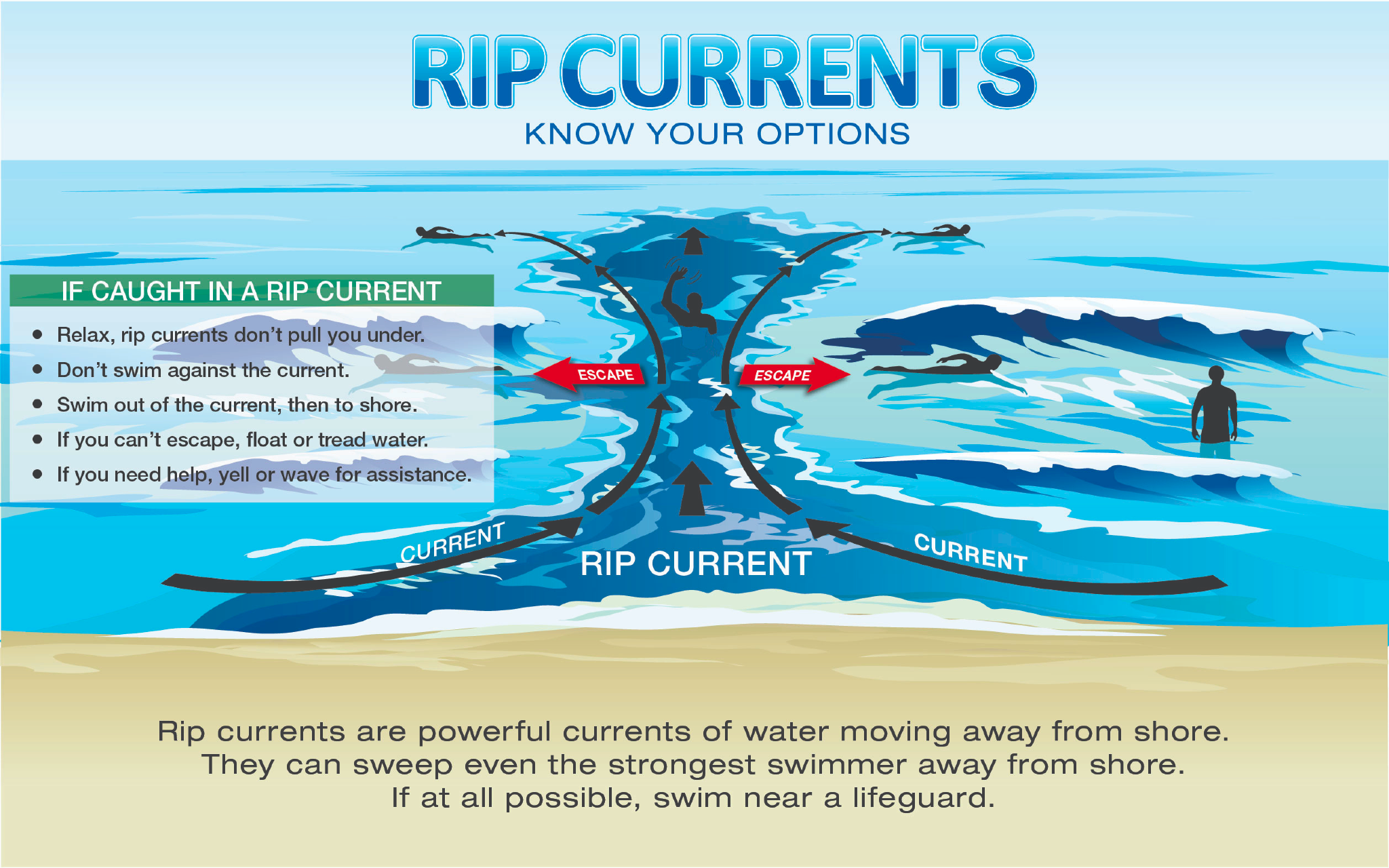
“A moderate risk of rip currents will persist across most local beaches through the next several days due to persistent breezy conditions and wind-driven seas. The highest risk will continue along north, east, and south facing beaches of all the islands. A moderate risk of rip currents means that life-threatening rip currents are possible in the surf zone,” the NWS said.

Clear = Low Rip Current Risk Yellow = Moderate Rip Current Risk Red = High Rip Current Risk
The NWS reminds swimmers that even when there is a lower risk of rip currents, they “can still form near structures like groins, jetties, reefs, and piers.” More information is available here.
Swimmers are encouraged to exercise caution and understand how to escape the pull of a dangerous rip current.

TROPIC WATCH
Tropical Activity:
The 2026 Atlantic hurricane season will begin on June 1, 2026.
National Hurricane Preparedness Week occurred from May 3 – 9. Read more here and watch a video here!
The National Hurricane Center does not expect cyclonic development across the Atlantic basin in the next seven days. However, with the Atlantic hurricane season officially beginning on June 1, it is a good time to prepare. The NHC began issuing daily Tropical Outlooks starting on May 15, 2026.


A VI Source article covering AccuWeather’s 2026 Atlantic hurricane season forecast is available here!
Additionally, a VI Source article covering Colorado State University’s 2026 Atlantic hurricane season forecast is available here!
Super Typhoon Sinlaku recently caused extreme damage to the U.S. territories of Guam and the Northern Mariana Islands. Read more and learn how to help in a VI Source article here.
OBSERVATIONS
Sunrise: 5:45 a.m.
Sunset: 6:49 p.m.
Preparation for extreme weather events in the Caribbean, such as earthquakes and tropical cyclones, is important. Residents and visitors in the USVI are encouraged to stay updated on weather events on the V.I. Source Weather page and sign up for alerts from the National Weather Service and the Virgin Islands Territorial Emergency Management Agency.
Article Series: “Extreme Weather in the Caribbean”
- Part 1: Caribbean Earthquakes and Tsunamis
- Part 2: Caribbean Volcanoes
- Part 3: Rip Currents
- Part 4: Hurricanes
- Part 5: Wildfires
- Part 6: Flash Floods
- Additional articles about earthquakes in the Caribbean are available here and here!
- From Calm to Catastrophic: The Threat of Rapid Hurricane Intensification
- Three Decades After Marilyn, Forecasting and Emergency Preparedness Have Evolved in the USVI
- Please remain prepared for earthquakes and flash flooding across the USVI.
- Three Decades After Marilyn, Forecasting and Emergency Preparedness Have Evolved in the USVI
An on-camera interview between Source weather reporter Jesse Daley and Daryl Jaschen, the director of VITEMA, is available here!