
Weather
StormTRACKER meteorologist Lydia Blume looks at recent rainfalls, drought conditions and what the forecast for the next two weeks looks like in terms of temperature and precipitation.

Despite an initial outlook for more intense storms on Tuesday, Sunday's round of storms proved most impactful to North Dakota producers.

An area in and around Wadena, Minnesota, had a one-two punch of strong winds then golf ball sized hail later that day, leaving behind destruction in central Minnesota.
ADVERTISEMENT

Conditions vary regionally, with some areas showing improvement due to temperature and precipitation levels, while others remain stagnant.

After a severe weather system moved through North Dakota on June 7, a continued threat persists on June 9.
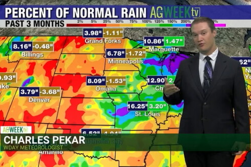
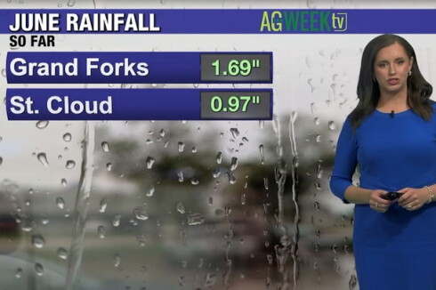
StormTRACKER meteorologist Charles Pekar looks at how much rainfall the region has received this year and explains why there may be some relief from dry conditions.
ADVERTISEMENT
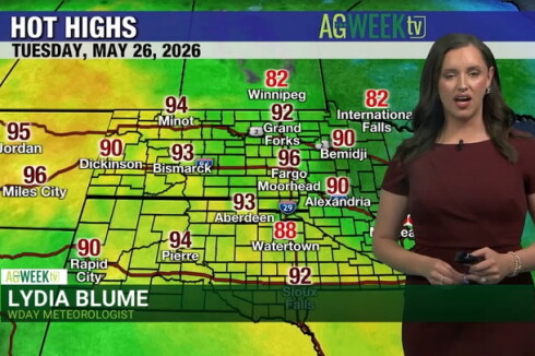
StormTRACKER meteorologist Lydia Blume said far above-normal temperatures are likely to continue into the first half of June, with mostly dry air and chances for thunderstorms.

Topsoil is a precious commodity, with much being lost last week due to high winds. But, there are management practices that can help soil stay in place.
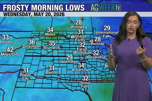
StormTRACKER meteorologist Lydia Blume says the recent cool stretch that produced relatively late frost conditions in places appears poised to move out in favor of above-average temperatures.
ADVERTISEMENT

Jesse Ritka

Lydia Blume

Robert Poynter

Charles Pekar

Robert Daley

Stefan Sundin
ADVERTISEMENT