UPDATE: Category 5 Super Typhoon Ragasa (NandoPH) has just hit a new peak intensity of 180 MPH sustained winds and a minimum central pressure of 905 MBAR.
This intensity is approaching the upper limits of what Earth is capable of producing.
A thread of videos from today’s flight into Hurricane Melissa
In this first one we are entering from the southeast just after sunrise and the bright arc on the far northwest eye wall is the light just beginning to make it over the top from behind us.
This is ominous. You literally cannot see the Philippines from space anymore. The clouds of Typhoon Fung-wong (UwanPH) have almost cloaked the entire archipelago.
BREAKING: Category 5 Hurricane Melissa’s sustained winds are now roaring at 175 MPH, and the air pressure in her searing eye has sunk to 906 MBAR.
The storm is starting to take the northern turn towards Jamaica, and if she intensifies any further, she will begin to approach the
In an era of cheap, overused CGI, Interstellar was a stunning reminder of the realism that can be achieved from physical models. One of the best special-effects-movies of the 21st century. Adding an unbelievable soundtrack score from Hans Zimmer = chills, every time.
At this time in 2024, the Philippines were in the midst of a 10-DAY span in which they were struck by FOUR consecutive Typhoons.
Now this year, the country is reeling from the effects of Kalmaegi (TinoPH) and Fung-wong (UwanPH) both making landfall within the last 5 days.
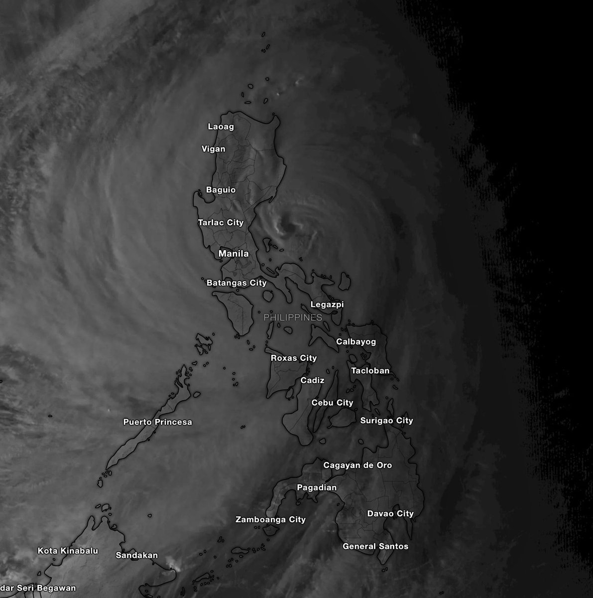
12 years after Haiyan (Yolanda), the storm that displayed these EXTREME satellite images below and devastated Leyte, the Philippines are once again facing a major Typhoon landfall.
Of course, Fung-wong (UwanPH) is thankfully NOWHERE near as strong as Haiyan was, and her damage
Unbelievable. Melissa just surpassed Hurricane Katrina (2005) as the 7TH MOST INTENSE Atlantic Hurricane in recorded history, with her pressure now down to 901 MBAR.
Her torrid eye is reaching unprecedented levels of dryness. -3.94 C at one point. The CDO is shuddering with
BREAKING: Category 5 Hurricane Melissa has achieved a new peak intensity of 180 MPH sustained winds and a core pressure of 896 MBAR.
She is officially the 5TH MOST INTENSE Atlantic Hurricane in history and is nearing the maximum theoretical strength a storm can reach in this
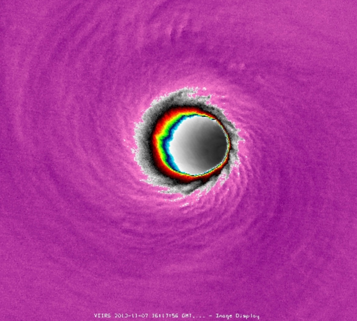
This might be the most insane satellite loop yet of Category 5 Hurricane Melissa.
Her 908 MBAR eye has carved out a near-vertical Stadium Effect.
If you were standing at the center, you’d be in bright sunshine while cliffs of 165+ MPH winds surround you on all sides.
🧵 33 years ago this morning, NWS Miami captured one of the most terrifying radar loops in U.S. History: the eyewall of a Category 5 Hurricane, slicing into a major city while leveling everything in its path.
This is the story of Hurricane Andrew.