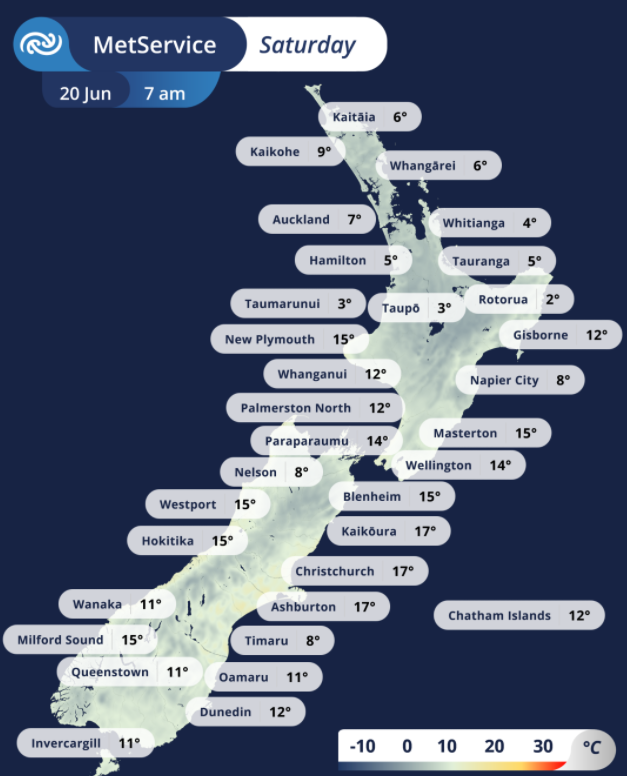
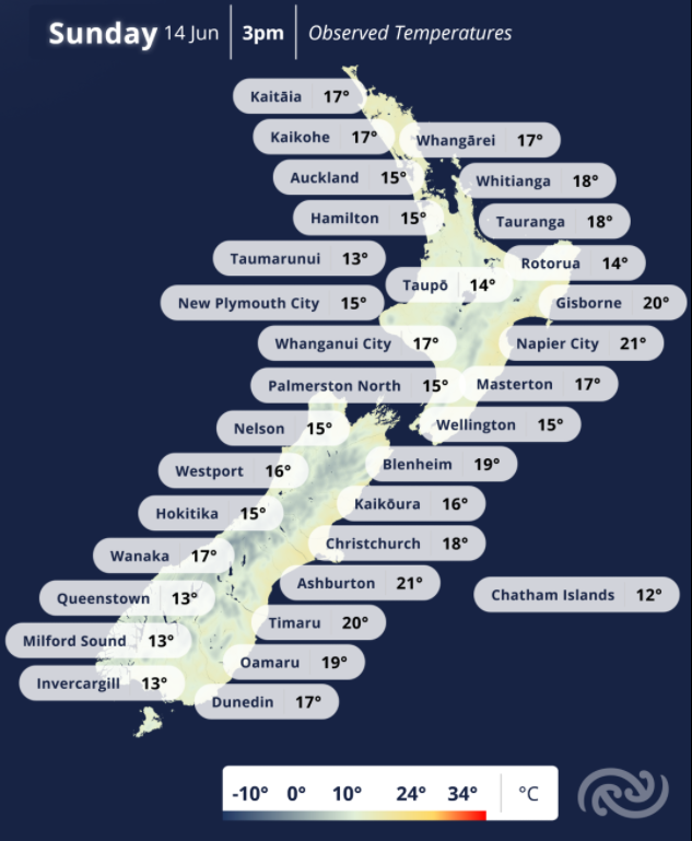
Yesterday Christchurch and Ashburton airports smashed their June temperature records, but today both are over 12Β°C colder than they were 24h ago π₯Ά
This afternoon is forecast to creep up to 11Β°C, but clear skies on the longest night will bring a frosty start tomorrowπ§
MetService NZ
53.8K posts
New Zealand's weather service. Helping Kiwi's be ready, whatever the weather.
- Find out how chilly it's getting at your place at
- As a Wellingtonian and a meteorologist, I'm a little biased, but I reckon the Hurricanes have the most regionally-appropriate name in Super Rugby π¨ Aotea Quay, over the road from the Cake Tin, had several 72km/h gusts during the game, while Hamilton only managed 22km/h πͺ
- Also, Asburton reached 23.8Β°C at midday, beating its previous record of 21.7Β°C in 2024. Up on Banks Peninsula, Cooptown was 25.1Β°C at 1pm β¨οΈ βΌοΈSevere northwesterly gales recorded in Canterbury today. Springfield had gusts of 124 km/h 11am, and Methven gusted 126 km/h at noon.
- Here's forecast for the rugby tonight! All other weather forecasts here β‘οΈmetservice.com/national
- π§π¨Severe Weather Warnings and Watches for Heavy Rain and Severe Northwesterly Gales for southern and central Aotearoa New Zealand have been updated. π§οΈπ βΌοΈMostly valid for today Saturday, but some into Sunday. All the details here metservice.com/warnings/home @NZcivildefence
- Ata mΔrie Aotearoa. A warm night for central and southern Aotearoa New Zealand, with Εtautahi Christchurch and KaikΕura heading to a high of 21β today. π‘οΈπ π§π¨Severe Weather Warnings and Watches for heavy rain and strong winds updated by 10am. Warnings page here
- βοΈLunch is served South IslandβοΈ πIt's a settled weather sandwich π₯ͺ Take a bite while you can, because it won't last for long. And North Island, get hungry because it's coming for you too π For your forecast check here: metservice.com
GIF - πRainband just in time for the Auckland morning commute!π π§οΈA front bringing rain is continuing to march πͺacross the North Island this morning. The band isn't too wide, so a period of rain can be expected followed by some showers, gradually easing with a 'fining up' π€οΈ trend
GIF - #Christchurch, can you relate to our man Shaq here? π‘οΈ Maximum temperature for the day happened at 3am! This was due to a temporary warm nor-west wind, which tried to come back at 5:30am just before the cold southerly air arrived.π΅βπ« Last time Shaq and I checked, temperatures increase during the day and cool off at night, but at times like this when wind is the main driver of the temperature, anything can happen! π Here's the whole graph showing how the cold southerlies have completely cancelled out any
- ποΈπ΄ When the temperature can't be bothered getting up in the morning and decides to chill all day instead π₯Ά π Most places in the South Island have already had their maximum temperature for the day before the sun rose, due to cold air coming in from the south. β¬οΈ The North
- Wondering how warm it is where you are? π Here are our observed temperatures at 3pm. π More info: metservice.com
- Temps are on the rise! π‘οΈπ After a few chilly days, temperatures are forecast to shoot up today with Napier forecast to reach 20C, that's 5C above average! Why? Strengthening northwesterlies are helping to draw warmer air across the country. Find your latest forecast:
- Your Sunday forecast... Strengthening northwesterly winds for central and southern regions with a Strong Wind Watch for Canterbury High Country and the Plains near the foothills where winds may approach severe gale in exposed places. π¨ A band of rain spreading onto the
00:00


