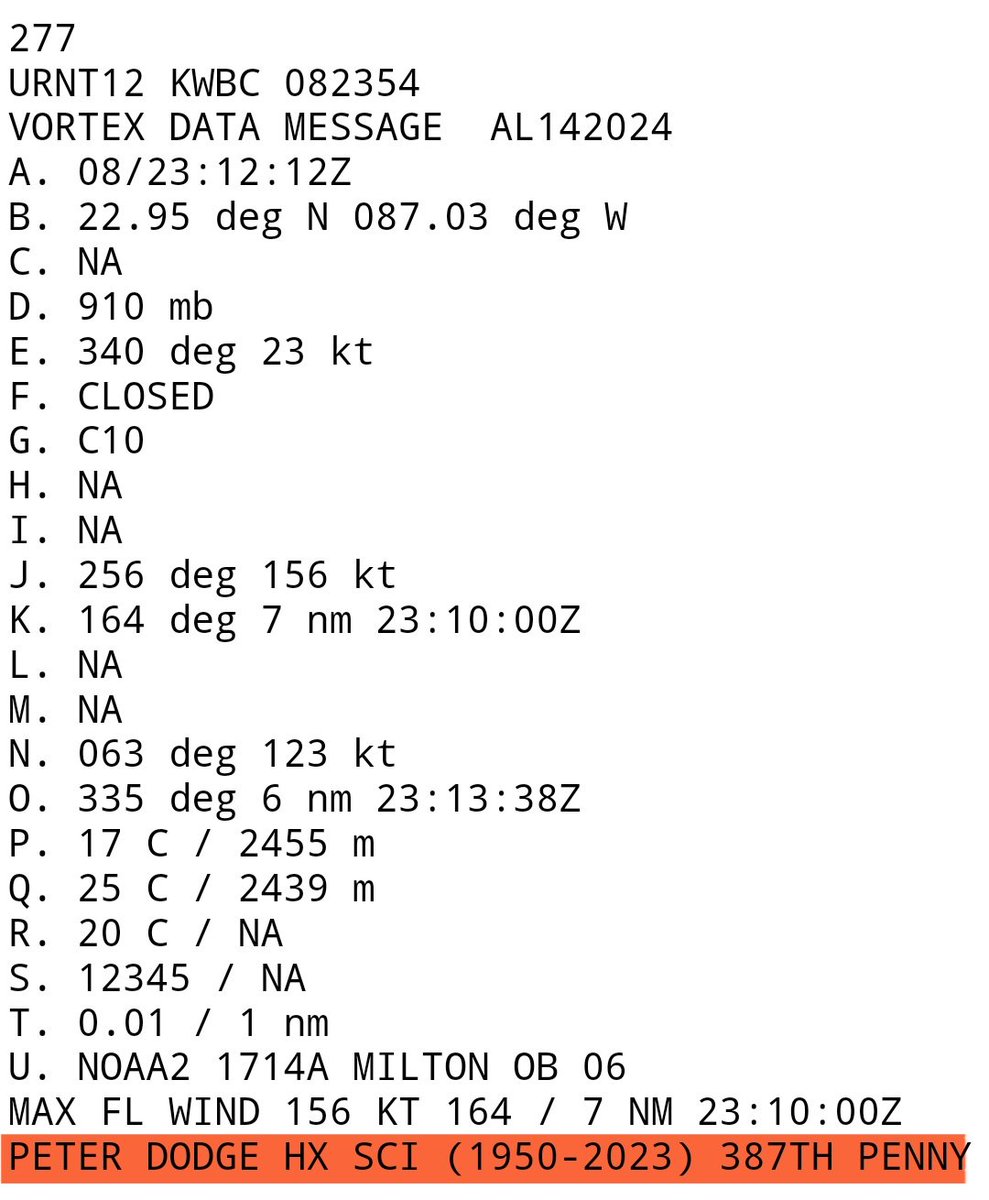
Beautiful tribute from @NOAA_HurrHunter who earlier this evening honored longtime radar scientist and researcher Peter Dodge who passed away in March 2023.
His ashes were dropped in the eye of Category 5 Milton tonight –
PETER DODGE HX SCI (1950-2023) 387TH PENNY
Michael Lowry
23.3K posts
Hurricane Specialist & Storm Surge Expert @WPLGLocal10 Miami. Alum @NWSNHC, @FEMA, @weatherchannel, @UCAR_CPAESS, @DeptofDefense, @FLSERT. Posts my own.
Joined April 2012
- I'm not sure how many truly grasp what just happened tonight with Hurricane #Ian. It went through a full eyewall replacement cycle, hardly blinked, grew by 50% (as measured by its RMW), and delivered the 3rd highest storm surge since 1913 to Key West in the process. Just wow.
GIF - A lot of jaw-dropping satellite loops of Melissa the past day or two, but this one might take top prize. If Dakota hadn't posted this, I might have called AI shenanigans. Surreal.Alrighty, ready to see something really cool? The evolution of Hurricane Melissa's mesovortices at peak strength.
00:00 - A huge blow was dealt to hurricane forecasters this week as a critical tool was abruptly terminated by @DeptofDefense and @NOAA. The immediate discontinuation of data from 3 weather satellites will severely impact hurricane forecasts this season and beyond michaelrlowry.substack.com/p/critical-hur…
- Category 5 Hurricane #Irma closing in on the Leeward Islands with sustained 185 mph winds. Catastrophic damage expected along its path.
GIF - We knew this day could come but here we are. The 2026 proposed @NOAA budget shutters all world-class federally funded meteorological, oceanographic, and climate labs in America. Included is @HRD_AOML_NOAA, a fixture for over 50 years in Miami. Hundreds of top scientists tossed.
- It's disappointing major weather media groups that exist off NOAA/NWS data have been deafeningly silent about federal staffing hits and proposed cuts to NOAA. No letters of support. No news reporting on their detrimental effects to forecasting. Just glaring editorial omission. 🧵
- The Atlantic Ocean has a lot to say right now. And none of it is particularly good. My take on the deep Atlantic heat – which blows May 2005 out of the water – how it could impact hurricane season, and how it's affecting us today via @CC_Yale
GIF- We can squabble over what's behind the rapid Atlantic warming, but it's truly extraordinary to see waters in the Main Development Region of the tropics as warm in June as they typically are the first week of *September*. An undeniably big player this hurricane season.
GIF - Hurricane #Lee is in elite company tonight. Fewer than 1% of all tropical cyclone "fixes" ever attain Category 5 strength. Lee is the farthest southeast we've ever observed a Category 5 hurricane in the Atlantic since records began 172 years ago. Lorenzo (2019) the farthest east.
- Only four named storms this century have been as large over the Gulf of Mexico (measured by the extent of tropical storm winds) as Helene is forecast to become by tomorrow: Irma (2017) Ike (2008) Ivan (2004) Isidore (2002)
- I know others have tweeted something similar, but to see a catastophic Category 5 hurricane closing in our 3rd most populous state is wildly unnerving. #Dorian is already a disaster for so many tonight. Please, please heed the warnings of local officials in the hours ahead.
GIF - The Gulf of Mexico this week is the hottest it's been at any point in any year on record by a wide margin. Weekly averaged Gulf sea surface temperatures have never broken 87°F but this week topped 88°F, an astonishing 1.4°C (2.6°F) above the 1991-2020 average.
GIF


