Log inSign up
NWS Amarillo
43.2K posts
Image
user avatar
NWS Amarillo
@NWSAmarillo
Official X account for the National Weather Service Amarillo. Details: weather.gov/nws_x
Amarillo, Texas
weather.gov/ama
Joined June 2012
148
Following
37.8K
Followers
  • user avatar
    NWS Amarillo
    @NWSAmarillo
    4h
    There will be recurring chances for storms most days next week, peaking around mid week. Some details will need to come into better focus as we get closer, but we'll monitor strong/severe storm potential along with where rain chances are locally higher each day. #phwx #txwx #okwx
    A regional weather pattern graphic from NWS Amarillo highlighting 40 to 60 percent storm chances each day Monday through Thursday next week. It shows high pressure west of the Panhandles with small low pressure systems approaching from northwest of the Panhandles.
    577
  • user avatar
    NWS Amarillo
    @NWSAmarillo
    7h
    As morning showers and storms clear out, temperatures will warm back into the 80s today. Additional showers could form across the east, but the better area to watch for storm chances will be the western Panhandles for activity moving out of New Mexico. #phwx #txwx #okwx
    A two panel graphic from NWS Amarillo featuring forecast high temperatures mostly in the 80s today, with 10 to 20 percent chances of showers and storms across the eastern and western Panhandles. Peak timing is 1 PM to 12 AM.
    548
  • user avatar
    NWS Amarillo
    @NWSAmarillo
    9h
    Thunderstorms are moving slowly north this morning. The main hazard with these storms is heavy to very heavy rain which may result in localized flash flooding. While the chance is low, cannot rule out some small hail. #txwx #phwx
    4:10 AM: Thunderstorms are moving slowly north this morning. The main hazard with these storms is heavy to very heavy rain which may result in localized flash flooding. While the chance is low, cannot rule out some small hail.
    448
  • user avatar
    NWS Amarillo
    @NWSAmarillo
    10h
    A special weather statement has been issued for Wellington TX, Clarendon TX and Howardwick TX until 4:00 AM CDT
    This graphic displays a special weather statement plotted on a map. The statement is in effect until 4:00 AM CDT.  The statement includes Wellington TX, Clarendon TX and  Howardwick TX.  A STRONG THUNDERSTORM WILL IMPACT COLLINGSWORTH AND DONLEY COUNTIES THROUGH 400 AM CDT. The threats associated with this storm are wind gusts up to 30 MPH and half inch sized hail. Seek shelter in a sturdy structure until the storm passes.
    304
  • user avatar
    NWS Amarillo
    @NWSAmarillo
    10h
    3 AM: Thunderstorms are quickly developing across the southeastern Texas Panhandle. These thunderstorms will move very slow and will produce heavy to very heavy rain. Localized flash flooding will be possible this morning across this area. #txwx #phwx
    3 AM: Thunderstorms are quickly developing across the southeastern Texas Panhandle. These thunderstorms will move very slow and will produce heavy to very heavy rain. Localized flash flooding will be possible this morning across this area.
    315
  • user avatar
    NWS Amarillo
    @NWSAmarillo
    11h
    Thunderstorms are staying mostly to our south for now, but we may see additional thunderstorms develop further north over the next few hours.
    2:10 AM: Thunderstorms are staying mostly to our south for now, but we may see additional thunderstorms develop further north over the next few hours.
    283
  • user avatar
    NWS Amarillo
    @NWSAmarillo
    13h
    We're seeing some rain showers develop across the SE TX Panhandle which may develop into storms. A few strong to severe storms will be possible tonight, mostly across the SE. Storms will produce heavy rain which may lead to localized flash flooding. #txwx #okwx #phwx
    We're seeing some rain showers develop across the southeastern Texas Panhandle which may develop into thunderstorms through the next couple of hours. A few strong to severe thunderstorms will be possible tonight, mostly across  the southeast. Thunderstorms will produce heavy rain which may lead to localized flooding or flash flooding.
    384
  • user avatar
    NWS Amarillo
    @NWSAmarillo
    22h
    Storm chances are expected to ramp up later tonight across the E Texas Panhandle and persist well into early Fri morning. These storms can strengthen into strong to severe t-storms during this time frame with large hail & flooding the primary threat. #phwx #txwx #okwx
    The graphic calls for a return of showers and thunderstorms today, with the highest potential in the Southeastern Texas Panhandle. Developing storms have the potential to be strong or severe, with activity expected between 1 AM and 7 AM Friday. The most likely hazards are heavy rainfall, and frequent lightning, but large hail remains possible if a storm can become severe.
    An NWS Amarillo graphic highlighting the southeast Texas Panhandle for a slight risk of flash flooding tonight due to excessive rainfall. Timing peaks from 7 PM tonight to 7 AM Friday.
    A map highlights a level 1 marginal risk of severe storms today covering eastern Texas panhandle cities like Wheeler and Wellington. Potential hazards include ping pong ball size hail and 60 mph wind gusts. Timing is 7 PM to 7 AM Friday.
    768
  • user avatar
    NWS Amarillo
    @NWSAmarillo
    Jun 18
    Any storms that develop today will have the ability to produce heavy downpours, which could pose a localized flash flooding risk. This is especially true of the SE TX Panhandle which has 10-40% probabilities to exceed 1" of rainfall by tomorrow morning. #phwx #txwx #okwx
    An NWS Amarillo graphic highlighting the southeast Texas Panhandle for a slight risk of flash flooding tonight due to excessive rainfall. Timing peaks from 7 PM tonight to 7 AM Friday.
    556
  • user avatar
    NWS Amarillo
    @NWSAmarillo
    Jun 18
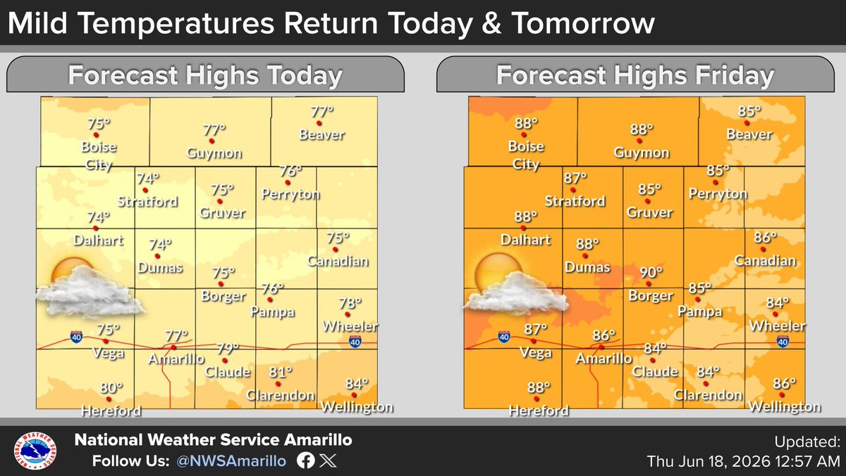
    After a toasty Wednesday, much welcomed cooler temperatures in the 70s and cloudy skies are expected today, with 80s tomorrow across the Panhandles. #phwx #txwx #okwx
    A two panel graphic from NWS Amarillo featuring forecast high temperatures mostly in the 70s today, increasing into the 80s on Friday.
    556
  • user avatar
    NWS Amarillo
    @NWSAmarillo
    Jun 18
    While some spotty light sprinkles/showers can't be ruled out today, storm chances ramp up later this evening-overnight across the eastern TX Panhandle. Activity could become strong/severe with large hail & gusty winds the primary threats, along with locally heavy rainfall. #phwx
    The graphic calls for a return of showers and thunderstorms today, with the highest potential in the Southeastern Texas Panhandle. Developing storms have the potential to be strong or severe, with activity expected between 7 PM Thursday and 7 AM Friday. The most likely hazards are heavy rainfall, and frequent lightning, but strong winds and large hail remain possible if a storm can become severe.
    A map highlights a level 1 marginal risk of severe storms today covering eastern Texas panhandle cities like Wheeler, Wellington, and Canadian. Potential hazards include ping pong ball size hail and 60 mph wind gusts. Timing is 5 PM to 7 AM Friday.
    475
  • user avatar
    NWS Amarillo
    @NWSAmarillo
    Jun 17
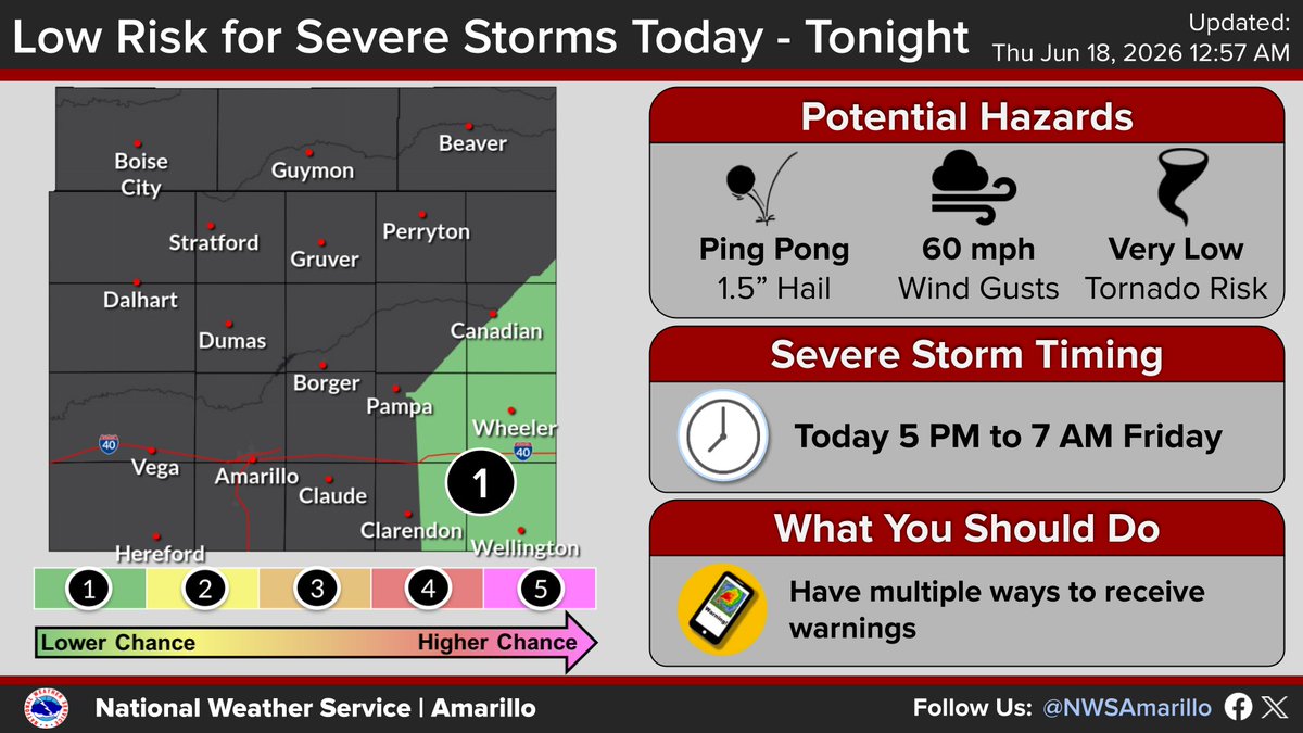
    Showers and thunderstorms are expected to return tomorrow, primarily in the Southeastern Texas Panhandle. While heavy rain is most likely, strong to severe storms are possible. Stay updated and ensure you have multiple ways to receive warnings. #phwx #okwx #txwx
    The graphic calls for a return of showers and thunderstorms, with the highest potential in the Southeastern Texas Panhandle. Developing storms have the potential to be strong or severe, with activity expected between 7 PM and 7 AM Thursday. The most likely hazards are heavy rainfall, and frequent lightning, but strong winds and large hail remain possible if a storm can become severe.
    1.1K
    user avatar
    NWS Amarillo
    @NWSAmarillo
    Jun 17
    Updated graphic:
    The graphic calls for a return of showers and thunderstorms, with the highest potential in the Southeastern Texas Panhandle. Developing storms have the potential to be strong or severe, with activity expected between 7 PM and 7 AM Thursday. The most likely hazards are heavy rainfall, and frequent lightning, but strong winds and large hail remain possible if a storm can become severe.
    559
  • user avatar
    NWS Amarillo
    @NWSAmarillo
    Jun 17
    Tropical Storm Andrew is expected to push inland across the gulf coast later this week, which could result in impacts to travel. If you are planning to head that way make sure to check with the @NHC_Atlantic as well as local forecast offices to get the latest weather information.
    Tropical Storm Andrew is expected to push inland across the gulf coast later this week, which could result in impacts to travel. If you are planning to head that way make sure to check with the National Hurricane Center as well as local forecast offices to get the latest weather information.
    869
    user avatar
    NWS Amarillo
    @NWSAmarillo
    Jun 17
    Apologies, Tropical Storm Arthur.
    525

New to X?

Sign up now to get your own personalized timeline!

Create account

By signing up, you agree to the Terms of Service and Privacy Policy, including Cookie Use.

Terms of Service|Privacy Policy|Cookie Policy|Accessibility|Ads info|© 2026 X Corp.
Don't miss what's happening
People on X are the first to know.
Log inSign up
Advertisement
Advertisement