Very warm and dry conditions combined with west to northwest winds gusting up to 45 mph will result in critical fire weather conditions Wednesday afternoon and early evening for the mountains and mountain valleys. #cowx
Near-normal temperatures are expected today before a warming trend peaks Wednesday. Hot, dry, and breezy weather will lead to elevated fire weather conditions Tuesday, with critical fire weather conditions expected Wednesday. #cowx
Much cooler temperatures and cloudy skies are on tap for today. Best chances for precipitation will be south of I-70 this afternoon and evening where showers and a few weak storms will be possible. #COwx
A cold front will bring gusty northeasterly winds and cooler temperatures to the lower elevations today. Isolated to scattered showers/weak storms will be possible this afternoon, mainly for the southern foothills and Palmer Divide. #COwx
Today will be a cooler, but sunny day with near-average temperatures expected. Winds will be breezy at times across the area. Warmer temperatures will return tomorrow with highs for the plains near 90 degrees! #COwx
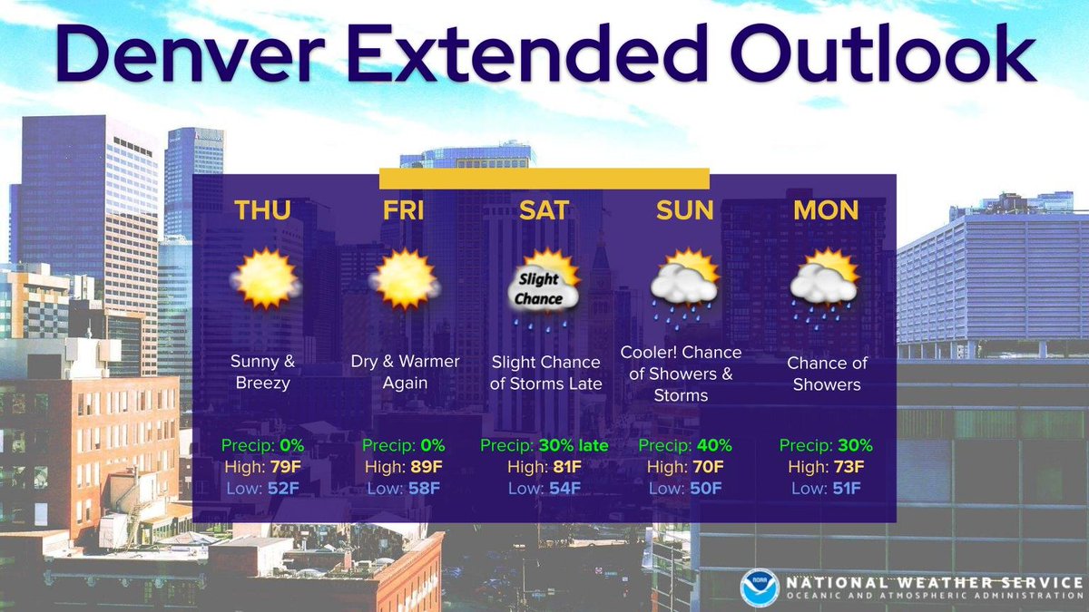
📆Five Day Planner:
Dry through most of Saturday, then a chance of showers and a few storms by the latter half of the weekend into Monday.
Cooler today, very warm Friday, and then much cooler with springlike temps by Sunday. #COwx
Today will be a warm and breezy day. In addition, critical fire weather conditions are likely for the plains. A strong cold front will move through overnight bringing more gusty winds! #COwx
📆Five Day Planner:
Dry through most of Saturday, then increasing shower and storm chances by Saturday night and Sunday.
Very warm today and then again Friday to Saturday. Much cooler by Sunday. #COwx
Weather conditions will once again be favorable for rapid fire spread, particularly where recent precipitation and spring green-up has been limited. Exercise fire safety precautions! #COwx