Log inSign up
NWS Cheyenne
33.2K posts
Image
user avatar
NWS Cheyenne
@NWSCheyenne
Official Twitter account for the National Weather Service Cheyenne, Wyoming. Details: weather.gov/twitter
Cheyenne, Wyoming
weather.gov/cys/
Joined June 2012
152
Following
19.8K
Followers
  • user avatar
    NWS Cheyenne
    @NWSCheyenne
    4h
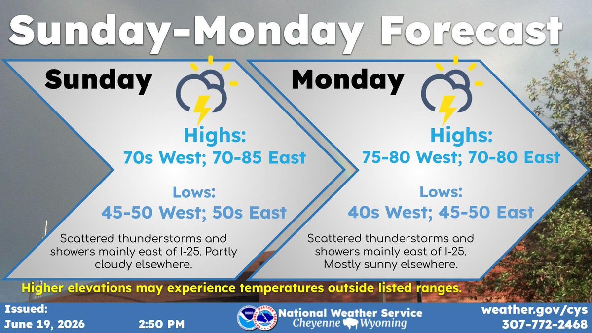
    Weather Sunday and Monday are expected to be much the same with afternoon thunderstorm and showers east of I-25. Outside these afternoon storms, partly cloudy to mostly sunny skies with seasonable temperatures persist. Dry and breezy conditions for our western areas. #wywx #newx
    A simple text graphic showing the anticipated weather conditions Sunday and Monday. Afternoon storms and seasonable temperatures .
    229
  • user avatar
    NWS Cheyenne
    @NWSCheyenne
    5h
    Scattered severe thunderstorms likely Saturday afternoon and through part of the night. The main concern is with the initial daytime storms, though several rounds are possible. Hazards include very large hail, severe winds, a few tornadoes, and isolated flooding. #wywx #newx
    Map of southeast Wyoming and western Nebraska showing where severe weather is possible Saturday. The Sidney and Kimball areas have the greatest risk of tornadoes. In addition anticipated hazards with timing information is presented.
    307
  • user avatar
    NWS Cheyenne
    @NWSCheyenne
    Jun 18
    We are watching the potential for severe weather this Saturday, June 20th. The environment appear supportive of severe hail and winds, especially for the NE Panhandle counties. As the event nears we will have higher confidence in timing and intensity. #wywx #newx
    Map of southeast Wyoming and western Nebraska showing where severe weather is possible Saturday. In addition a matrix of anticipated risk categories is on the right.
    373
  • user avatar
    NWS Cheyenne
    @NWSCheyenne
    Jun 18
    We have a pleasant day to look forward to on Friday. Low rain chances with sunny and seasonable weather through most of the day. Overnight winds slightly increase along with cloud coverage for our western areas. #newx #wywx
    Two graphics make up this story. On the left is a map showing the area Afternoon highs Friday, mostly being in the high 70s to mid 80s. On the right are the nighttime low temperatures dropping to the 50s.
    301
  • user avatar
    NWS Cheyenne
    @NWSCheyenne
    Jun 18
    This weekend is shaping up to be on the stormy side and cooler. Widespread thunderstorms in the PM could bring rounds of heavy rain and severe weather. Overnight activity moves east with some lingering rain. Storms form again Sun PM making way to a cloudy night. #newx #wywx
    Weekend forecast graphic with a plot of the max chance of precipitation across the region during Saturday on the left. Most places near I-25 have a 40 to 60 percent chance of rain, east of there 70 to 85 percent. On the right side is a summary of weather and max/min temperatures for the PM and AM.
    335
  • user avatar
    NWS Cheyenne
    @NWSCheyenne
    Jun 18
    We are watching the potential for severe weather this Saturday, June 20th. We are still ironing out the details as to what we can expect, but the environment east of the Laramie Range looks favorable for the development of strong to severe storms. #WYwx #NEwx
    Map of southeast Wyoming and western Nebraska showing where severe weather is possible Saturday.
    821
  • user avatar
    NWS Cheyenne
    @NWSCheyenne
    Jun 16
    Look for windy conditions and critical fire danger on Wednesday. Dry conditions continue with lighter winds Thurs and Fri. Expect a cooling trend Saturday into early next week with chances for showers and storms returning to the area. #wywx #newx
    (Left) Weekly weather highlights
(Middle) Forecast daily high temperature for Cheyenne (top), Laramie (middle) and Scottsbluff (bottom) Wednesday-Tuesday
(Right) Forecast probability of precipitation for Cheyenne (top), Laramie (middle) and Scottsbluff (bottom) Wednesday-Tuesday
    375
  • user avatar
    NWS Cheyenne
    @NWSCheyenne
    Jun 16
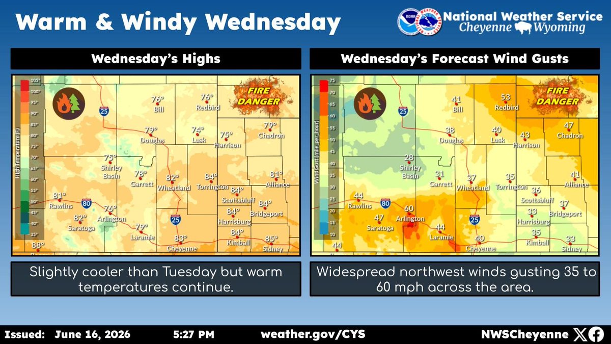
    Warm, dry, and windy weather will continue on Wednesday, keeping fire danger very high. While temperatures will be cooler than Tuesday, winds will be a bit stronger across the area. Red Flag Warnings remain in effect for the High Plains until 10PM Wednesday. #wywx #newx
    (Left) forecast high temperature for Wednesday map 
(Right) forecast maximum wind gusts for Wednesday map
    332
  • user avatar
    NWS Cheyenne
    @NWSCheyenne
    Jun 16
    June 16th, 4 AM - The High Wind Watches for portions of southeast Wyoming have been upgraded to High Wind Warnings. Gusts up to 65mph are expected, with gusts 40-50mph outside of the wind prone regions. Use caution if traveling with lightweight or high profile vehicles. #WYwx
    Graphic with an image of the High Wind Warning on the left. On the right is information about the Warning.
    331
  • user avatar
    NWS Cheyenne
    @NWSCheyenne
    Jun 16
    June 16th, 3:30 AM - Fire Weather Watches have been upgraded to Red Flag Warnings from noon today through 10 PM Wednesday. Low humidity coupled with wind gusts 40-60mph will create dangerous conditions for rapid fire spread. Avoid open flames and/or creating sparks. #WYwx #NEwx
    Graphic with an image of the Red Flag Warning on the left. On the right is information about the Red Flag Warning.
    297
  • user avatar
    NWS Cheyenne
    @NWSCheyenne
    Jun 15
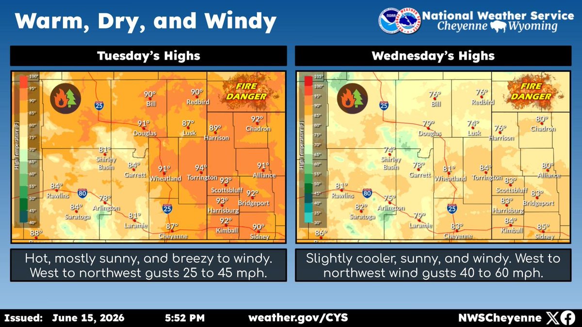
    Warm, dry, and windy weather will continue through at least Wednesday. Expect hot temperatures Tuesday with west to northwest winds gusting 25 to 45 mph. Wednesday will be slightly cooler, but with stronger winds gusting 40 to 60 mph. #wywx #newx
    (Left) Forecast highs for Tuesday, (right) Forecast highs for Wednesday
    396
  • user avatar
    NWS Cheyenne
    @NWSCheyenne
    Jun 15
    June 15th, 3 AM - A High Wind Watch has been issued for the typical wind prone regions of southeast Wyoming from 6 PM Tuesday through 3 PM Wednesday afternoon. Wind gusts up to 65 mph are possible. Use caution if traveling with lightweight or high profile vehicles. #WYwx #NEwx
    Graphic with an image of the High Wind Watch for the wind prone regions of southeast Wyoming on the left. On the right is information about the High Wind Watch.
    343
  • user avatar
    NWS Cheyenne
    @NWSCheyenne
    Jun 14
    Fire danger will be the theme of the week ahead with warm temperatures, low humidity, and gusty winds. Expect widespread strong winds Wed, which may impact travel. Precip chances will finally return by the weekend, but amounts and details remain uncertain. #wywx #newx
    Graph of forecast high temperatures Monday through Sunday for Cheyenne (top), Laramie (middle) and Scottsbluff (bottom), with expected weather type at the bottom
    469

New to X?

Sign up now to get your own personalized timeline!

Create account

By signing up, you agree to the Terms of Service and Privacy Policy, including Cookie Use.

Terms·Privacy·Cookies·Accessibility·Ads Info·© 2026 X Corp.
Don't miss what's happening
People on X are the first to know.
Log inSign up
Advertisement
Advertisement