Log inSign up
NWS GSP
53.4K posts
Image
user avatar
NWS GSP
@NWSGSP
Official X Account for National Weather Service Greenville-Spartanburg, SC. Details: weather.gov/nws_x.
Greer, SC
weather.gov/gsp/
Joined June 2012
461
Following
36.5K
Followers
  • user avatar
    NWS GSP
    @NWSGSP
    2h
    During a flood, water levels and the rate at which the water is flowing can quickly change. Get to higher ground. Do not drive or walk into water. It only takes 6 inches of water to knock you off your feet. Link: weather.gov/safety/flood #scwx #ncwx #gawx
    3 Steps for Flash Floods: 1. Get to higher ground (get out of the areas subject to flooding). 2. Do not drive into water (do NOT drive or walk into flooded areas. It only takes 6 inches of water to knock you off your feet). 3. Stay informed: Monitor local radar, television, weather radio, internet or social media for updates. During a flood, water levels and the rate at which the water is flowing can quickly change. Remain aware and monitor local radio and television. WHEN FLOODED TURN AROUND DON'T DROWN
    585
  • user avatar
    NWS GSP
    @NWSGSP
    4h
    ON THIS DATE, 15 YEARS AGO: Storms moved out of east TN, crossed the mountains of NC, & then moved over the foothills/Piedmont producing widespread severe weather across the region. 2 people were struck by lightning on the Chattooga River in Oconee County (SC). #scwx #ncwx #gawx
    Image
    871
  • user avatar
    NWS GSP
    @NWSGSP
    5h
    The remnants of Arthur will track across the forecast area late this afternoon into late tonight. A few strong to severe storms are possible with this system, starting late this afternoon. #ncwx #scwx #gawx
    Graphic showing a marginal risk in place across the western Carolinas and northeast Georgia from late this afternoon through late tonight (5 PM to 2 AM). Damaging winds will be the main hazard with any severe storms that develop. However, an isolated brief tornado cannot be entirely ruled out.
    1.1K
  • user avatar
    NWS GSP
    @NWSGSP
    20h
    A stalled front across #gawx #scwx #ncwx will interact with the remnants of TS Arthur to produce locally heavy rain, mainly Thu night. Most of this rain could fall within 1 to 3 hours, and if so could lead to rapid rises on small streams and isolated areas of flash flooding.
    A map shows the ranges of rainfall totals potentially occurring between Wednesday evening and early Saturday morning (June 17-20, 2026) across parts of the NWS Greenville-Spartanburg forecast area.
    1.2K
  • user avatar
    NWS GSP
    @NWSGSP
    Jun 17
    PTC 1 became organized enough this morning to be designated Tropical Storm Arthur. This doesn't change the expected impacts for NC/SC/GA. We're closely evaluating the potential for severe storms or flash flooding in our area, mainly SE of I-85. #ncwx #scwx #gawx
    Forecast cone graphic from the National Hurricane Center, annotated with the following supplied by NWS Greenville-Spartanburg, for western NC/SC and northeast GA:
PTC 1 near the Texas coast strengthened enough Wednesday to be named Tropical Storm Arthur. Arthur will weaken it moves inland tonight.  Its remnants still are expected to travel along a stalled front toward the Carolina coast Thursday night into early Friday, which could pose a risk of severe storms, especially along and SE of I-85. 3" to 5" rainfall is possible along and south of the stalled front, but confidence remains low how far north that rainfall may extend into our area.  Such amounts would be associated with a flash flood risk. Wind gusts of 25-35 mph remain likely Thursday, though not attributable to Arthur.
    938
  • user avatar
    NWS GSP
    @NWSGSP
    Jun 17
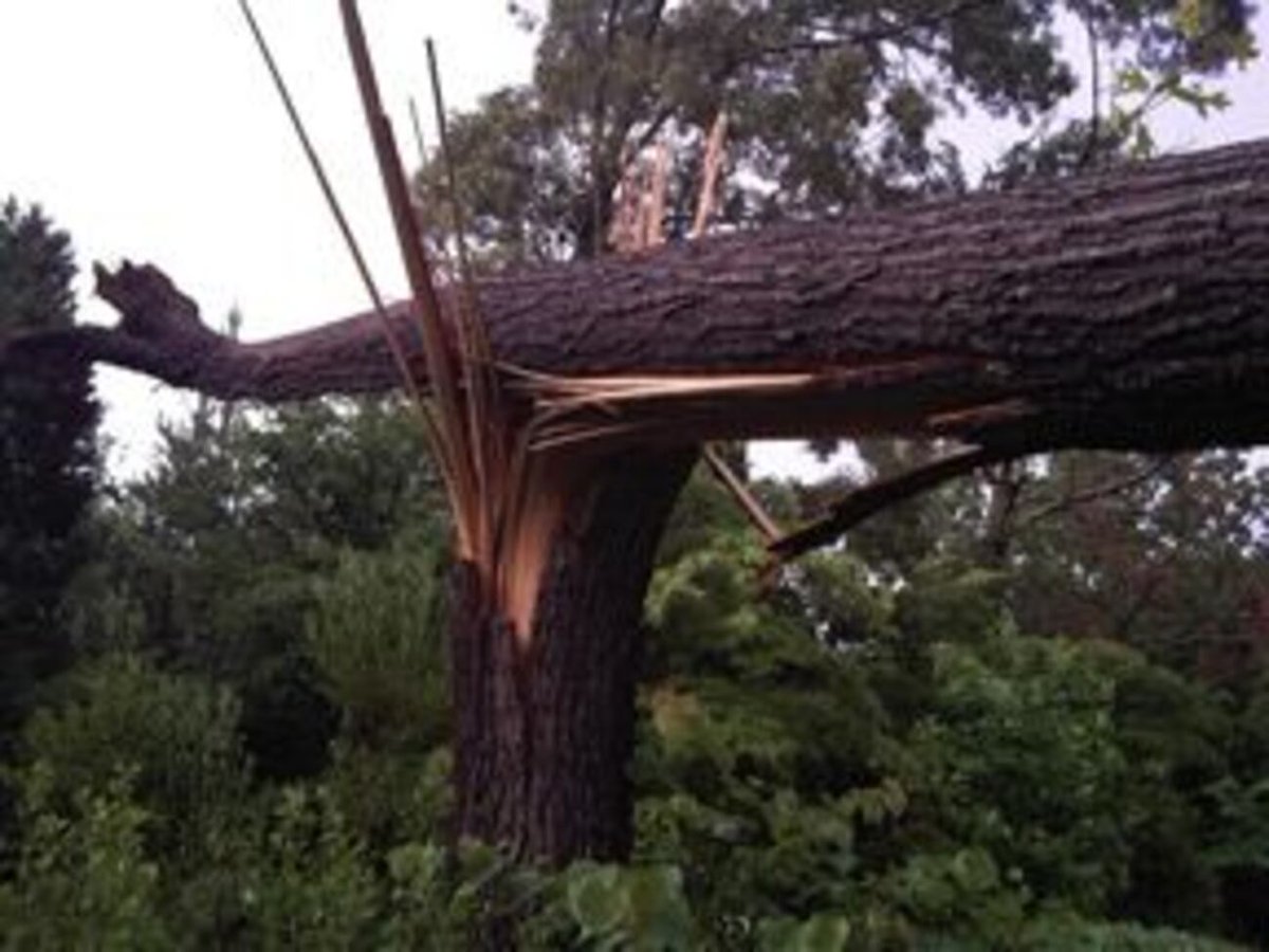
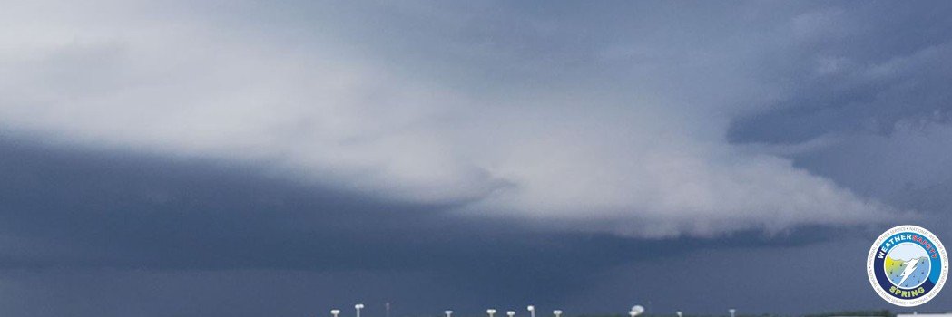
    ON THIS DATE, 4 YEARS AGO: Scattered thunderstorms developed over western NC. Several storms produced brief damaging wind gusts. Gusty winds associated with a weakening line of showers and storms blew down a tree onto a vehicle at the Biltmore Easte, killing an occupant. #ncwx
    Image
    Image
    1.2K
  • user avatar
    NWS GSP
    @NWSGSP
    Jun 17
    Temperatures rebound to around normal under mostly sunny skies today. Humidity will remain low, keeping heat index values close to the ambient temperatures. #ncwx #scwx #gawx
    Temperatures Rebound Today. Temperatures rebound to around normal under mostly sunny skies today. Humidity will remain low, keeping heat index values close to the ambient temperatures. Map shows forecast high temperatures today, mainly in the 80s in the mountain valleys and Piedmont.
    1.3K
  • user avatar
    NWS GSP
    @NWSGSP
    Jun 16
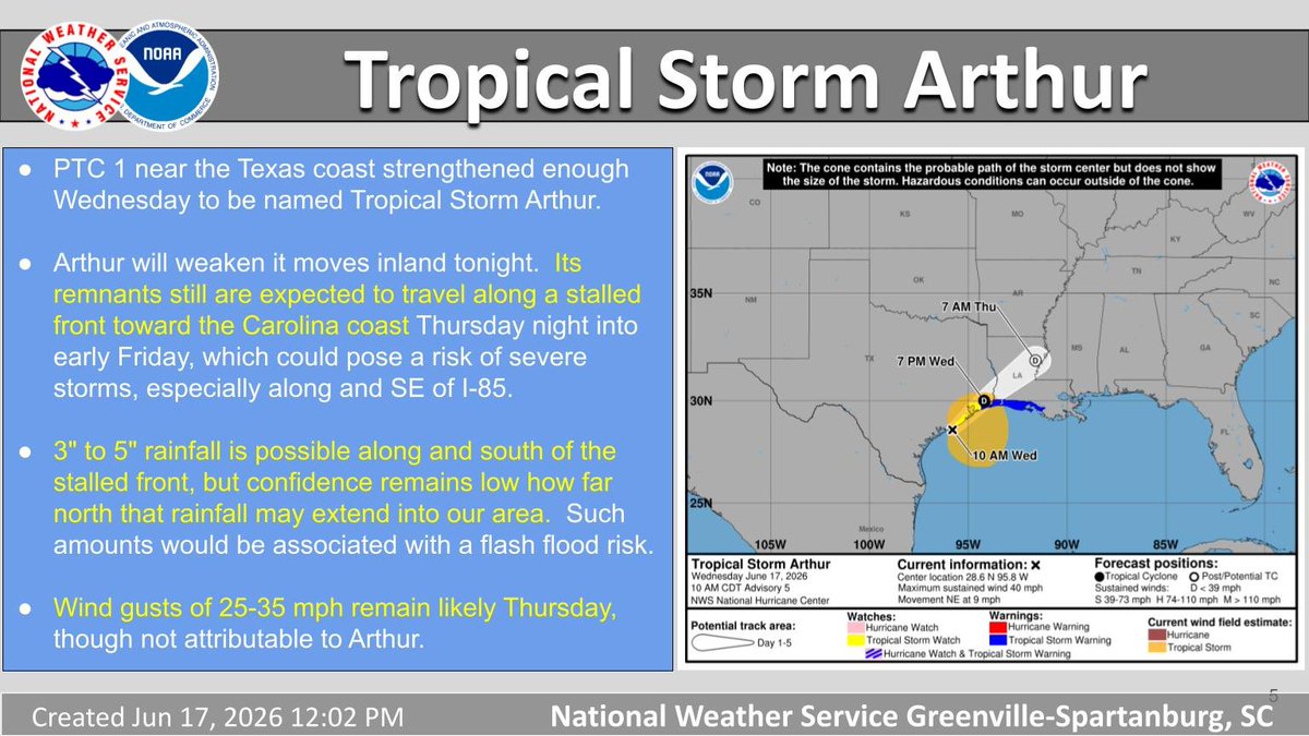
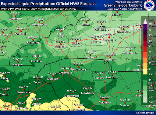
    Quiet weather continues tomorrow, but an active pattern is set to return Thursday and Friday. 💨Winds will be gusty Thursday with 25-35 mph gusts common and winds up to 45 mph across the higher mountain elevations. 🌧️Rain chances also return, especially along and south of I-85
    Image
    Image
    2K
  • user avatar
    NWS GSP
    @NWSGSP
    Jun 16
    Low pressure near the western Gulf Coast is now designated Potential Tropical Cyclone 1. PTC 1 will merge into a stalled front across the SE US; tropical cyclone impacts unlikely for NC/SC/GA but heavy rain and severe storms possible Thu-Fri; winds gusty Thu. #ncwx #scwx #gawx
    KEY MESSAGES about PTC 1 from the National Hurricane Center:  1. Potentially life-threatening flash and urban flooding is possible 
across the Texas coast eastward into central Mississippi through Thursday. Prolonged rainfall may extend the flood threat into the weekend. Widespread small stream and minor river flooding is expected along the Texas coast into southwest Louisiana, with isolated areas of significant river flooding possible across the Texas Coast and Louisiana.  2. Potential Tropical Cyclone One is forecast to become a tropical storm as it moves along or just off the northwestern Gulf coast through Wednesday.  Tropical Storm Watches have been issued from Sargent, Texas, to Morgan City, Louisiana.  3. Minor to moderate coastal flooding is expected along portions of the Upper Texas and Louisiana coastlines.
    Maps depict the areas of focus for potentially active weather Thursday and Friday, June 18-19, 2026, in the western Carolinas and northeast Georgia.  A caption reads, "Expect gusty winds Thursday of 25-35 mph due to a stalled front across GA/SC.  PTC 1 will interact with this front, enhancing heavy rain potential and posing a flash flooding threat for parts of our area.  Thunderstorms also may pose a risk of damaging winds."
    1.2K
  • user avatar
    NWS GSP
    @NWSGSP
    Jun 16
    ON THIS DATE, 17 YEARS AGO: Severe storms produced widespread damage across Upstate SC, including a 92-mph wind gust near Owings in Laurens County (SC) that killed 1 person. 2 tornadoes developed in Cleveland County (NC), near the Beam Mill & Stony Point communities. #scwx #ncwx
    Image
    Image
    1.2K
  • user avatar
    NWS GSP
    @NWSGSP
    Jun 16
    Relatively dry weather expected through Wednesday, but a front will bring rain chances Thursday through Friday. There could be some heavy rain in the western parts of the forecast area. #ncwx #scwx #gawx
    Rain Chances Return Thursday through Friday. Map on the right is the Five Day Precipitation Forecast starting at 8 am today and ending 8 pm on Saturday. Areas in green range from 0.5 inch to 1.5 inches. Yellow to orange in the western part of the forecast area is for values from 1.5 to 3 inches. Dark orange is 3 to 4 inches. A cold front will approach from the northwest on Thursday, and could bring a chance for heavy rain across mainly the western parts of the forecast area.
Showers continue into Friday, but dry weather should return for the weekend.
There could be a low end threat for isolated flash flooding, with a small threat of isolated severe storms Thursday.
    1.9K
  • user avatar
    NWS GSP
    @NWSGSP
    Jun 15
    You’re ready for the beach, but are you Weather-Ready? Be prepared for, and know how to react to, weather and water hazards such as rip currents & dangerous waves, excessive heat, and lightning. Link: weather.gov #scwx #ncwx #gawx
    Weather-Ready for the Beach? 1. Rip currents and dangerous waves: Swim at beaches with lifeguards, and never swim alone. If caught in a rip, don't panic, call for help, and swim along the shore. Supervise young or inexperienced swimmers. 2. Excessive Heat: Remain hydrated. Wear light, loose-fitting clothing and use sunscreen. Relax in the shade and cool off in the water. 3. Lightning: If you hear thunder or see lightning, go immediately to an enclosed building or hard-topped vehicle.
    1.6K
  • user avatar
    NWS GSP
    @NWSGSP
    Jun 15
    Much cooler with lower humidity returning Tuesday. #ncwx #scwx #gawx
    Graphic showing high temperatures on Tuesday (6/16/26) across the western Carolinas and northeast Georgia. Cooler and less humid Tuesday with below normal highs returning. Highs Tuesday will end up around 4-8 degrees below normal for this time of year. Afternoon temperatures will only reach into the upper 70s to lower 80s east of the mountains and the lower 70s to upper 70s across the mountains. Most locations will remain dry on Tuesday but a few showers are possible across northeast Georgia and the southern South Carolina Upstate.
    1.2K

New to X?

Sign up now to get your own personalized timeline!

Create account

By signing up, you agree to the Terms of Service and Privacy Policy, including Cookie Use.

Terms of Service|Privacy Policy|Cookie Policy|Accessibility|Ads info|© 2026 X Corp.
Don't miss what's happening
People on X are the first to know.
Log inSign up
Advertisement
Advertisement