Log inSign up
NWS Grand Forks
30.2K posts
Image
user avatar
NWS Grand Forks
@NWSGrandForks
Official Twitter account for the National Weather Service Grand Forks. Details: weather.gov/nws_x
Grand Forks, ND
weather.gov/grandforks/
Joined June 2012
189
Following
16.2K
Followers
  • user avatar
    NWS Grand Forks
    @NWSGrandForks
    2h
    Isolated strong to severe thunderstorms are possible today across parts of the area. The strongest storms could bring hazards including 1 inch hail and wind gusts to 60 mph. Elsewhere, lightning, small hail, and wind gusts to 50 mph are the primary risks. #NDwx #MNwx
    Isolated severe thunderstorms are possible across west central Minnesota today. Hazards could include 1 inch hail and wind gusts to 60 mph.
    434
  • user avatar
    NWS Grand Forks
    @NWSGrandForks
    Jun 17
    Scattered showers and thunderstorms are expected to continue to move across eastern ND and northwest MN through this afternoon, with lightning the main threat. Another quick moving system may bring additional shower and thunderstorm chances late Thu night into Fri. #NDwx #MNwx
    Forecast graphic from NWS Grand Forks showing a rainbow over a country road. Text details today's highs of 65 to 71 with scattered storms. The next three days show lows in the mid-40s to low-50s, with highs warming from the upper-60s on Thursday to the mid-to-upper 70s by Friday and Saturday under clearing conditions.
    761
  • user avatar
    NWS Grand Forks
    @NWSGrandForks
    Jun 16
    Scattered showers and isolated thunderstorms redevelop this afternoon then increase in coverage tonight, continuing through Wednesday. The main threat with thunderstorm activity will be lightning. #NDwx #MNwx
    Forecast graphic from National Weather Service Grand Forks for eastern ND and northwest and west central MN. Graphic details today's highs at 70 to 77, Wednesday highs 62 to 69 with rain showers and thunderstorms, Thursday highs 64 to 69, and Friday highs 68 to 76 with afternoon storms. Background image shows showers looming over fields.
    769
  • user avatar
    NWS Grand Forks
    @NWSGrandForks
    Jun 15
    Isolated strong to severe thunderstorms are possible today across parts of southeast North Dakota, the southern Red River Valley, and west central Minnesota. Primary hazards will be hail up to 1 inch and wind gusts to 60 mph this afternoon and early evening. #NDwx #MNwx
    Graphic shows the severe thunderstorm outlook for this afternoon and evening. Isolated strong to severe thunderstorms could produce 1 inch hail and wind gusts to 60 mph.
    968
  • user avatar
    NWS Grand Forks
    @NWSGrandForks
    Jun 15
    Areas of showers and scattered thunderstorms are expected today across eastern ND and northwest/west central MN, and a few strong thunderstorms may develop this afternoon. Wind gusts to 50 mph and small hail would be the main threats. #NDwx #MNwx
    Forecast graphic by the National Weather Service in Grand Forks, ND covering eastern ND and northwest MN. Additional temperature and wind details in the forecast graphic. Today: NW winds 10–25 mph, Highs 69–79°F. Tuesday: Lows 42–49°F, Highs 69–76°F. Wednesday: Lows 48–54°F, Highs 64–69°F. Thursday: Lows 43–50°F, Highs 62–68°F. Right side of the graphic shows a photo of a double rainbow over trees.
    804
  • user avatar
    NWS Grand Forks
    @NWSGrandForks
    Jun 14
    Partly cloudy skies and breezy conditions are expected, with mild temperatures. There are better chances for showers and scattered thunderstorms Monday and Wednesday, and a few strong thunderstorms with small hail may develop Monday afternoon. #NDwx #MNwx
    National Weather Service graphic for eastern ND and northwest and west central MN showing a scenic landscape under a partly cloudy sky.  Forecast details: Today features northwest winds 10 to 20 mph, gusts to 30 mph, and highs 67–74°F. The next 3 days display low/high temperature ranges: Monday (47–52°F / 70–80°F), a dry and partly cloudy Tuesday (43–50°F / 66–75°F), and Wednesday (46–53°F / 64–72°F).
    834
  • user avatar
    NWS Grand Forks
    @NWSGrandForks
    Jun 13
    A cool (for mid June) day is expected today, with windy and cloudy conditions, with scattered sprinkles. Warmest temperatures will tend to be where there are more breaks in cloud cover (generally in far southeast ND and west central MN). #NDwx #MNwx
    Weather forecast infographic for eastern ND and northwest and west central MN, detailing a windy, cool day today with high temperatures in the upper 50s to mid-60s. Includes a 3-day outlook showing breezy conditions Sunday, rain and thunderstorms likely Monday, and partly sunny skies Tuesday, with temperatures gradually warming into the 70s. A right-side photo illustrates a dark, overcast sky with a few rain showers over a field.
    756
  • user avatar
    NWS Grand Forks
    @NWSGrandForks
    Jun 12
    Cooler than normal temperatures for mid June as we head into the weekend. Gusty west to northwest to continue, though not as noticeable in the treed part of our region. Isolated showers or maybe a t-storm today with a slight chance for showers Saturday. #NDwx #MNwx
    Four-period forecast graphic from NWS Grand Forks. Today: Highs 65-78 with west winds 15-30 mph. Saturday (Coolest and windiest period): Lows 45-53, highs 58-68, northwest winds gusting up to 35 mph. Sunday: Warmer and mostly sunny, lows 42-48, highs 67-73. Monday: Lows 45-50, highs 68-74 with a late-day chance of showers and thunderstorms.
    809
  • user avatar
    NWS Grand Forks
    @NWSGrandForks
    Jun 11
    A cold front moves through today giving showers and scattered afternoon thunderstorms. Then much cooler airmass behind it lasting into the weekend with gusty west to northwest winds. #NDwx #MNwx
    Four-panel forecast graphic from NWS Grand Forks. Today: Becoming cloudy, chance for showers and t-storms (highest north), west wind 15-25 mph, highs 67-73. Tonight: Chance evening showers then partly cloudy, west wind 10-20 mph, lows 48-54. Friday: Partly cloudy and windy, west wind 15-30 mph, highs 68 north to 80 south. Saturday: Partly to mostly cloudy and windy, northwest wind 20-35 mph, lows 45-54, highs 60-68.
    761
  • user avatar
    NWS Grand Forks
    @NWSGrandForks
    Jun 10
    Severe Thunderstorm Warning including Beltrami County, MN until 4:45 PM CDT
    This graphic displays a severe thunderstorm warning plotted on a map. The warning is in effect until 4:45 PM CDT. The warning includes Beltrami County, MN.  This warning is for Northeastern Beltrami County in north central Minnesota. The threats associated with this warning are wind gusts up to 60 MPH and quarter sized hail. There are 6 people in the warning along with 0 schools and 0 hospitals.
    638
  • user avatar
    NWS Grand Forks
    @NWSGrandForks
    Jun 10
    Severe Thunderstorm Warning including Wadena MN, Park Rapids MN and Menahga MN until 5:15 PM CDT
    This graphic displays a severe thunderstorm warning plotted on a map. The warning is in effect until 5:15 PM CDT. The warning includes Wadena MN, Park Rapids MN and Menahga MN.  This warning is for Southern Hubbard County in north central Minnesota, Wadena County in central Minnesota, Northeastern Otter Tail County in west central Minnesota and Southeastern Becker County in northwestern Minnesota. The threats associated with this warning are wind gusts up to 60 MPH and quarter sized hail. There are 31,452 people in the warning along with 18 schools and 5 hospitals.
    741
  • user avatar
    NWS Grand Forks
    @NWSGrandForks
    Jun 10
    Severe Thunderstorm Warning including Red Lake MN, Redby MN and Wilton MN until 5:15 PM CDT
    This graphic displays a severe thunderstorm warning plotted on a map. The warning is in effect until 5:15 PM CDT. The warning includes Red Lake MN, Redby MN and Wilton MN.  This warning is for Northwestern Hubbard County in north central Minnesota, Southeastern Beltrami County in north central Minnesota and Southeastern Clearwater County in northwestern Minnesota. The threats associated with this warning are wind gusts up to 60 MPH and quarter sized hail. There are 29,541 people in the warning along with 22 schools and 3 hospitals.
    526
  • user avatar
    NWS Grand Forks
    @NWSGrandForks
    Jun 10
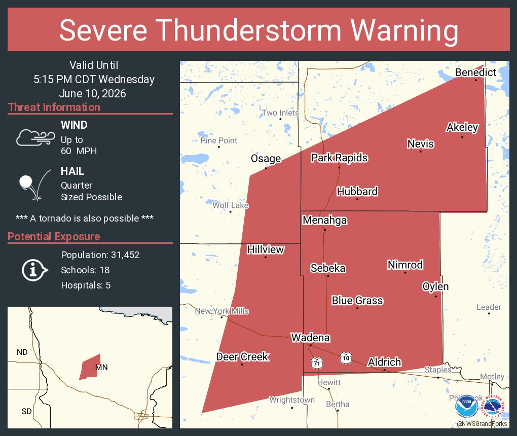
    Thunderstorms are developing in MN. Some of these storms may become strong to severe. Make sure you remain weather aware this afternoon, and have a way to recieve any potential warnings for your area. Storms will decrease in intensity during the evening hours. #MNwx
    NWS Grand Forks map highlighting storm timelines for northwest and west-central Minnesota. A red zone indicates ongoing storms, some severe, continuing for the next 3 hours. A yellow zone to the south indicates storms developing within 1 to 3 hours. Graphic includes a reminder to plan shelter locations now.
    955

New to X?

Sign up now to get your own personalized timeline!

Create account

By signing up, you agree to the Terms of Service and Privacy Policy, including Cookie Use.

Terms of Service|Privacy Policy|Cookie Policy|Accessibility|Ads info|© 2026 X Corp.
Don't miss what's happening
People on X are the first to know.
Log inSign up
Advertisement
Advertisement