Log inSign up
NWS Key West
29.2K posts
Image
user avatar
NWS Key West
@NWSKeyWest
Extending the reach of NWS information to the Florida Keys. Visit goo.gl/C9g6i for details & feedback. Cover photo credit to Merideth Rue 6/16/17.
Key West, Florida
weather.gov/key
Joined May 2012
524
Following
55.8K
Followers
  • user avatar
    NWS Key West
    @NWSKeyWest
    4h
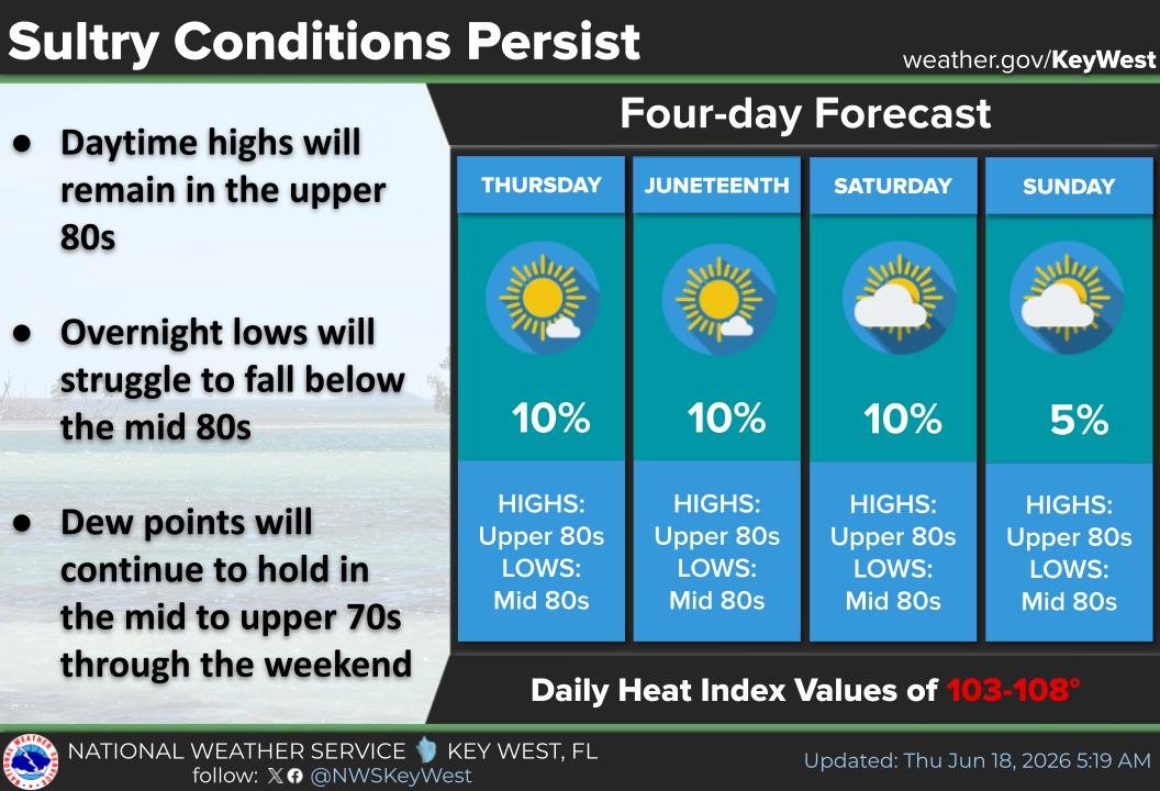
    Other than an isolated stray shower this morning, it's expected to be mainly dry again for today. Highs will top out near 90° with dew points in the upper 70s. This will once again result in heat index values of 103-108°, especially for the Upper Keys. #FloridaKeys #FLwx
    Forecast for the Florida Keys for Friday, June 19th. Text reads; Rain chances: 10% or less today. Expected highs: Upper 80s/near 90°. Dew points: Upper 70s. Resulting in Heat Index Values of 103-108°. Additional text in the accompanying post. On the right is an image of the Southernmost Buoy.
    410
  • user avatar
    NWS Key West
    @NWSKeyWest
    8h
    Perhaps not surprisingly, the lows of 84°F at Key West & Marathon held yesterday, setting a new daily warm low record at Key West & tying the record for Marathon. Previous records: #KeyWest 83°, most recently set in 2025 & #MarathonFL's 84° was most recently tied in 2013. #flwx
    This graphic shows a warm sunset view with the silhouette of a flamingo in the water. It states that a new daily warm low temperature record of 84 degrees was set at Key West on June 18th.
    This graphic shows a warm sunset view with the silhouette of a flamingo in the water. It states that a the daily warm low temperature record of 84 degrees was tied at Marathon on June 18th.
    318
  • user avatar
    NWS Key West
    @NWSKeyWest
    16h
    Warm days have been transitioning into even warmer nights (when comparing both to normal). Key West & Marathon's lows of 84°F are 4° & 5° above the long-term average, respectively. If these lows hold, #KeyWest will set a new daily warm low record & #MarathonFL will tie. #flwx
    This graphic shows a sunset water view on the left and tonight's forecast on the right (Tonight: Lows in the mid 80s, SE winds 5-10 mph, Slight chance (10%) of showers/thunderstorms.) It also includes the record information mentioned in the accompanying post.
    484
  • user avatar
    NWS Key West
    @NWSKeyWest
    Jun 18
    Despite the sultry conditions, we're expecting mainly dry weather over the next few days. Rain chances will be 10% or less through the upcoming weekend. Meanwhile, heat index values will range from 103-108°, especially in the Upper Keys. #FLwx #FloridaKeys #BeatTheHeat
    Graphic is a four-day forecast for the Florida Keys. Daytime temperatures will reach the upper 80s while overnight lows will fall only into the mid 80s. Meanwhile, dew points of mid to upper 70s will result in heat indices of 103-108°, especially in the Upper Keys
    397
  • user avatar
    NWS Key West
    @NWSKeyWest
    Jun 18
    Low temperatures of 84°F at Key West & Marathon yesterday tied the daily warm low temperature records at both sites. This record was previously set at Key West in 2023 (most recently) & at Marathon in 2013 (also most recently.) #flwx #FloridaKeys #FLKeys #KeyWest #MarathonFL
    This graphic shows a warm sunset view with the silhouette of a flamingo in the water. It states that the daily warm low temperature record of 84 degrees was tied at both Key West and Marathon for June 17th.
    378
  • user avatar
    NWS Key West
    @NWSKeyWest
    Jun 17
    Just a slight chance of showers/storms again tonight, with lows in the lower 80s & SE-S winds ~10 mph, decreasing to 5-10 mph. Dew points ~80°F to keep heat index values elevated for remainder of the week, especially for the Upper #FLKeys where values could exceed 105°F. #flwx
    This graphic shows a warm evening view of an aircraft approaching Key West, accompanied by tonight's forecast and the aforementioned heat safety tips.
    382
  • user avatar
    NWS Key West
    @NWSKeyWest
    Jun 17
    We have our first named storm of the Atlantic Hurricane Season! Anyone with interests near & along the Gulf Coast of Texas and Louisiana should monitor Tropical Storm Arthur forecasts, watches, warnings, and updates at hurricanes.gov ! #NHC #Arthur #TropicalStormArthur
    Graphic shows location of Tropical Storm Arthur, along with the Tropical Storm watches and warnings in effect along the Texas and Louisiana Gulf Coast.
    518
  • user avatar
    NWS Key West
    @NWSKeyWest
    Jun 17
    We have our first named storm of the Atlantic Hurricane Season! Anyone with interests near & along the Gulf Coast of Texas and Louisiana should monitor Tropical Storm Arthur forecasts, watches, warnings, and updates at hurricanes.gov ! #NHC #Arthur #TropicalStormArthur
    Graphic shows location of Tropical Storm Arthur, along with the Tropical Storm watches and warnings in effect along the Texas and Louisiana Gulf Coast.
    332
  • user avatar
    NWS Key West
    @NWSKeyWest
    Jun 17
    ❓Want to learn more about tropical cyclones & how to prepare for the hazards? Sign up for virtual Florida Tropical Training week presented by FL National Weather Service meteorologists. ⏰ 3 sessions daily July 21st- 24th, register & learn more here⬇️ weather.gov/jax/FTTW2026
    A graphic highlighting the Florida Tropical Training Week from July 27th to July 30th at 11 AM, 1 PM, and 7 PM EDT virtually. The middle part of the graphic has a picture of hurricane damage and debris along with the timeline for the training week webinars.
    1.6K
  • user avatar
    NWS Key West
    @NWSKeyWest
    Jun 17
    We are expecting an Elevated Heat Risk (2 of 4) for much of the #FloridaKeys (esp. Upper Keys). Make sure you know how to recognize the signs of heat exhaustion before it becomes heat stroke! Also check in on neighbors, especially elderly or those who are heat-sensitive. #FLwx
    An infographic displaying the signs to watch out for regarding heat exhaustion versus heat stroke. Heat exhaustion is characterized by Dizziness, Thirst, Heavy Sweating, Nausea, and Weakness. Heat Stroke is characterized by Confusion, Dizziness, Becoming Unconscious. Stay hydrated, seek shade often, and wear light clothing.
    406
  • user avatar
    NWS Key West
    @NWSKeyWest
    Jun 16
    Another night on the drier side as our quieter weather pattern continues. Heat index values on Wed./Thu., especially for Upper Keys, could exceed 105°F. Heat Safety Tips: When performing outdoor activities stay hydrated, take frequent breaks, & wear light clothing. #flwx #FLKeys
    This graphic shows a Lady of the Night Cactus in bloom at NWS Key West on the left, with tonight's forecast on the right and heat safety tips below for upcoming periods of heat index values over 105°F.
    370
  • user avatar
    NWS Key West
    @NWSKeyWest
    Jun 16
    The National Hurricane Center has issued its first advisories on Potential Tropical Cyclone One, located about 55 miles SSW of Corpus Christi, Texas. The main impact for the system will be very heavy rainfall over portions of Texas & Louisiana through Thursday. #FLwx #FloridaKeys
    A cone graphic showing the projected track of the center of newly formed Potential Tropical One. The graphic shows the system moving from southwest Texas northeastward to Louisiana over the next couple of days.
    371
  • user avatar
    NWS Key West
    @NWSKeyWest
    Jun 16
    Mainly dry, warm, & muggy conditions for the #FloridaKeys. We will see heat index values reaching or exceeding 100°, resulting in Limited (1 of 4) to Elevated (2 of 4) Heat Risk. Stay safe out there and be sure to check in on neighbors who may be more vulnerable! #FLwx
    Image contains a table with temperatures and heat index values forecast every 3 hours, valid from 6 AM Tuesday, June 16th to 6 AM Wednesday, June 17th. Accompanying text can be found in the post.
    508

New to X?

Sign up now to get your own personalized timeline!

Create account

By signing up, you agree to the Terms of Service and Privacy Policy, including Cookie Use.

Terms of Service|Privacy Policy|Cookie Policy|Accessibility|Ads info|© 2026 X Corp.
Don't miss what's happening
People on X are the first to know.
Log inSign up
Advertisement
Advertisement