NWS Lake Charles@NWSLakeCharles7mA special weather statement has been issued for Bancroft LA and Bon Wier TX until 6:15 PM CDT4747
NWS Lake Charles@NWSLakeCharles8mA special weather statement has been issued for Lumberton TX, Silsbee TX and Kountze TX until 6:15 PM CDT5858
NWS Lake Charles@NWSLakeCharles35mA special weather statement has been issued for Kountze TX, Batson TX and Saratoga TX until 5:45 PM CDT11102102
NWS Lake Charles@NWSLakeCharles2hA special weather statement has been issued for Rockland TX until 3:45 PM CDT183183
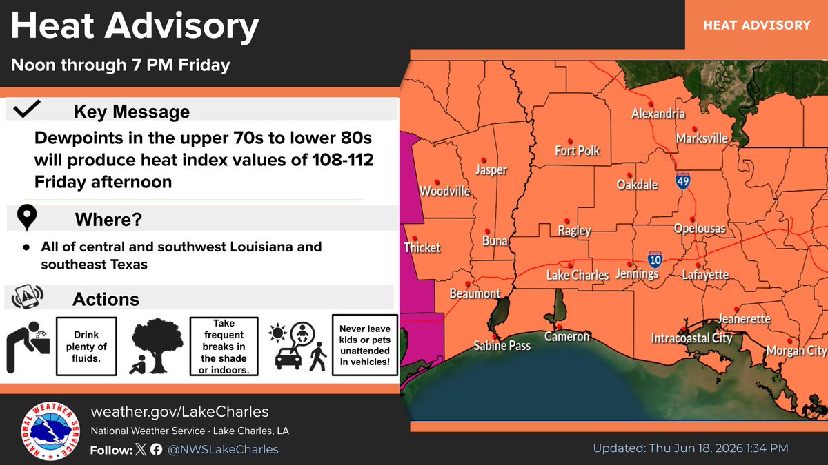
NWS Lake Charles@NWSLakeCharlesJun 18Catastrophic flooding continues across much of Avoyelles parish this afternoon and a Flood Watch remains in effect until 7 PM this evening for central Louisiana. Tomorrow the focus shifts to the heat with heat indices into the 105-110 range.112244476476
NWS Lake Charles@NWSLakeCharlesJun 18Flash Flood Warning including Marksville LA, Lecompte LA and Fifth Ward LA until 5:00 PM CDT1111263263
NWS Lake Charles@NWSLakeCharlesJun 18Flash Flood Emergency including Bunkie LA, Simmesport LA and Cottonport LA until 5:00 PM CDT3333390390
NWS Lake Charles@NWSLakeCharlesJun 18Flash Flood Emergency continues for Simmesport LA, Cottonport LA and Moreauville LA until 1:00 PM CDT22353353
NWS Lake Charles@NWSLakeCharlesJun 18Severe Thunderstorm Warning including Simmesport LA, Cottonport LA and Moreauville LA until 1:00 PM CDT11292292
NWS Lake Charles@NWSLakeCharlesJun 18Tornado Warning continues for Plaucheville LA, Dupont LA and Goudeau LA until 12:00 PM CDT305305
NWS Lake Charles@NWSLakeCharlesJun 18Tornado Warning including Cottonport LA, Evergreen LA and Plaucheville LA until 12:00 PM CDT11357357
NWS Lake Charles@NWSLakeCharlesJun 18Severe Thunderstorm Warning including Simmesport LA, Cottonport LA and Moreauville LA until 12:00 PM CDT281281
NWS Lake Charles@NWSLakeCharlesJun 18Severe Thunderstorm Warning continues for Simmesport LA, Cottonport LA and Mansura LA until 11:00 AM CDT263263