Log inSign up
NWS Lubbock
28.2K posts
Image
user avatar
NWS Lubbock
@NWSLubbock
Official X account for the National Weather Service in Lubbock, TX. Details: weather.gov/nws_x
Lubbock, Texas
weather.gov/lub
Joined May 2012
142
Following
28.5K
Followers
  • user avatar
    NWS Lubbock
    @NWSLubbock
    4h
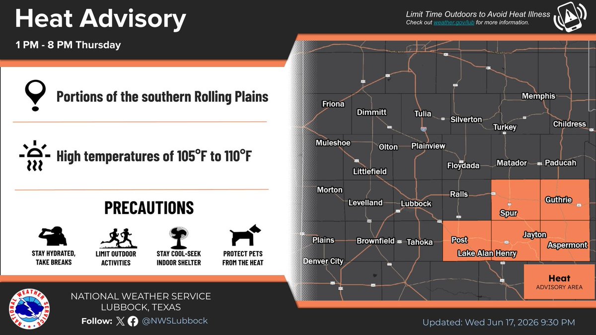
    While temperatures will be relatively cooler Thursday for much of the area behind a cold front, a Heat Advisory remains in effect from 1 PM to 8 PM for portions of the Rolling Plains for temperatures between 105° and 110°. Stay hydrated! #lubwx #txwx
    This graphic shows the Heat Advisory for Thursday.
    455
  • user avatar
    NWS Lubbock
    @NWSLubbock
    11h
    Warm overnight lows will follow after a hot day. Skies will be mostly clear with light winds. #lubwx #txwx
    This graphic shows the forecast for tonight
    469
  • user avatar
    NWS Lubbock
    @NWSLubbock
    21h
    Very hot conditions are expected to develop this afternoon with temperatures forecasted above 105°F. A Heat Advisory is in effect area-wide from 1PM through 9PM this evening. Stay hydrated and limit time outdoors to avoid heat related illnesses. #lubwx #txwx
    This graphic shows the forecast for today
    578
  • user avatar
    NWS Lubbock
    @NWSLubbock
    Jun 16
    The heat intensifies for the midweek period with most locations seeing highs of 105 degrees or warmer on Wednesday. A Heat Advisory is in effect for the entire forecast area from 1 PM to 9 PM Wednesday. Temperatures will then gradually cool off through Friday.
    This graphic shows the forecast for Tonight through Friday.
    This graphic shows the area covered by the Heat Advisory.
    707
  • user avatar
    NWS Lubbock
    @NWSLubbock
    Jun 16
    Hot temperatures to start the extended, cooling briefly through the end of the week, before becoming hot once again early next week. Precipitation chances will return to the region late week. #lubwx #txwx
    This graphic shows the extended forecast for the Caprock regions.
    601
  • user avatar
    NWS Lubbock
    @NWSLubbock
    Jun 16
    Aviso de Tormenta Severa incluye Lubbock TX, Levelland TX, Littlefield TX hasta las 10:15 PM CDT
    Este gráfico muestra la localización en el mapa de un aviso de tormenta severa. El aviso estará en efecto hasta las 10:15 PM CDT. El aviso incluye a Lubbock TX, Levelland TX, Littlefield TX. El aviso incluye el condado de Lubbock en el noroeste de Texas, el condado de el este centro de Cochran en el noroeste de Texas, el noroeste del condado de Crosby en el noroeste de Texas, el condado de Hockley en el noroeste de Texas, el suroeste del condado de Hale en el noroeste de Texas y el sureste del condado de Lamb en el noroeste de Texas. Las amenazas asociadas a este aviso son: ráfagas de viento de 60 MPH y granizo del tamaño de una pequeña canica. Hay 346,951 personas bajo este aviso incluyendo 141 escuelas y 11 hospitales.
    719
  • user avatar
    NWS Lubbock
    @NWSLubbock
    Jun 16
    Severe Thunderstorm Warning including Lubbock TX, Levelland TX and Littlefield TX until 10:15 PM CDT
    This graphic displays a severe thunderstorm warning plotted on a map. The warning is in effect until 10:15 PM CDT. The warning includes Lubbock TX, Levelland TX and Littlefield TX.  This warning is for Lubbock County in northwestern Texas, East central Cochran County in northwestern Texas, Northwestern Crosby County in northwestern Texas, Hockley County in northwestern Texas, Southwestern Hale County in northwestern Texas and Southeastern Lamb County in northwestern Texas. The threats associated with this warning are wind gusts up to 60 MPH and pea sized hail. There are 346,951 people in the warning along with 141 schools and 11 hospitals.
    753
  • user avatar
    NWS Lubbock
    @NWSLubbock
    Jun 16
    Aviso de Tormenta Severa incluye Littlefield TX, Morton TX, Sudan TX hasta las 9:15 PM CDT
    Este gráfico muestra la localización en el mapa de un aviso de tormenta severa. El aviso estará en efecto hasta las 9:15 PM CDT. El aviso incluye a Littlefield TX, Morton TX, Sudan TX. El aviso incluye el condado de Bailey en el noroeste de Texas, el condado de Cochran en el noroeste de Texas, el noroeste del condado de Hockley en el noroeste de Texas y el sur del condado de Lamb en el noroeste de Texas. Las amenazas asociadas a este aviso son: ráfagas de viento de 60 MPH y granizo del tamaño de una pequeña canica. Hay 10,570 personas bajo este aviso incluyendo 17 escuelas y 2 hospitales.
    595
  • user avatar
    NWS Lubbock
    @NWSLubbock
    Jun 16
    Severe Thunderstorm Warning including Littlefield TX, Morton TX and Sudan TX until 9:15 PM CDT
    This graphic displays a severe thunderstorm warning plotted on a map. The warning is in effect until 9:15 PM CDT. The warning includes Littlefield TX, Morton TX and Sudan TX.  This warning is for Bailey County in northwestern Texas, Cochran County in northwestern Texas, Northwestern Hockley County in northwestern Texas and Southern Lamb County in northwestern Texas. The threats associated with this warning are wind gusts up to 60 MPH and pea sized hail. There are 10,570 people in the warning along with 17 schools and 2 hospitals.
    637
  • user avatar
    NWS Lubbock
    @NWSLubbock
    Jun 16
    Aviso de Tormenta Severa incluye Muleshoe TX, Friona TX, Bovina TX hasta las 8:30 PM CDT. ¡Esta tormenta contiene ráfagas de vientos de 70 MPH!
    Este gráfico muestra la localización en el mapa de un aviso de tormenta severa. El aviso estará en efecto hasta las 8:30 PM CDT. El aviso incluye a Muleshoe TX, Friona TX, Bovina TX. El aviso incluye el condado de Bailey en el noroeste de Texas, el condado de Parmer en el Panhandle de Texas y el noroeste del condado de Lamb en el noroeste de Texas. Las amenazas asociadas a este aviso son: ráfagas de viento de 70 MPH y granizo del tamaño de una pequeña canica. Hay 17,197 personas bajo este aviso incluyendo 16 escuelas y 2 hospitales.
    474
  • user avatar
    NWS Lubbock
    @NWSLubbock
    Jun 16
    Severe Thunderstorm Warning including Muleshoe TX, Friona TX and Bovina TX until 8:30 PM CDT. This storm will contain wind gusts to 70 MPH!
    This graphic displays a severe thunderstorm warning plotted on a map. The warning is in effect until 8:30 PM CDT. The warning includes Muleshoe TX, Friona TX and Bovina TX.  This warning is for Bailey County in northwestern Texas, Parmer County in the Panhandle of Texas and Northwestern Lamb County in northwestern Texas. The threats associated with this warning are wind gusts up to 70 MPH and pea sized hail. There are 17,197 people in the warning along with 16 schools and 2 hospitals.
    507
  • user avatar
    NWS Lubbock
    @NWSLubbock
    Jun 15
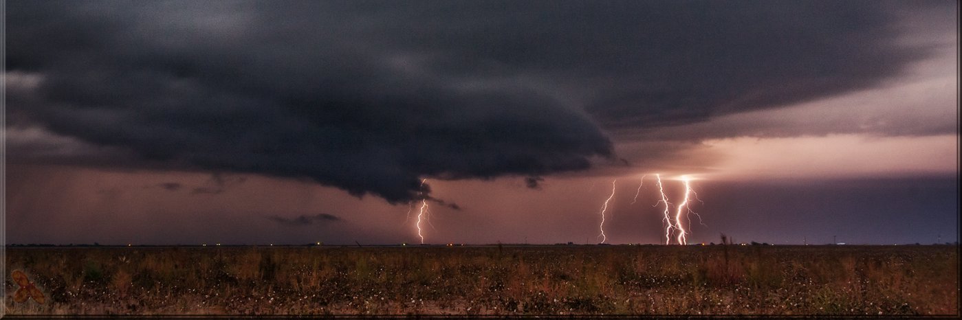
    Additional chances for storms will exist this evening mainly on the Caprock. Some storms could be strong to severe and produce wind gusts up to 65 mph. Overnight lows will be in the upper 50s to mid 60s. #lubwx #txwx
    This graphic shows the forecast for tonight.
    696
  • user avatar
    NWS Lubbock
    @NWSLubbock
    Jun 15
    A few showers will linger across the Caprock regions this morning, before warming up into the 80s this afternoon. Additional chances for storms will exist late this afternoon through early morning hours Tuesday. #lubwx #txwx
    This graphic shows the forecast for Monday
    620

New to X?

Sign up now to get your own personalized timeline!

Create account

By signing up, you agree to the Terms of Service and Privacy Policy, including Cookie Use.

Terms of Service|Privacy Policy|Cookie Policy|Accessibility|Ads info|© 2026 X Corp.
Don't miss what's happening
People on X are the first to know.
Log inSign up
Advertisement
Advertisement