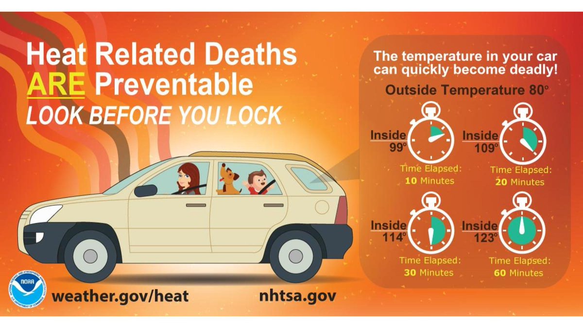
Log inSign up
NWS Melbourne
27.3K posts
Image
user avatar
NWS Melbourne
@NWSMelbourne
Official X account for the National Weather Service Melbourne, FL. Details: weather.gov/nws_x
Melbourne, Florida
weather.gov/mlb/
Joined May 2012
372
Following
56K
Followers
  • Pinned
    user avatar
    NWS Melbourne
    @NWSMelbourne
    May 10
    📢 Mark your calendar! NWS meteorologists across FL are hosting 4 days of free, virtual training to help you prepare for hurricane season July 27-30th! Topics: ✅ Getting Ready ✅ Hunker Down ✅ Post Storm Safety ✅ Lessons Learned 🖱 Register today: weather.gov/jax/fttw2026
    Post advertising Florida Tropical Training Week. Presented by meteorologists from the National Weather Service. Hosted July 27th to July 30th, with three times each day. The training is free, virtual, and covers getting ready, hunkering down, post storm safety, and lessons learned.
    4.7K
  • user avatar
    NWS Melbourne
    @NWSMelbourne
    2h
    Jun 19 | There is a Marginal (level 1 of 5) Risk for thunderstorms to become severe between 3PM-11PM across all ECFL. Before that & where storms don't develop, hot & muggy again. Another Heat Advisory has been issued for the area from 11AM-7PM. Moderate risk of rip currents.
    Today's weather outlook for East Central Florida. Still hot and muggy. There is a Marginal (level 1 of 5) Risk for thunderstorms to become severe between 3 PM and 10 PM. Medium to high (40-70%) shower and storm chances, especially along the sea breeze collision where it sets up. Afternoon highs in the mid to upper 90s combined with humidity will produce heat indices between 105 and 110, and another Heat Advisory has been issued from 11 AM through 7 PM for the whole area. A moderate risk of rip currents continues at the beaches. Always swim near a life guard, and never swim alone.
    There is a Marginal Risk for severe storms across all of East Central Florida today. Primary hazards are isolated damaging wind gusts, locally heavy rainfall, and frequent lightning strikes. Hail up to 1 inch will also be possible, and a brief tornado or waterspout cannot be ruled out along boundary collisions.
     Another Heat Advisory has been issued for all of East Central Florida from 11 AM through 7 PM. High temperatures in the mid to upper 90s combined with humidity will produce Heat Index (feels-like) temperatures from 105 to 110.
    Heat related death are preventable. Never leave children or pets in vehicles without air conditioning for any period of time. Even when it's only 80 degrees outside, temperatures inside cars can climb to 100 in just 10 minutes. Look before you lock!
    558
  • user avatar
    NWS Melbourne
    @NWSMelbourne
    11h
    A special weather statement has been issued for Orlando FL, Conway FL and Azalea Park FL until 7:45 PM EDT
    This graphic displays a special weather statement plotted on a map. The statement is in effect until 7:45 PM EDT.  The statement includes Orlando FL, Conway FL and  Azalea Park FL.  A STRONG THUNDERSTORM WILL IMPACT SOUTHWESTERN ORANGE COUNTY THROUGH 745 PM EDT. The threats associated with this storm are wind gusts up to 50 MPH and pea sized hail. Seek shelter in a sturdy structure until the storm passes.
    749
  • user avatar
    NWS Melbourne
    @NWSMelbourne
    12h
    Aviso Especial Marítimo continúa Playa Flagler a Línea del Condado Volusia-Brevard 0-20 mn hasta las 7:45 PM EDT
    Este gráfico muestra la localización en el mapa de un Aviso Especial Marítimo. El aviso estará en efecto hasta las 7:45 PM EDT. El aviso incluye a Playa Flagler a Línea del Condado Volusia-Brevard 0-20 mn. Las amenazas asociadas a este aviso son: ráfagas de vientos de mayor de 40 nudos yno se espera granizo. Las trombas marinas no son esperadas. Alto oleaje. Busque un puerto seguro y tome medidas de precaución.
    685
  • user avatar
    NWS Melbourne
    @NWSMelbourne
    12h
    Special Marine Warning continues for the Flagler Beach to Volusia-Brevard County Line 0-20 nm until 7:45 PM EDT
    This graphic displays a special marine warning plotted on a map. The warning is in effect until 7:45 PM EDT. The warning includes Flagler Beach to Volusia-Brevard County Line 0-20 nm. The threats associated with this warning are wind gusts greater than 40kts and no hail expected.Waterspouts are not expected. Steep waves can be expected. Seek safe harbor and take protective actions.
    640
  • user avatar
    NWS Melbourne
    @NWSMelbourne
    12h
    A special weather statement has been issued for Daytona Beach FL, Ormond Beach FL and South Daytona FL until 7:15 PM EDT
    This graphic displays a special weather statement plotted on a map. The statement is in effect until 7:15 PM EDT.  The statement includes Daytona Beach FL, Ormond Beach FL and  South Daytona FL.  A STRONG THUNDERSTORM WILL IMPACT NORTH CENTRAL VOLUSIA COUNTY THROUGH 715 PM EDT. The threats associated with this storm are wind gusts up to 50 MPH and pea sized hail. Seek shelter in a sturdy structure until the storm passes.
    612
  • user avatar
    NWS Melbourne
    @NWSMelbourne
    12h
    Aviso Especial Marítimo incluye Playa Flagler a Línea del Condado Volusia-Brevard 0-20 mn hasta las 7:45 PM EDT
    Este gráfico muestra la localización en el mapa de un Aviso Especial Marítimo. El aviso estará en efecto hasta las 7:45 PM EDT. El aviso incluye a Playa Flagler a Línea del Condado Volusia-Brevard 0-20 mn. Las amenazas asociadas a este aviso son: ráfagas de vientos de mayor de 34 nudos yno se espera granizo. Las trombas marinas no son esperadas. Alto oleaje. Busque un puerto seguro y tome medidas de precaución.
    537
  • user avatar
    NWS Melbourne
    @NWSMelbourne
    12h
    Special Marine Warning including the Flagler Beach to Volusia-Brevard County Line 0-20 nm until 7:45 PM EDT
    This graphic displays a special marine warning plotted on a map. The warning is in effect until 7:45 PM EDT. The warning includes Flagler Beach to Volusia-Brevard County Line 0-20 nm. The threats associated with this warning are wind gusts greater than 34kts and no hail expected.Waterspouts are not expected. Steep waves can be expected. Seek safe harbor and take protective actions.
    580
  • user avatar
    NWS Melbourne
    @NWSMelbourne
    12h
    Aviso de Tormenta Severa incluye Poinciana FL, Campbell FL, Intercession City FL hasta las 6:45 PM EDT
    Este gráfico muestra la localización en el mapa de un aviso de tormenta severa. El aviso estará en efecto hasta las 6:45 PM EDT. El aviso incluye a Poinciana FL, Campbell FL, Intercession City FL. El aviso incluye el noroeste del condado de Osceola en el este centro de Florida. Las amenazas asociadas a este aviso son: ráfagas de viento de 60 MPH y granizo del tamaño de una pequeña canica. Hay 70,648 personas bajo este aviso incluyendo 13 escuelas y 0 hospitales.
    508
  • user avatar
    NWS Melbourne
    @NWSMelbourne
    12h
    Severe Thunderstorm Warning including Poinciana FL, Campbell FL and Intercession City FL until 6:45 PM EDT
    This graphic displays a severe thunderstorm warning plotted on a map. The warning is in effect until 6:45 PM EDT. The warning includes Poinciana FL, Campbell FL and Intercession City FL.  This warning is for Northwestern Osceola County in east central Florida. The threats associated with this warning are wind gusts up to 60 MPH and pea sized hail. There are 70,648 people in the warning along with 13 schools and 0 hospitals.
    518
  • user avatar
    NWS Melbourne
    @NWSMelbourne
    12h
    A special weather statement has been issued for Kissimmee FL, Poinciana FL and Campbell FL until 7:00 PM EDT
    This graphic displays a special weather statement plotted on a map. The statement is in effect until 7:00 PM EDT.  The statement includes Kissimmee FL, Poinciana FL and  Campbell FL.  A STRONG THUNDERSTORM WILL IMPACT SOUTH CENTRAL ORANGE AND NORTHWESTERN OSCEOLA COUNTIES THROUGH 700 PM EDT. The threats associated with this storm are wind gusts up to 55 MPH and pea sized hail. Seek shelter in a sturdy structure until the storm passes.
    539
  • user avatar
    NWS Melbourne
    @NWSMelbourne
    13h
    A special weather statement has been issued for De Leon Springs FL, Barberville FL and Eldridge FL until 6:15 PM EDT
    This graphic displays a special weather statement plotted on a map. The statement is in effect until 6:15 PM EDT.  The statement includes De Leon Springs FL, Barberville FL and  Eldridge FL.  A STRONG THUNDERSTORM WILL IMPACT NORTHWESTERN VOLUSIA COUNTY THROUGH 615 PM EDT. The threats associated with this storm are wind gusts up to 50 MPH and no hail is expected. Seek shelter in a sturdy structure until the storm passes.
    519
  • user avatar
    NWS Melbourne
    @NWSMelbourne
    14h
    A special weather statement has been issued for Eustis FL, Tavares FL and Mount Dora FL until 5:15 PM EDT
    This graphic displays a special weather statement plotted on a map. The statement is in effect until 5:15 PM EDT.  The statement includes Eustis FL, Tavares FL and  Mount Dora FL.  A STRONG THUNDERSTORM WILL IMPACT CENTRAL LAKE COUNTY THROUGH 515 PM EDT. The threats associated with this storm are wind gusts up to 50 MPH and pea sized hail. Seek shelter in a sturdy structure until the storm passes.
    647

New to X?

Sign up now to get your own personalized timeline!

Create account

By signing up, you agree to the Terms of Service and Privacy Policy, including Cookie Use.

Terms of Service|Privacy Policy|Cookie Policy|Accessibility|Ads info|© 2026 X Corp.
Don't miss what's happening
People on X are the first to know.
Log inSign up
Advertisement
Advertisement