Log inSign up
NWSSanAngelo
23.9K posts
Image
user avatar
NWSSanAngelo
@NWSSanAngelo
Official Twitter account for the National Weather Service Abilene/San Angelo. Details: weather.gov/nws_x
San Angelo, Texas
weather.gov/sjt
Joined May 2012
250
Following
23.5K
Followers
  • user avatar
    NWSSanAngelo
    @NWSSanAngelo
    7h
    Monday Morning...still hot & humid. Nothing has really changed for the forecast for today. High temperatures at or near 100 for many areas, with enough humidity that heat index values of 100-110 will be possible. A Heat Advisory remains in effect for much of the area #sjtwx #xtwx
    671
  • user avatar
    NWSSanAngelo
    @NWSSanAngelo
    Jun 21
    No, you're not seeing double and there is nothing wrong with your computer or mobile device. There are now two Heat Advisories: One is in effect for the rest of today and the other for Monday afternoon and evening. #sjtwx #txwx
    Graphic on the right side is a map depicting the heat advisory for today. Text on the left provides additional details.
    Graphic on the right side is a map depicting the heat advisory for Monday. Text on the left provides additional details.
    1.7K
    user avatar
    NWSSanAngelo
    @NWSSanAngelo
    23h
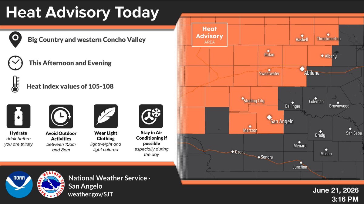
    Remember to take safety precautions against the heat today and tomorrow!
    Image
    731
  • user avatar
    NWSSanAngelo
    @NWSSanAngelo
    Jun 21
    We hope you're enjoying a wonderful Father's Day today! While celebrating be mindful of the heat this afternoon by staying hydrated in the shade and/or an air-conditioned building. Stay cool! #sjtwx #txwx
    Graphic on the right side is a map depicting the heat advisory. Text on the left provides additional details.
    559
  • user avatar
    NWSSanAngelo
    @NWSSanAngelo
    Jun 20
    The Summer Solstice occurs this weekend, marking the official start of Astronomical Summer. June 20-21st will also have the longest hours of daylight each day at 14 hours and 11 minutes. #sjtwx #txwx
    The image shows a diagram of the seasonal position of earth around the sun with an explanation of the summer solstice.
    428
  • user avatar
    NWSSanAngelo
    @NWSSanAngelo
    Jun 20
    Temperatures in the low to mid 90s are returning for today. Some isolated showers could occur over the northwest Hill Country this afternoon but nothing widespread is expected. Triple-digit heat can be expected for Fathers' Day and continuing into early next week. #sjtwx #txwx
    Tables of daily forecast high and low temperatures for selected cities across West Central Texas through the next seven days.
    383
  • user avatar
    NWSSanAngelo
    @NWSSanAngelo
    Jun 20
    Aviso de Inundación Repentina incluye San Saba County, TX hasta las 8:15 AM CDT
    Este gráfico muestra la localización en el mapa de un aviso de inundación repentina. El aviso estará en efecto hasta las 8:15 AM CDT. El aviso incluye a San Saba County, TX. El aviso incluye el sureste del condado de San Saba en el oeste centro de Texas. ¡Evite caminar o manejar su vehículo a través de áreas inundadas! ¡Muévase a un terreno más alto inmediatamente! Hay 98 personas bajo este aviso incluyendo 0 escuelas y 0 hospitales.
    264
  • user avatar
    NWSSanAngelo
    @NWSSanAngelo
    Jun 20
    Flash Flood Warning including San Saba County, TX until 8:15 AM CDT
    This graphic displays a flash flood warning plotted on a map. The warning is in effect until 8:15 AM CDT. The warning includes San Saba County, TX.  This warning is for Southeastern San Saba County in west central Texas. Avoid walking or driving through flood waters! Move immediately to higher ground! There are 98 people in the warning along with 0 schools and 0 hospitals.
    262
  • user avatar
    NWSSanAngelo
    @NWSSanAngelo
    Jun 19
    A few LCRA gauges have rainfall totals over 3 inches this morning:  Brady 11E with 3.15 inches, Richland Springs     6NNW with 3.14 inches, and at the Colorado River near Goldthwaite with 3.58 inches. #sjtwx #txwx
    2.8K
  • user avatar
    NWSSanAngelo
    @NWSSanAngelo
    Jun 19
    A couple of LCRA gauges with more than 2" hourly rainfall in McCulloch County between 840 AM & 940 AM: 2.18" at Rochelle 5 NNW, and 2.24" at Brady 11 E. #sjtwx #txwx
    302
  • user avatar
    NWSSanAngelo
    @NWSSanAngelo
    Jun 19
    Aviso de Tormenta Severa incluye San Saba TX, Cherokee TX hasta las 10:15 AM CDT
    Este gráfico muestra la localización en el mapa de un aviso de tormenta severa. El aviso estará en efecto hasta las 10:15 AM CDT. El aviso incluye a San Saba TX, Cherokee TX. El aviso incluye el sureste del condado de San Saba en el oeste centro de Texas. Las amenazas asociadas a este aviso son: ráfagas de viento de 60 MPH y granizo del tamaño de medio dólar. Hay 4,042 personas bajo este aviso incluyendo 4 escuelas y 0 hospitales.
    167
  • user avatar
    NWSSanAngelo
    @NWSSanAngelo
    Jun 19
    Severe Thunderstorm Warning including San Saba TX and Cherokee TX until 10:15 AM CDT
    This graphic displays a severe thunderstorm warning plotted on a map. The warning is in effect until 10:15 AM CDT. The warning includes San Saba TX and Cherokee TX.  This warning is for Southeastern San Saba County in west central Texas. The threats associated with this warning are wind gusts up to 60 MPH and half dollar sized hail. There are 4,042 people in the warning along with 4 schools and 0 hospitals.
    173
  • user avatar
    NWSSanAngelo
    @NWSSanAngelo
    Jun 19
    Aviso de Inundación Repentina incluye San Saba TX, Richland Springs TX, Harkeyville TX hasta las 12:45 PM CDT
    Este gráfico muestra la localización en el mapa de un aviso de inundación repentina. El aviso estará en efecto hasta las 12:45 PM CDT. El aviso incluye a San Saba TX, Richland Springs TX, Harkeyville TX. El aviso incluye el este del condado de McCulloch en el oeste centro de Texas y el condado de San Saba en el oeste centro de Texas. ¡Evite caminar o manejar su vehículo a través de áreas inundadas! ¡Muévase a un terreno más alto inmediatamente! Hay 5,434 personas bajo este aviso incluyendo 6 escuelas y 0 hospitales.
    151
  • user avatar
    NWSSanAngelo
    @NWSSanAngelo
    Jun 19
    Flash Flood Warning including San Saba TX, Richland Springs TX and Harkeyville TX until 12:45 PM CDT
    This graphic displays a flash flood warning plotted on a map. The warning is in effect until 12:45 PM CDT. The warning includes San Saba TX, Richland Springs TX and Harkeyville TX.  This warning is for Eastern McCulloch County in west central Texas and San Saba County in west central Texas. Avoid walking or driving through flood waters! Move immediately to higher ground! There are 5,434 people in the warning along with 6 schools and 0 hospitals.
    181

New to X?

Sign up now to get your own personalized timeline!

Create account

By signing up, you agree to the Terms of Service and Privacy Policy, including Cookie Use.

Terms·Privacy·Cookies·Accessibility·Ads Info·© 2026 X Corp.
Don't miss what's happening
People on X are the first to know.
Log inSign up
Advertisement
Advertisement