It was a warm to hot day, with many areas pushing into the 90s. Here's a map of highs in select locations for today.
If you are interested in seeing your location, you can look to this map: weather.gov/wrh/hazards?ob…#wawx#idwx
Our AQ partners have published a blog post with updated information on fires and air quality across Washington state. Here is a link to the updated blog post which includes info on a Red Flag Warning issued by NWS for Tuesday: wasmoke.blogspot.com/2026/06/smoke-…#wawx
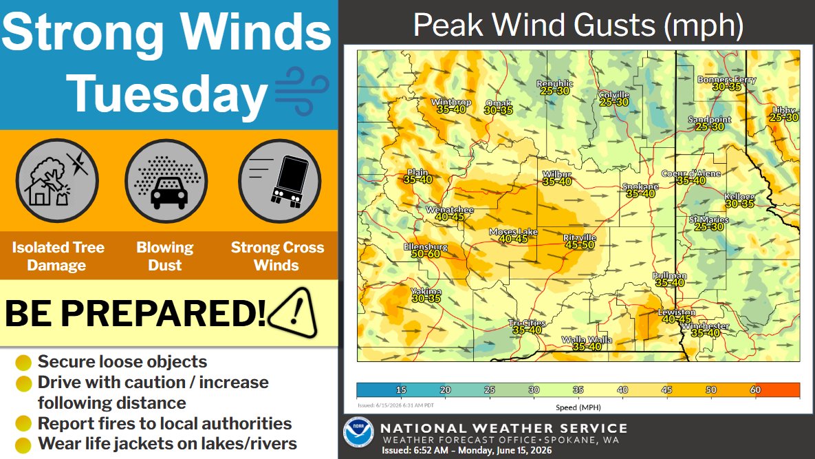
Corrected graphic for previous post: Strong winds are expected with a cold front passage on Tuesday. Winds will be capable of breaking small tree limbs, result in periods of blowing dust, and hazardous travel to high profile vehicles. Prepare for strong winds! #wawx#idwx
Strong winds are expected with a cold front passage on Tuesday. Winds will be capable of breaking small tree limbs, result in periods of blowing dust, and hazardous travel to high profile vehicles. Use caution and prepare for strong winds on Tuesday. #wawx#idwx
Very warm temperatures heading into Monday with highs up into the mid 80s to mid 90s. This will result in widespread moderate HeatRisk to the Inland Northwest and even major HeatRisk in portions of central Washington. #wawx#idwx
Heads up: Critical fire weather is expected Tuesday, June 16. West winds of 35-50 mph and low humidity mean any new grass fires could spread rapidly. Please do your part to prevent sparks. Secure trailer chains, don't park on dry grass, and follow all local burn bans.
Here is a current radar loop. Showers and thunderstorms are moving across northeast Washington and the N ID Panhandle. They will continue moving southeast through the day. Main impacts with any thunderstorms will be gusty outflow winds up to 40 mph and pea sized hail. #wawx#idwx
An El Niño Advisory has been issued and you may have recently heard the term "Super El Niño". One of our meteorologists explains the terms NOAA uses to describe ENSO intensity and some basics of what El Niño is and is not.
The forecast calls for El Niño to strengthen into the
On Friday, winds will increase down the Okanogan Valley and gust up to 40 mph through the afternoon hours. The combination of low relative humidity will result in increased fire concerns, particularly in fine fuels where fires can spread rapidly. #wawx
🔥 Did you know embers can travel miles ahead of a wildfire and ignite homes? As wildfire season approaches, keep your gutters clean and keep the first 5 feet around your house free of dry debris to protect your home. Learn more at dnr.wa.gov
Here's your wind gust forecast for today. Breezy again, but speeds will decrease later this afternoon into tonight.
Details at weather.gov/spokane#wawx#idwx