Log inSign up
Tennessee Emergency Management Agency (TEMA)
6,476 posts
Image
user avatar
Tennessee Emergency Management Agency (TEMA)
@TennesseeEMA
The Tennessee Emergency Management Agency is responsible for preparedness, response, mitigation and recovery from disasters. Please dial 9-1-1 in an emergency.
State of Tennessee
tn.gov/tema
Joined May 2009
463
Following
30.2K
Followers
  • user avatar
    Tennessee Emergency Management Agency (TEMA)
    @TennesseeEMA
    12h
    Resilience, one pixel at a time. Most people see the emergency. We see the planning, training, coordination, and commitment behind it. The work begins before the storm and continues long after the headlines fade. 24/7/365. #ReadyTN #TEMA75
    Image
    Image
    Image
    Image
    475
  • Tennessee Emergency Management Agency (TEMA) reposted
    user avatar
    NWS Morristown
    @NWSMorristown
    15h
    A special weather statement has been issued for Murphy NC, Benton TN and Ducktown TN until 4:45 PM EDT
    This graphic displays a special weather statement plotted on a map. The statement is in effect until 4:45 PM EDT.  The statement includes Murphy NC, Benton TN and  Ducktown TN.  STRONG THUNDERSTORMS WILL IMPACT CHEROKEE, SOUTHEASTERN BRADLEY, POLK and SOUTH CENTRAL MCMINN AND SOUTHWESTERN MONROE COUNTIES THROUGH 445 PM EDT. The threats associated with this storm are wind gusts up to 40 MPH and no hail is expected. Seek shelter in a sturdy structure until the storm passes.
    807
  • Tennessee Emergency Management Agency (TEMA) reposted
    user avatar
    Williamson County Emergency Management Agency
    @WCTNEMA
    20h
    📻⚡ What if your cell phone didn't work during an emergency? Next weekend, learn how communication can continue when power goes out or internet or cell service go down. Stop by the FREE WCARES Field Day Open House and experience emergency communications in action! 🗓 Saturday,
    Promotional graphic for the WCARES Ham Radio Field Day public open house. The design features the Williamson County Amateur Radio Emergency Service (WCARES) logo and large yellow text reading "Ham Radio Field Day." Event details include: "24-Hour Amateur Radio Exercise," "BrightStone Campus, 3000 BrightStone Parkway, Franklin, TN," and "Public Open House – Saturday, June 27, 1–5 PM." Diamond-shaped photos show portable amateur radio equipment, radio operators using communications equipment, the WCARES display booth, and volunteers interacting with visitors. The graphic has a black, white, and gold color scheme with decorative gold dot accents.
    500
  • Tennessee Emergency Management Agency (TEMA) reposted
    user avatar
    NWS Morristown
    @NWSMorristown
    17h
    SPC has issued an Mesoscale Discussion for our northern areas with a 60% Watch Probability. A few strong to severe storms are probable in the highlighted areas through this afternoon/evening. Read more here spc.noaa.gov/products/md/md…
    Image
    1.1K
  • Tennessee Emergency Management Agency (TEMA) reposted
    user avatar
    NWS Morristown
    @NWSMorristown
    20h
    A special weather statement has been issued for Bristol TN, Bristol VA and Abingdon VA until 12:45 PM EDT
    This graphic displays a special weather statement plotted on a map. The statement is in effect until 12:45 PM EDT.  The statement includes Bristol TN, Bristol VA and  Abingdon VA.  The threats associated with this storm are wind gusts up to 50 MPH and no hail is expected. Seek shelter in a sturdy structure until the storm passes.
    902
  • Tennessee Emergency Management Agency (TEMA) reposted
    user avatar
    NWS Morristown
    @NWSMorristown
    19h
    A special weather statement has been issued for Bristol TN, Bristol VA and Abingdon VA until 1:00 PM EDT
    This graphic displays a special weather statement plotted on a map. The statement is in effect until 1:00 PM EDT.  The statement includes Bristol TN, Bristol VA and  Abingdon VA.  GUSTY SHOWERS WILL IMPACT NORTHEASTERN SULLIVAN AND SOUTHWESTERN WASHINGTON COUNTIES AND THE CITY OF BRISTOL THROUGH 100 PM EDT. The threats associated with this storm are wind gusts up to 50 MPH and no hail is expected. Seek shelter in a sturdy structure until the storm passes.
    716
  • Tennessee Emergency Management Agency (TEMA) reposted
    user avatar
    NWS Morristown
    @NWSMorristown
    19h
    A special weather statement has been issued for Chattanooga TN, East Ridge TN and Soddy-Daisy TN until 12:00 PM CDT
    This graphic displays a special weather statement plotted on a map. The statement is in effect until 12:00 PM CDT.  The statement includes Chattanooga TN, East Ridge TN and  Soddy-Daisy TN.  The threats associated with this storm are wind gusts up to 50 MPH and no hail is expected. Seek shelter in a sturdy structure until the storm passes.
    816
  • user avatar
    Tennessee Emergency Management Agency (TEMA)
    @TennesseeEMA
    Jun 17
    Traveling this weekend? Storms starting Thursday could bring strong winds & heavy rain. Stay weather-aware: check forecasts, monitor along your route, enable alerts & plan alternates. Pack a roadside kit, share your route & plan for pets. #ReadyTN #ReadySetPet
    Image
    398
  • Tennessee Emergency Management Agency (TEMA) reposted
    user avatar
    National Weather Service
    @NWS
    Jun 17
    Excessive rainfall may produce considerable, potentially life-threatening, flash and urban flooding across the lower Mississippi River Valley and central Great Lakes region through tonight. The heavy rainfall is expected to shift into southern Mississippi, Alabama, Georgia, and
    NOAA graphic showing the 3-day excessive rainfall outlook tied to Potential Tropical Cyclone One across the Gulf Coast and Southeast. The greatest flash flooding threat (moderate risk, red) extends from southeast Texas near Houston across southern Louisiana, including Lake Charles and New Orleans, through coastal Mississippi and Alabama, reaching inland toward Mobile and Montgomery. A broader slight risk area (yellow) covers much of the surrounding Gulf Coast and Southeast, stretching west into east Texas and north into parts of Arkansas, Tennessee, Georgia, and the Carolinas. Smaller inset maps show how the heavy rain and flooding threat shifts eastward from Thursday through Saturday morning. The forecast highlights a multi-day risk of tropical downpours and potentially significant flash flooding along the central Gulf Coast.
    Pictured: a car submerged in water next to a sidewalk. Text: You don't know how deep the water is. Turn around, don't drown.
    19K
  • Tennessee Emergency Management Agency (TEMA) reposted
    user avatar
    NWS Morristown
    @NWSMorristown
    Jun 17
    Still a low chance for a strong/severe ⛈️ tomorrow, with a low risk of flooding, but rainfall forecasts over the broad East Tennessee region have trended down. Thursday may be quite breezy outside of any shower or storm. Friday then looks to clear up for the weekend.
    Dry Wednesday followed by a few scattered showers and thunderstorms on Thursday. A strong to low end severe thunderstorm is possible, with winds the hazard. Breezy on Thursday. A few showers may linger into Friday, but generally clouds to decrease through the day on Friday. Temperatures to remain in the 80s during the days, upper 60s in the mornings. Flood risk very low.
    1.3K
  • Tennessee Emergency Management Agency (TEMA) reposted
    user avatar
    NWS Nashville
    @NWSNashville
    Jun 17
    We've got one more day of rain-free weather before rain & storms return to Middle TN on Thursday. There is a low chance (mostly a level 1 out of 5) of severe storms Thursday, from mid afternoon into the early evening, with damaging winds & heavy rainfall being the main threats.
    The graphic shows a low chance (level 1 or 2 out of 5) of severe storms on Thursday, mainly during the afternoon. The greatest risk is going to occur generally north of I-40. The primary risks are going to be damaging winds and also heavy rainfall.
    4.1K
  • Tennessee Emergency Management Agency (TEMA) reposted
    user avatar
    Shelby County Health
    @ShelbyTNHealth
    Jun 16
    Summer travel is exciting but air quality changes from city to city. Before your next road trip or vacation, check AirNow.gov so your family can breathe easy wherever you go. epa.gov/clean-air-act-…
    Image
    Image
    369
  • Tennessee Emergency Management Agency (TEMA) reposted
    user avatar
    National Weather Service
    @NWS
    Jun 16
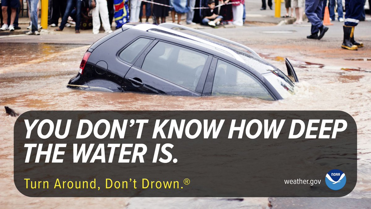
    Areas of very heavy rain the next few days will bring potential flash flooding along the western and central Gulf coast and into the deep south. Remember: more than 50% of all flood fatalities are vehicle-related. You never know how deep the water is or if the road has been
    Pictured: a car submerged in water next to a sidewalk. Text: You don't know how deep the water is. Turn around, don't drown.
    NOAA graphic showing a 3-Day (Tuesday–Thursday) Excessive Rainfall Outlook for the southern U.S. A broad slight risk area (yellow) stretches from south Texas across Louisiana, Mississippi, Alabama, and into parts of the Southeast. A moderate risk area (red) highlights the greatest flash flooding concern along the Texas and Louisiana Gulf Coast, extending from Brownsville through Houston, across southern Louisiana near New Orleans, and inland through parts of Mississippi and Alabama. Major cities labeled include San Antonio, Austin, Dallas, Houston, Shreveport, Little Rock, Memphis, Atlanta, New Orleans, and Brownsville. The graphic emphasizes an elevated threat for multiple rounds of heavy rainfall and potential flash flooding, especially near the western and central Gulf Coast through Thursday.
    18K

New to X?

Sign up now to get your own personalized timeline!

Create account

By signing up, you agree to the Terms of Service and Privacy Policy, including Cookie Use.

Terms of Service|Privacy Policy|Cookie Policy|Accessibility|Ads info|© 2026 X Corp.
Don't miss what's happening
People on X are the first to know.
Log inSign up
Advertisement
Advertisement