Log inSign up
Jason D Farhang
9,920 posts
Image
user avatar
Jason D Farhang
@jason61987
Meteorologist Climate 101 With Jason
Sherman Oaks, Los Angeles
facebook.com/Climate101with…
Born June 19, 1987
Joined November 2008
257
Following
12.5K
Followers
  • user avatar
    Jason D Farhang
    @jason61987
    Feb 3, 2024
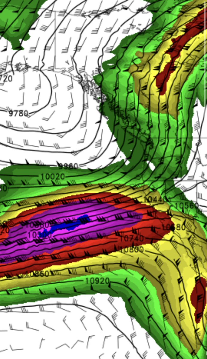
    Saturday, February 3, 2024, 9:36 AM PST: According to the IR satellite, there is a significant intensification process currently taking place with our incoming Pacific storm. This will result in a substantial amount of rainfall, ranging from 4.5 to 10.5 inches, across the entire
    Image
    00:00
    215K
  • user avatar
    Jason D Farhang
    @jason61987
    Jan 31, 2024
    On Tuesday, January 30, 2024 at 4:59 PM PST: A low-pressure system with a reading of 963 millibars has undergone an impressive intensification within the past 24 hours. It has transitioned from a remarkable 990 millibar low, and this process of rapid intensification continues to
    Image
    00:00
    188K
  • user avatar
    Jason D Farhang
    @jason61987
    Mar 10, 2025
    Monday, March 10, 2025, 8:56 AM PDT: A storm is approaching Southern California. The weather will start changing later this afternoon at 3 PM as this cut-off low has now fixated its trajectory towards Los Angeles, California later on tonight mostly after 7 PM into Tuesday
    Image
    00:00
    158K
  • user avatar
    Jason D Farhang
    @jason61987
    Jan 20, 2024
    Friday, January 19, 2024, 6:22 PM PST: In the last six hours there has been a change in the trajectory of all storms. This is still developing, but it looks like the storms are strengthening much more than previously thought. Looking like a true El Niño pattern now for the state
    Image
    00:00
    218K
  • user avatar
    Jason D Farhang
    @jason61987
    Jan 29, 2024
    Monday, January 29, 2024, 5:34 AM PST, I would like to inform you that California, particularly Southern California, should prepare for an increased amount of rainfall. This upcoming February, we can expect precipitation levels that surpass the usual average. This weather pattern
    Image
    Image
    201K
  • user avatar
    Jason D Farhang
    @jason61987
    Feb 4, 2024
    Sunday, February 4, 2024, 6:00 AM PST: A powerful unprecedented 975 mb low is located just 125 miles off Lompoc, CA. Damaging southerly surface winds have begun across the Central Coast to Santa Barbara counties. Reports of wind gusts knocking out larger trees arrived at 3:00
    Image
    00:00
    143K
  • user avatar
    Jason D Farhang
    @jason61987
    Mar 1, 2024
    Ladies and gentlemen, I would like to inform you that today, on this fine Friday, March 1, 2024, at 9:48 AM PST, I observed an interesting meteorological phenomenon. The Polar jet stream has been clearly defined on the infrared satellite view, as it forcefully collides with the
    Image
    00:00
    151K
  • user avatar
    Jason D Farhang
    @jason61987
    Aug 23, 2024
    Friday, August 23, 2024, 7:14 AM PDT: The coldest weather day for August standards possibly in 34 years for Northern California, Oregon, and Washington State. Even central California and Southern California are feeling the difference this morning. This is all thanks to a very
    Image
    00:00
    39K
  • user avatar
    Jason D Farhang
    @jason61987
    Sep 7, 2023
    #Jova Wednesday, September 6, 2023, 9:33 PM PDT: Jova is now a horrific category five monster with sustained winds of 160 mph moving NNW at 10 mph. This is the strongest storm on earth right now this is eerily, similar to Linda in September 1997 when she also became a
    Image
    00:00
    109K
  • user avatar
    Jason D Farhang
    @jason61987
    Jan 6, 2025
    Monday, January 6, 2025, 7:00 AM PDT: There is no backing down on the strength of this powerful Santa Ana wind situation that arrives tomorrow at 7PM through Wednesday at 3PM. E/NE gusts remain 58MPH - 95MPH. Damage is very likely prepared today. Today is the day to get
    Image
    Image
    93K
  • user avatar
    Jason D Farhang
    @jason61987
    Nov 19, 2024
    Tuesday, November 19, 2024, 10:55 AM PDT: Atmospheric infrared satellite view shows bomb cyclone maturing now and intensifying over the Pacific Ocean is an incredible spectacle to witness in November. #CAwx #AtmosphericRiver #AtmosphericRiver #BombCyclone
    Image
    00:00
    65K
  • user avatar
    Jason D Farhang
    @jason61987
    Feb 5, 2024
    This is not good! This is why we have the purple code for major flood issues.
    user avatar
    Maria Bruggere
    @MariaBruggere
    Feb 5, 2024
    LA River at Centinela in Playa Vista 😳
    Image
    00:00
    Readers added context
    This is Ballona Creek, not the LA River, since it is the only waterway that flows through Playa Vista. maps.app.goo.gl/BfiK1Ju2BN83v4…
    133K
  • user avatar
    Jason D Farhang
    @jason61987
    Mar 6, 2025
    My Mom Passed Away 💔
    Image
    23K
  • user avatar
    Jason D Farhang
    @jason61987
    Feb 4, 2024
    Saturday, February 3, 2024, 7:13 PM PST: The “Baroclinic Leaf” is currently undergoing significant and rapid intensification this Saturday evening as it moves closer to Southern California. Over the past 24 hours, the main low-pressure system has dropped from 996 mb to 984 mb.
    Image
    00:00
    87K

New to X?

Sign up now to get your own personalized timeline!

Create account

By signing up, you agree to the Terms of Service and Privacy Policy, including Cookie Use.

Terms·Privacy·Cookies·Accessibility·Ads Info·© 2026 X Corp.
Don't miss what's happening
People on X are the first to know.
Log inSign up
Advertisement
Advertisement