Log inSign up
Met Office - SW England
2,072 posts
Image
user avatar
Met Office - SW England
@metofficeSWEng
Met Office weather warnings for SW England, with additional information from Met Office advisors and meteorologists. For questions, tweet @metoffice
South west England
metoffice.gov.uk/public/weather…
Joined January 2010
211
Following
16.2K
Followers
  • user avatar
    Met Office - SW England
    @metofficeSWEng
    Feb 17, 2022
    Red warning of wind affecting South West England metoffice.gov.uk/weather/warnin…
    Image
  • user avatar
    Met Office - SW England
    @metofficeSWEng
    Dec 6, 2024
    Red warning of wind affecting South West England metoffice.gov.uk/weather/warnin…
    Image
    16K
  • user avatar
    Met Office - SW England
    @metofficeSWEng
    Jan 8, 2025
    Amber warning of snow affecting South West England metoffice.gov.uk/weather/warnin…
    Image
    31K
  • user avatar
    Met Office - SW England
    @metofficeSWEng
    May 15, 2022
    ⛈️ Thunderstorms in the English Channel are moving north towards southern England Localised heavy rain, lightning and hail are likely across parts of Dorset, Hampshire and the Isle of Wight over the next 2-3 hours Stay #WeatherAware
    Image
  • user avatar
    Met Office - SW England
    @metofficeSWEng
    Sep 4, 2022
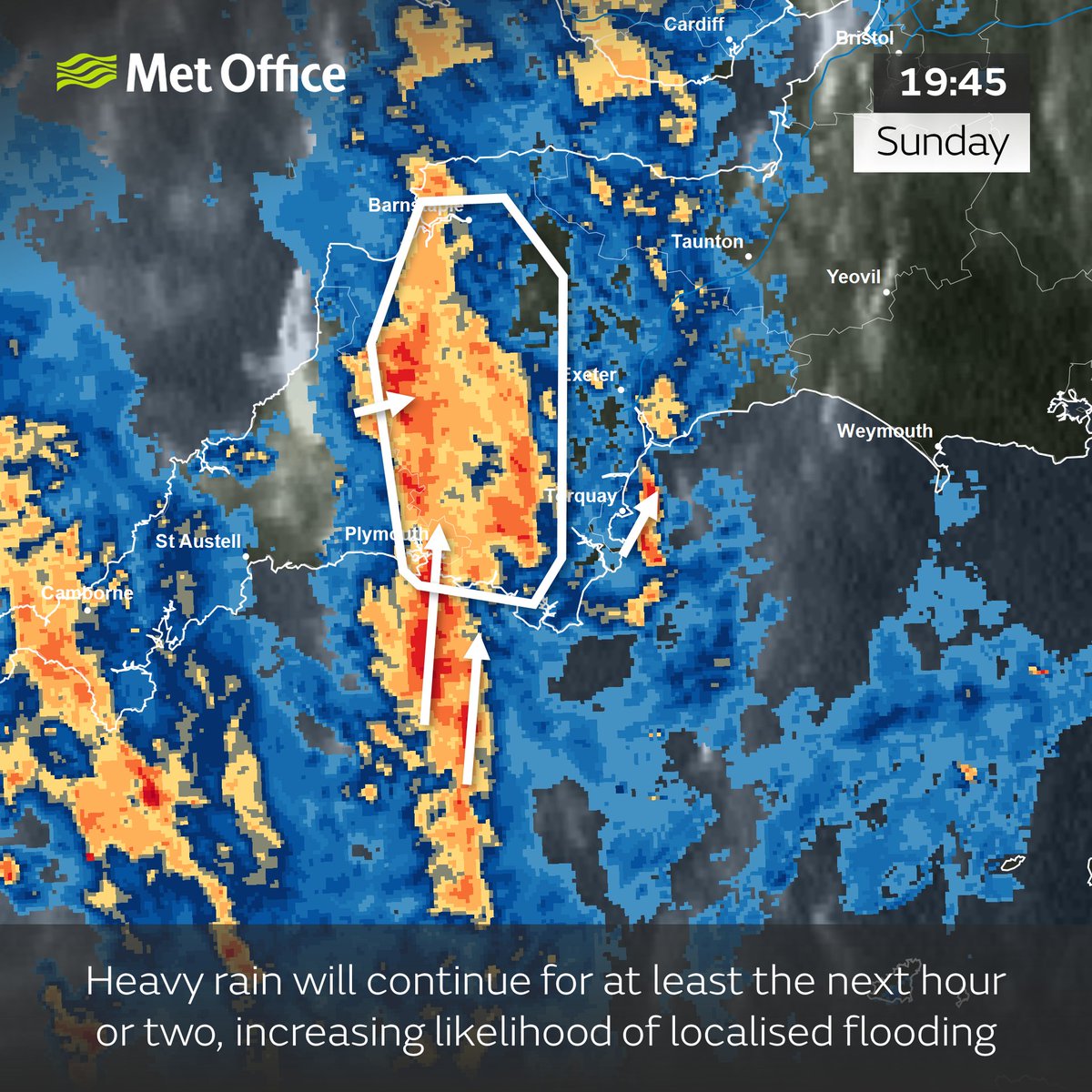
    Heavy rain ⛈️ will continue to feed in from the south, affecting the highlighted area including Plymouth. Increasing risk of flooded roads and difficult driving conditions - yellow #thunderstorm warning ⚠️now in force bit.ly/WxWarning Stay #WeatherAware
    Image
  • user avatar
    Met Office - SW England
    @metofficeSWEng
    Aug 15, 2022
    Showers and #thunderstorms⛈️are expected to become more widespread over the next 2-3 hours; some locations experiencing torrential downpours, accompanied by lightning, and hail at times. A yellow thunderstorm warning is in force - bit.ly/WxWarning⚠️ Stay #WeatherAware
    Image
  • user avatar
    Met Office - SW England
    @metofficeSWEng
    Jan 1, 2025
    Yellow warning of snow affecting South West England metoffice.gov.uk/weather/warnin…
    Image
    23K
  • user avatar
    Met Office - SW England
    @metofficeSWEng
    Mar 1, 2018
    Red Warning of Wind and Snow for South West England dlvr.it/QJGxST
  • user avatar
    Met Office - SW England
    @metofficeSWEng
    Jan 21, 2024
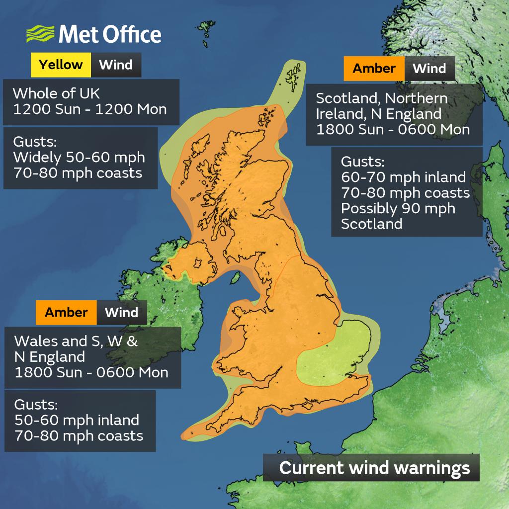
    #StormIsha now steaming across #SWEngland - keep #weatheraware due to wild and very windy outdoor conditions. Peak of the winds passes through during the early hours of Monday morning...but until then could see some travel disruption and power outages
    user avatar
    Met Office
    @metoffice
    Jan 21, 2024
    ⚠️ Weather warnings for #StormIsha have been updated ⚠️ Latest info 👉bit.ly/WxWarning Here are the latest details 👇
    A map showing the latest wind warnings in association with Storm Isha.

Amber warning for Scotland, Northern Ireland, and parts of northern England. Valid between 1800 Sunday to 0600 Monday. Gusts widely 60-70 mph with gusts of 70-80 mph along some coasts. Winds possibly reaching 80-90 mph in Scotland.

Amber warning for northern and central England, Wales, and southern and western England. Valid between 1800 Sunday and 0600 Monday. Gusts widely 50-60 mph with gusts of 70-80 mph along some coasts.

Yellow warning across the whole of the UK valid between 1200 Sunday and 1200 Monday. Gusts widely 50-60 mph and reaching 60-70mph in exposure.
    A map showing the latest rain warnings in association with Storm Isha.

A yellow warning for parts of Scotland. Valid 1500 to 2359 Sunday. 30-50 mm of rain across high ground, combined with snow melt.

A yellow warning for parts of northwest England. valid 0000 Sunday to 0600 Monday. Widely 30-50 mm of rain with 80-100 mm over hills. This will be combined with snow melt.

A yellow warning for parts of Wales. Valid 0000 Sunday to 0600 Monday. Widely 20-50 mm of rain with 80-100 mm over hills. This will be combined with snow melt.
    31K
  • user avatar
    Met Office - SW England
    @metofficeSWEng
    May 15, 2022
    ⛈️ Thunderstorms will bring heavy rain, lightning and hail in places, particularly in parts of Dorset, Hampshire and the Isle of Wight over the next 2-3 hours ⚠️A yellow #thunderstorm warning remains in force bit.ly/WxWarning Stay #WeatherAware
    Image
  • user avatar
    Met Office - SW England
    @metofficeSWEng
    Jul 19, 2022
    🌩️ Thunderstorms with frequent lightning and very localised heavy rain will affect southwest Cornwall and Isles of Scilly over the next couple of hours before becoming more isolated by mid-morning Stay #WeatherAware
    Image
  • user avatar
    Met Office - SW England
    @metofficeSWEng
    Jul 11, 2022
    Amber warning of extreme heat affecting South West England metoffice.gov.uk/weather/warnin…
    Image
  • user avatar
    Met Office - SW England
    @metofficeSWEng
    Jul 15, 2022
    Red warning of extreme heat affecting South West England metoffice.gov.uk/weather/warnin…
    Image
  • user avatar
    Met Office - SW England
    @metofficeSWEng
    Aug 16, 2022
    ⛈️ A developing line of thunderstorms is moving slowly northwest out of Dorset into parts of Devon and Somerset ⚠️ A yellow #thunderstorm warning is in force with localised flooding and travel disruption probable bit.ly/WxWarning Stay #WeatherAware
    Image

New to X?

Sign up now to get your own personalized timeline!

Create account

By signing up, you agree to the Terms of Service and Privacy Policy, including Cookie Use.

Terms of Service|Privacy Policy|Cookie Policy|Accessibility|Ads info|© 2026 X Corp.
Don't miss what's happening
People on X are the first to know.
Log inSign up
Advertisement
Advertisement