
Hackaday Links Column Banner

Hackaday Links: October 17, 2026

While Hackaday doesn’t maintain a crime blotter, we couldn’t help but start this week’s post off with a bit of civil disobedience — a retired professor from the University of Pennsylvania was arrested earlier this week for standing in front of a delivery robot.

Granted, she was standing there for long enough that the police were eventually called, but still. Previous reporting indicates that Carolyn Marvin has a history of blocking delivery robots as a form of protest, but this is the first time law enforcement got involved. We’re not lawyers here at Hackaday, so we can’t say for sure whether or not blocking the progress of a robot engaged in commercial operation actually violates any laws. But we do know that refusing a lawful request from a police officer will get you in trouble, and that seems to be what Marvin was actually charged with when she refused to move.
Continue reading “Hackaday Links: October 17, 2026” →

Image

Tracking Planes With An ESP8266

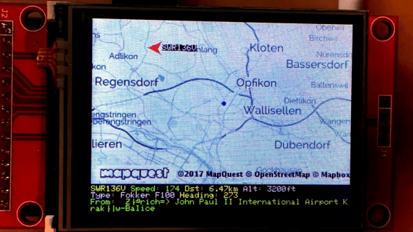
While there are apps that will display plane locations, [squix] wanted to build a dedicated device for plane spotting. The ESP8266 PlaneSpotter Color is a standalone device that displays a live map with plane data on a color TFT screen. This device expands on his PlaneSpotter project, adding a color display and mapping functions.

First up, the device needs to know where planes are. The ADS-B data that is transmitted from planes contains useful data including altitude, velocity, position, and an identifier unique to the aircraft. While commercial services exist for getting this data, the PlaneSpotter uses ADS-B Exchange. You can set up a Raspberry Pi to record this data, and provide it to ADS-B Exchange.

With the plane data being received from the ADS-B Exchange API, it’s time to draw to the screen. The JPEGDecoder fork for ESP8266 is used for drawing images, which are fetched from the MapQuest API as JPEGs.

Finally, geolocation is needed to determine where in the world the PlaneSpotter is. Rather than adding a GPS module, [squix] went with a cheap solution: WiFi geolocation. This uses identifying information and signal strengths from nearby WiFi access points to determine location. This project uses a public API by [Alexander Mylnikov], which returns a JSON object with longitude and latitude.

This project demonstrates what the ESP8266 is capable of, and brings together some neat techniques. If you’re looking to geolocate or display maps on an ESP8266, the code is available on Github.

Continue reading “Tracking Planes With An ESP8266” →

Map Abstraction API In Javascript

Image
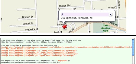
Maybe you’ve tinkered a bit with the Google Maps API. Most of the software produced with it is not all that useful or entertaining, but a few gem have shone through. Still, wouldn’t it be better if applications produced with it could be easily ported to other online mapping services like Mapquest or Yahoo! Maps?

This is possible with Mapstraction, a Javascript API that works with nine mapping services and plans to incorporate more into the fold. Mapstraction has open-source features that normalize functions across the biggest services, which makes searching for map data a consistent, predictable experience no matter which service you use.

Some of Mapstraction’s current features are what you would expect: point, line, and polygon support, image overlay, GeoRSS and KML feed importing, and several others. We’re really looking forward to future versions with OpenStreetMap support. Currently Mapstraction works with only commercial mapping services, but OpenStreetMap combined with Mapstraction directly hits the sweet spot; a customizable, open source map.

[via Hackszine]