[syndicated profile] earthobservatory_iod_feed

Posted by Lauren Dauphin

Image Image
November 26, 2025
December 8, 2025
False-color radar images show more rough terrain (green) in the St. Elias Mountains near Hubbard Glacier after an earthquake on December 6, 2025, indicating landslides and avalanches.
NASA Earth Observatory / Lauren Dauphin
False-color radar images show more rough terrain (green) in the St. Elias Mountains near Hubbard Glacier after an earthquake on December 6, 2025, indicating landslides and avalanches.
NASA Earth Observatory / Lauren Dauphin
False-color radar images show more rough terrain (green) in the St. Elias Mountains near Hubbard Glacier after an earthquake on December 6, 2025, indicating landslides and avalanches.
NASA Earth Observatory / Lauren Dauphin
False-color radar images show more rough terrain (green) in the St. Elias Mountains near Hubbard Glacier after an earthquake on December 6, 2025, indicating landslides and avalanches.
NASA Earth Observatory / Lauren Dauphin
November 26, 2025
December 8, 2025

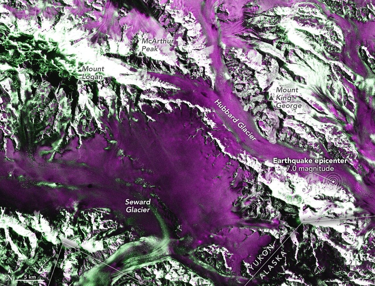
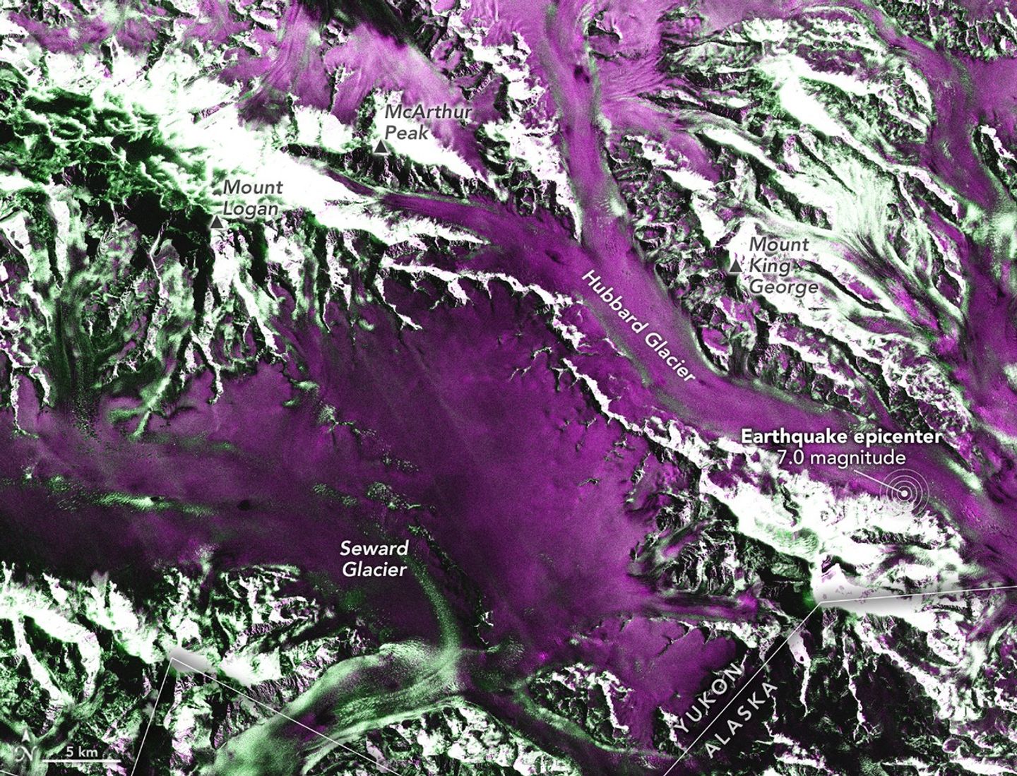
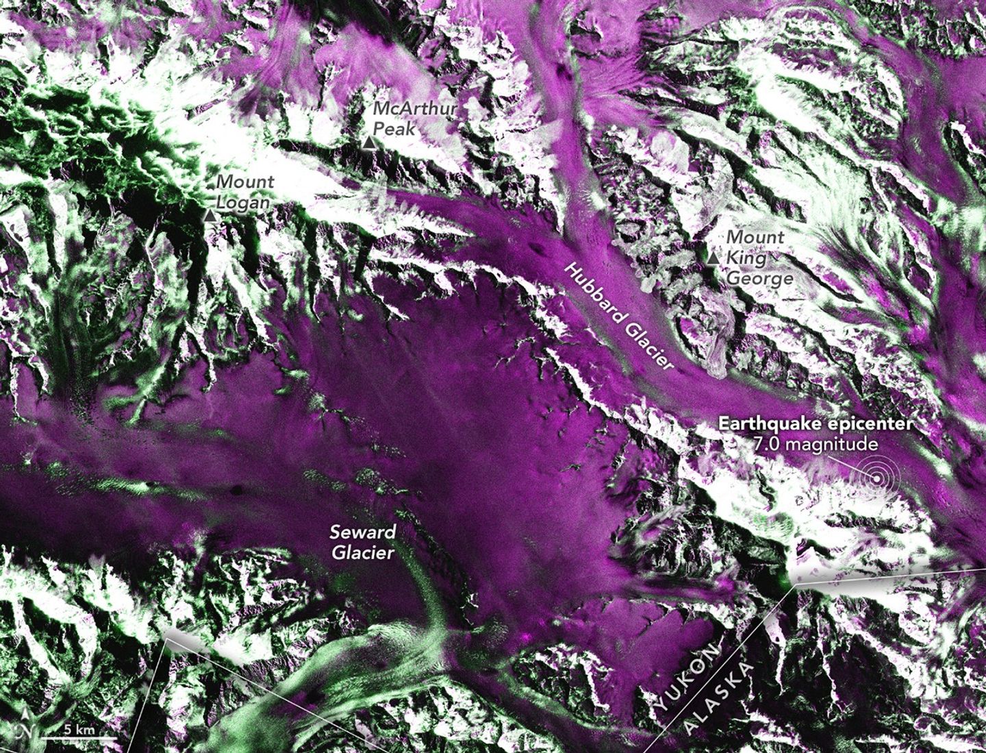
On December 6, 2025, a powerful magnitude 7.0 earthquake struck the remote St. Elias Mountains, a highly glaciated range that spans the Yukon-Alaska border. The quake shook the landscape beneath Hubbard Glacier, sending ice and rock careening down the range’s steep slopes. The NISAR (NASA-ISRO Synthetic Aperture Radar) satellite offered some of the earliest views of the changed landscape.

Geophysicist Eric Fielding and colleagues at NASA’s Jet Propulsion Laboratory (JPL) typically use satellite data to map the displacement of the ground after major earthquakes strike land. But in this region, such maps—known as interferograms—are not possible because the ground lies buried beneath a layer of glacial ice that’s at least 700 meters (2,000 feet) thick. “The cryosphere is covering up the geosphere,” Fielding said.

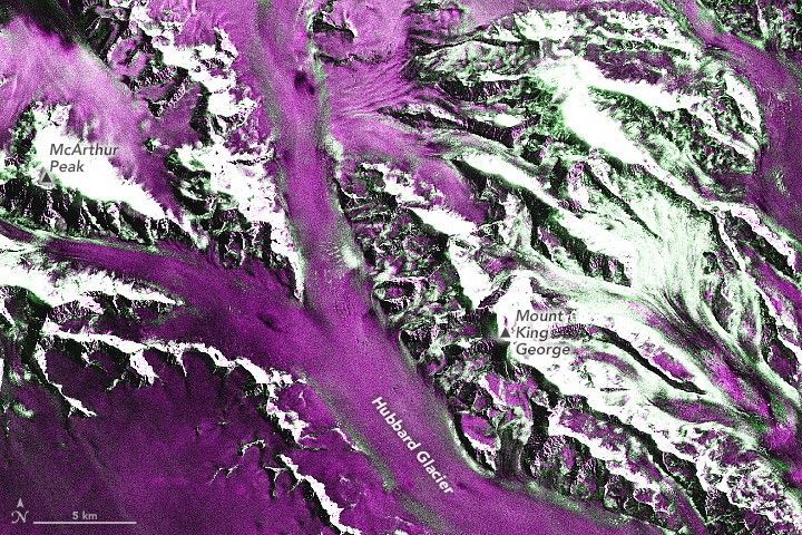
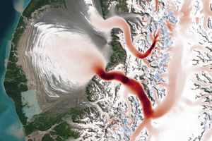
Instead, clues to the earthquake’s destructive power lay strewn atop the ice surface. The shaking on December 6 unleashed landslides and avalanches that swept debris onto lower, flatter stretches of the glacier. The debris is visible in radar imagery acquired by NISAR on December 8, two days after the quake (right). For comparison, the NISAR image on the left shows the same area on November 26, a week and a half before the quake.

Where the slides have deposited rock, snow, and other debris, surfaces have become rougher, which scatters more energy back toward the sensor and makes those areas appear bright in the December 8 image (the roughest areas are shown in dark green). Areas with smooth surfaces reflect little of the radar’s energy directly back to the satellite sensor, so these parts of the images appear dark (shown in purple). Note that there are some exceptionally rough, green surfaces beyond the new slide areas that remain relatively unchanged between the two images.

Image Image
November 26, 2025
December 8, 2025
False-color radar images show a detailed view of the area around Mount King George and McArthur Peak, where most of the landslides and avalanches were visible following an earthquake on December 6, 2025.
NASA Earth Observatory / Lauren Dauphin
False-color radar images show a detailed view of the area around Mount King George and McArthur Peak, where most of the landslides and avalanches were visible following an earthquake on December 6, 2025.
NASA Earth Observatory / Lauren Dauphin
False-color radar images show a detailed view of the area around Mount King George and McArthur Peak, where most of the landslides and avalanches were visible following an earthquake on December 6, 2025.
NASA Earth Observatory / Lauren Dauphin
False-color radar images show a detailed view of the area around Mount King George and McArthur Peak, where most of the landslides and avalanches were visible following an earthquake on December 6, 2025.
NASA Earth Observatory / Lauren Dauphin
November 26, 2025
December 8, 2025

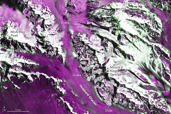
The largest slide in the scene appears to be cascading down the flank of Mount King George, but it’s far from the only one. Numerous others scar the surrounding terrain, including areas to the west along the slopes of Mount Logan, Canada’s tallest mountain.

Alex Gardner, a glaciologist at JPL and member of the NISAR science team, reviewed the images with Fielding. “The sheer number and magnitude of avalanches and landslides is astounding,” Gardner said. “I’ve personally never seen anything like this before.”

A separate preliminary analysis by the U.S. Geological Survey identified more than 700 potential landslides and snow avalanches, with an especially high concentration northwest of the epicenter along the fault rupture. Follow-up flights by the Yukon Geological Survey on December 12 provided a closer look, showing some slopes remained actively unstable, with dust still hanging in the air, and widespread damage to glacial ice.

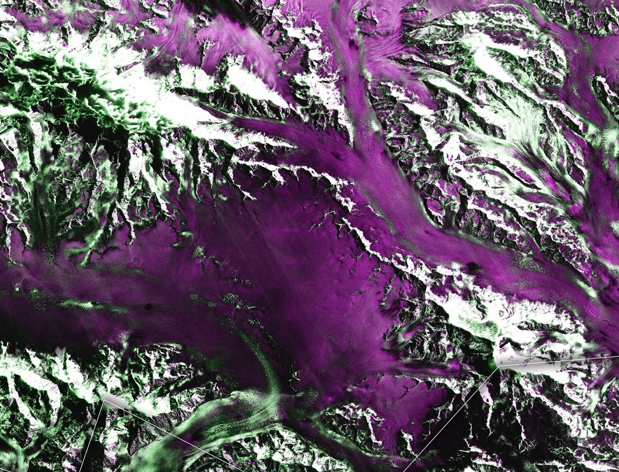
Much of the debris that settled atop the region’s glacial ice is likely being transported toward the ocean by the glaciers’ ongoing seaward flow, which acts as a natural “conveyor belt.” For example, a tributary glacier of Hubbard north of Mount King George, which had previously moved at a sluggish pace, entered a surging phase in November before the earthquake. It is now moving downslope at what Gardner described as “breakneck speeds” of up to 6,000 meters per year (about 50 feet per day).

Although the region is uninhabited, the slides and damaged ice could pose new hazards for mountaineers and other expeditions, USGS noted in a December 18 update. The town of Yakutat, Alaska, about 90 kilometers (56 miles) south of the epicenter, is a common staging point for people exploring the area.

NISAR observations are expected to provide imagery to support future natural disaster response efforts.

Images by Gustavo Shiroma (JPL) of the NISAR Algorithm Development Team using data from the NISAR GSLC product, and prepared for NASA Earth Observatory by Lauren Dauphin. Story by Kathryn Hansen.

References & Resources

You may also be interested in:

Stay up-to-date with the latest content from NASA as we explore the universe and discover more about our home planet.

Image
Mapping Kamchatka Earthquake Displacement
7 min read

A group of satellites with interferometric synthetic aperture radar makes it possible for geologists to detect how much and where…

Article
Image
Alaska’s Brand New Island
3 min read

A landmass that was once encased in the ice of the Alsek Glacier is now surrounded by water.

Article
Image
Satellites Detect Seasonal Pulses in Earth’s Glaciers
4 min read

From Alaska’s Saint Elias Mountains to Pakistan’s Karakoram, glaciers speed up and slow down with the seasons.

Article

The post Landslide and Avalanche Debris Litter Hubbard Glacier appeared first on NASA Science.

Testing, Testing

Feb. 24th, 2026 06:47 pm
billroper: (Default)
[personal profile] billroper
Today was spent writing unit tests and fixing bugs that turned up when I ran the unit tests.

Which is, I suppose, the best reason for writing unit tests.

I have a few more unit tests to write tomorrow and then I can move on to the next project.

Showy Swirls Around Jeju Island

Feb. 24th, 2026 05:01 am
[syndicated profile] earthobservatory_iod_feed

Posted by Michala Garrison

A series of spiraling clouds extends southeast from an oval-shaped island in the Korea Strait. To the west, a large sediment plume fans out from the coast of China and forms tan, teal, and blue swirls in the water.
February 19, 2026

The tallest point in South Korea is not located in the Taebaek Mountains that run along the country’s eastern coast. Rather, it is found atop a volcanic peak on Jeju Island, about 100 kilometers (60 miles) south of the Korean Peninsula. In winter 2026, winds blew past the island in just the right way to send clouds spinning in its wake.

The MODIS (Moderate Resolution Imaging Spectroradiometer) on NASA’s Terra satellite captured this image of swirling clouds—and colorful, turbulent water—near Jeju Island on February 19, 2026. The island rises about 1,950 meters (6,400 feet) above the sea surface. At its center is Hallasan, a shield volcano that last erupted in the 11th century and contains a notable network of lava tubes.

The trailing, staggered spirals, called von Kármán vortex streets, form when a fluid passes a tall, isolated, stationary object. If winds are too weak, clouds simply flow smoothly past, and if winds are too strong, vortices cannot maintain their shape. In the sweet spot, with winds between 18 and 54 kilometers (11 and 34 miles) per hour, clouds trace the airflow in patterns of counterrotating vortices. Though the underlying physics is the same, the appearance of the vortices can vary: sometimes they look wispy, as they do here, and other times they form more sharply defined, parallel rows, as they did at the same location the previous day.

The seas, as well as the atmosphere, were turbulent near Jeju Island in mid-February. To the west, a large plume of sediment coming off the coast of China’s Jiangsu province turned waters murky. While brown, sediment-laden water is present in the shallow nearshore area year-round, expansive plumes like this one are common during winter. Research suggests that seasonal changes in currents and vertical mixing of the water column may account for the large winter plumes.

NASA Earth Observatory image by Michala Garrison, using MODIS data from NASA EOSDIS LANCE and GIBS/Worldview. Story by Lindsey Doermann.

References & Resources

You may also be interested in:

Stay up-to-date with the latest content from NASA as we explore the universe and discover more about our home planet.

Image
Islands of Fire and Ice Veiled in Cloud
3 min read

Puffs of low-level clouds mingle with the volcanic terrain of Candlemas and Vindication islands in the remote South Atlantic.

Article
Image
A Plume of Bright Blue in Melissa’s Wake
5 min read

The category 5 hurricane stirred up carbonate sediment near Jamaica in what scientists believe is the largest such event in…

Article
Image
Puerto Rico From Above
4 min read

An astronaut photographed the island’s striking mix of mountains, forests, and expanding urban areas.

Article

The post Showy Swirls Around Jeju Island appeared first on NASA Science.

Back to Work

Feb. 23rd, 2026 09:19 pm
billroper: (Default)
[personal profile] billroper
It was back to work today. I think I've gotten a bit of coding done, but we'll see what happens when I finish writing the unit tests *and* the guys who are supposed to hook it up to the UI take a run at it.

In other news, I was pinged by one of my fellow programmers today who was playing around with the OLE compound document format that our desktop files are stored in. I showed him the set of Java code that I wrote on top of Apache POI to provide additional support for features that we're using. Then I said, "Watch this."

I bounced into VS Code and fired up Cline and told it to look at these classes in my source base and then write a code snippet that would open up a desktop file and dump out all of the custom settings from the user defined property set. Now this isn't overly hard code to write, but even so, the resulting code was very nice and took advantage of features like try-with-resources and such. I cut the code out and emailed it to my coworker, suggesting that he could put this somewhere that we could get at it. :)

It was, in any case, faster than writing it myself and certainly not bad code.

On a completely different note, if no one is interested in the treadmill, I am going to list it sometime in the next few days as available for free on Nextdoor, which is a pretty good way to get large objects to leave my home. If you *are* interested, let me know.
[syndicated profile] earthobservatory_iod_feed

Posted by Rafael Alanis

2 Min Read

Curiosity Studies Nodules on Boxwork Formations

These bumpy nodules were formed by minerals left behind as groundwater was drying out on Mars billions of years ago. NASA’s Curiosity rover captured images of these pea-size features while exploring geologic formations called boxwork on Aug. 21, 2025.
PIA26697
Credits: NASA/JPL-Caltech/MSSS

Description

NASA’s Curiosity Mars rover discovered these bumpy, pea-sized nodules while exploring a region filled with boxwork formations — low ridges standing roughly 3 to 6 feet (1 to 2 meters) tall with sandy hollows in-between. This mosaic is made up of 50 individual images taken by Curiosity’s Mars Hand Lens Imager (MAHLI), a camera on the end of the rover’s robotic arm, on Aug. 21, 2025, the 4,636th Martian day, or sol, of the mission. Ten images at different focus settings were taken at each of five locations to produce a sharp mosaic. The images were stitched together after being sent back to Earth.

Figure A is the PIA26697 image with a small scale bar added to the right-hand side.
Figure A

Figure A is the same image with a small scale bar added to the right-hand side.

Nodules like these have been seen many times before on the Red Planet, including by Curiosity. They were made by minerals left behind as water dried billions of years ago. Crisscrossing the surface for miles, the boxwork formations suggest ancient groundwater flowed on this part of the Red Planet later than expected, raising new questions about how long microbial life could have survived on Mars billions of years ago, before rivers and lakes dried up.

The boxwork ridgetops often include a dark line the team refers to as “central fractures,” where groundwater originally seeped through a rock crack, allowing minerals to concentrate. Surprisingly, the mission did not find nodules near these central fractures. Instead, they were found along the walls of the ridges and in the hollows between them. The wavy ridges between the groups of nodules are mineral veins made of calcium sulfate, also deposited by groundwater.

Curiosity was built by NASA’s Jet Propulsion Laboratory, which is managed by Caltech in Pasadena, California. JPL leads the mission on behalf of NASA’s Science Mission Directorate in Washington as part of NASA’s Mars Exploration Program portfolio. MAHLI was built by Malin Space Science Systems in San Diego.

To learn more about Curiosity, visit:

science.nasa.gov/mission/msl-curiosity

The post Curiosity Studies Nodules on Boxwork Formations appeared first on NASA Science.

Curiosity Surveys the Boxwork Region

Feb. 23rd, 2026 05:34 pm
[syndicated profile] earthobservatory_iod_feed

Posted by Rafael Alanis

1 Min Read

Curiosity Surveys the Boxwork Region

NASA’s Curiosity Mars rover captured this panorama of boxwork formations — the low ridges seen here with hollows in between them — using its Mastcam on Sept. 26, 2025.
PIA26693
Credits: NASA/JPL-Caltech/MSSS

Description

NASA’s Curiosity Mars rover captured this panorama of boxwork formations — the low ridges seen here with hollows in between them — using its Mastcam on Sept. 26, 2025, the 4,671st Martian day, or sol, of the mission. These boxwork formations were created billions of years ago when water leaked through rock cracks. Minerals carried into the cracks later hardened; after eons of windblown sand eroding away the softer rock, the hardened ridges were left exposed.

The panorama is made up of 179 individual images that were stitched together after being sent back to Earth. This natural color view is approximately how the scene would appear to an average person if they were on Mars. 

Curiosity was built by NASA’s Jet Propulsion Laboratory, which is managed by Caltech in Pasadena, California. JPL leads the mission on behalf of NASA’s Science Mission Directorate in Washington as part of NASA’s Mars Exploration Program portfolio. Malin Space Science Systems in San Diego built and operates Mastcam.

For more about Curiosity, visit:

science.nasa.gov/mission/msl-curiosity

The post Curiosity Surveys the Boxwork Region appeared first on NASA Science.

[syndicated profile] earthobservatory_iod_feed

Posted by Michala Garrison

Image Image
January 24, 2026
February 3, 2026
Gulf waters off southwestern Florida appear dark blue, except for some lighter greenish areas along the coast and Florida Keys.
NASA Earth Observatory
Gulf waters off southwestern Florida appear bright blue due to suspended sediment. The water swirls into intricate patterns along the bright area’s western edge as it transitions to dark blue.
NASA Earth Observatory
January 24, 2026
February 3, 2026

In late January and early February 2026, surges of Arctic air funneled into eastern North America, causing cold and wintry conditions across much of the United States. Snow and ice blanketed large swaths of the country, stretching as far south as Georgia, in a layer of white. Meanwhile, waters off the west coast of Florida lit up in brilliant shades of blue.

In this rare outbreak of intense winter weather, cold air infiltrated Florida and drove temperatures below freezing in several counties at the start of February. This frigid intrusion not only caused beautiful phenomena in the atmosphere, forming cloud streets, but it also produced a colorful display in the shallow marine waters below, stirring up carbonate sediment from the seafloor.

On February 3, the MODIS (Moderate Resolution Imaging Spectroradiometer) on NASA’s Terra satellite captured this image (right) of brightened waters over the West Florida Shelf, a broad and shallow continental shelf region known as a carbonate ramp. The blue color comes from suspended calcium carbonate (CaCO3) mud, which consists primarily of remnants of marine organisms that live on the shelf. For comparison, the left image shows the area on January 24, before the cold air arrived.

The mud was mostly kicked up by wind-stirred ocean waters during the cold air event, said James Acker, a data support scientist at the NASA Goddard Earth Sciences Data and Information Services Center. Sediment suspension events like this are more typically associated with hurricane winds that churn the water, as with Melissa in 2025, but the winds brought by strong cold fronts can have a similar, if less dramatic, effect.

“Another interesting aspect of these events is that the cold air cools off the shallow water on the banks and makes it denser than the surrounding warmer open ocean water,” Acker said. When this dense water sinks and flows offshore with the tides, it can carry some of the sediment out toward the shelf’s edge.

The water north of the Florida Keys appears bright blue to white. To the south, it is dark blue except for a long, narrow bright band running from west to east.
February 3, 2026
An area of bright blue swirling water includes a feature with a hammerhead-like shape, with eddies curling off either side of a narrow jet.
February 3, 2026

The detailed images above, acquired with the OLI (Operational Land Imager) on Landsat 9, offer a closer look at that process playing out. “Hammerhead” eddy features appeared along the slope of the West Florida Shelf, Acker noted. These can form when narrow streams of denser chilled seawater carry sediment offshore, encounter slower-moving Gulf waters, and curl into pairs of counterrotating eddies, he said. These types of features have been observed in other natural events—dust storms, for example—both on Earth and on Mars.

Other dynamics were at work near the Dry Tortugas on the southwestern side of the shelf, where the patch of bright water ends abruptly along a straight, sharp edge. Here, sediment-laden water exited the shelf area through channels to the south, said sedimentologist Jude Wilber, and was immediately swept east by the Loop Current. After Hurricane Ian stirred up sediment off Florida in 2022, Wilber and Acker noted a similar interaction between suspended material and the Loop Current. The researchers used that event to improve satellite-based methods for estimating sediment concentrations in these plumes.

Scientists are interested in studying carbonate sediment suspension events because of their role in the planet’s carbon cycle. They have shown that tropical cyclones are the primary mechanism by which carbon in shallow-water marine sediments is moved to deeper waters, where it can remain sequestered for a long time. However, the contribution of cold fronts is less well understood. Acker and Wilber hypothesize that they act on a more local scale: they influence ocean color by stirring sediments but do not transport significant amounts of material to the deep ocean.

NASA Earth Observatory images by Michala Garrison, using MODIS data from NASA EOSDIS LANCE and GIBS/Worldview, and Landsat data from the U.S. Geological Survey. Story by Lindsey Doermann.

References & Resources

You may also be interested in:

Stay up-to-date with the latest content from NASA as we explore the universe and discover more about our home planet.

Image
A Plume of Bright Blue in Melissa’s Wake
5 min read

The category 5 hurricane stirred up carbonate sediment near Jamaica in what scientists believe is the largest such event in…

Article
Image
Extreme January Cold
3 min read

Following a significant winter storm, frigid temperatures lingered in late January 2026 across a vast swath of the U.S.

Article
Image
Rokan River Painted by the Tides
2 min read

Tides and sediment form brushstroke-like patterns across the river estuary in eastern Sumatra.

Article

The post Arctic Blast Brightened the West Florida Shelf appeared first on NASA Science.

Smaller Steps

Feb. 22nd, 2026 09:25 pm
billroper: (Default)
[personal profile] billroper
I spent some time today dealing with some smaller projects around the house. One of these was to take some measurements in the library, which is now done.

The next trick is going to be finding someone who wants our old Reebok RX-3000 treadmill which is sitting in the library taking up space. It is free to a good home. A good home is currently defined as "someone who is willing to take it away". :)

I am continuing my efforts to get the Flash pinball in the basement up and running. One of the projects that I may be able to handle myself is to fix some screw holes in the playfield where the screw no longer bites in properly, resulting in loose parts, which is not good. Filling these with toothpicks and wood glue has been suggested. Curiously, that is the same suggestion that has been made online for fixing Julie's bedroom door, which will not latch. I figured that I like the pinball machine better than the bedroom door, so why not experiment there?

The door still does not latch. It *might* latch if I had carved out a bit more wood to make room for the strike plate, because the door actually *does* latch if I *remove* the strike plate. But the toothpick and glue method is a bit messy.

I fixed one of our bathroom cabinets that had a similar problem using some very nice wood filler and I am thinking this may be a better solution to the problem. I will think about this a bit longer before taking a run at it. :)

Anyway, tomorrow it will be back to work, so projects will wait for a bit for me to catch up...

Done Since 2026-02-15

Feb. 22nd, 2026 05:16 pm
mdlbear: blue fractal bear with text "since 2002" (Default)
[personal profile] mdlbear

It's been a rather stressful week, and most of the time I've been very down on myself, mostly for procrastination. But I got through it. I think I'm supposed to count that as a win, even though it doesn't feel like it.

I did figure something out, though. I often (usually?) procrastinate things that may require a decision, because when I finally get around to them the decision often (usually?) turns out to be wrong. (The decision is sometimes to skip something with a time limit, and then regretting not going for it while I had the chance. Same thing.)

Now that Discord has started age-gating NSFW channels and servers, many people (including me) are looking for alternatives. Especially since it was revealed that their age verification vendor Persona left frontend exposed, researchers say. In particular, people are looking for open source alternatives, since those are less likely to be enshittified in the future. We have some time, because most fannish discord communities have few, if any, NSFW channels, and because moving a community is always an extremely lossy process (as those of us who left LJ for DW remember well) and not to be undertaken lightly.

It's concievable that matterbridge could help hold things togather. Not counting on it. I hate this timeline.

You should also replace links that use archive.today, which includes archive.ph et.al., which I have lots of links to. That's going to take a long time. See also Wikipedia blacklists Archive.today, starts removing 695,000 archive links.

Links: You can find Babylon 5 on YouTube HERE. OpenFactBook - Country Data & Statistics is the replacement for the CIA's recently-shut-down World Factbook.

Notes & links, as usual )

Doing Things

Feb. 21st, 2026 09:47 pm
billroper: (Default)
[personal profile] billroper
Now that the taxes are out of my hands, there were other things to do today. Happily, none of them was laundry.

I took a box of stuff to Goodwill over lunch, getting it out of the house. Then it was off to Sam's Club, where I restocked a great many items. I have been intending to hang the GAFilk quilt that Gretchen won in absentia out in the hallway for a while now and *that* is finally done. While getting that sorted out, I put away the old CPAP as a backup, which cleaned that mess out of the chair in the bedroom that it had shared with the quilt.

I am filing a warranty claim for our leaky iSense mattress. They requested photos of the stripped mattress and the platform that it sits on, so I got that done (with a bit of help from Julie to stand the mattress on end so I could easily get photos of the platform) and sent them off. We'll see what they have to say, but the answer should be "let us fix this now". If it is not, there is going to be a problem.

And I ran the next-to-last session for the computer division in our APBA league, so I just have one more to get to the end of the year. All of the adjustments are made for three of the four teams, so this should be pretty straightforward once the fourth manager reports in.

Meanwhile, Gretchen made a lovely pot of beef stew using the stew beef that I picked up at Sam's Club earlier in the day. And then we went back and watched the recording of the Olympic women's free skate, which was a lot of fun.

Now it is time to go put the bed back together. Happily, the mattress is sitting on the platform, not standing on end...

Waving Bye to March

Feb. 20th, 2026 10:44 pm
billroper: (Default)
[personal profile] billroper
Ok, it *wasn't* March, but weather around here was certainly like the end of March -- and a *temperate* end of March -- for several days in a row. I was able to go to my lighter coat, the sun was shining. It was gorgeous.

February has now reasserted itself with a cold and blustery wind. It seemed even colder just because it had so recently been relatively warm.

Overall, it made sitting at my desk and getting some programming done look really good. :)

Real spring will be here soon.
[syndicated profile] tim_harford_feed

Posted by Tim Harford

Who will be the first to sail non-stop around the world? In 1968, The Sunday Times announces a trophy and a cash prize for the winner, and the Golden Globe Race is on.  Leading the charge are Robin Knox-Johnston, an old-fashioned British patriot, and Bernard Moitessier, an enigmatic French philosopher. As monstrous seas and deadly gales close in, the difference between victory and disaster will come down to just one word.  

For ad-free listening, monthly bonus episodes, monthly behind-the-scenes conversations, our newsletter, and more, please consider joining the Cautionary Club.

[Apple] [Spotify] [Stitcher]

Further reading

Stewart Brand’s new book is Maintenance: Of Everything. Robin Knox-Johnston gives his account of his voyage in A World of My Own, and Bernard Moitessier tells his story in The Long Way. Our two scripts on the Golden Globe race also relied on the books A Race Too Far by Chris Eakin, and A Voyage For Madmen by Peter Nichols.

[syndicated profile] earthobservatory_iod_feed

Posted by Lauren Dauphin

Plumes of gray smoke drift east-northeast from several grass and brush fires in the Oklahoma Panhandle. To the north, tan clouds of wind-borne dust cover portions of Kansas.
February 17, 2026

High winds coupled with dry conditions fueled fast-spreading wildland fires in the U.S. southern Plains in winter 2026. On February 17, several large blazes broke out on the Oklahoma Panhandle and burned quickly through tens of thousands of acres of grasslands and shrublands. The winds also caused dust storms and low visibility throughout the wider region.

Smoke from multiple fires as well as wind-borne dust streamed across the Plains on the afternoon of February 17, when the MODIS (Moderate Resolution Imaging Spectroradiometer) on NASA’s Aqua satellite acquired this image. The Ranger Road fire, the largest of the group, started that day shortly after noon near Beaver, Oklahoma, and spread rapidly throughout the afternoon. By the evening, it had burned into Kansas and consumed an estimated 145,000 acres (58,700 hectares), the Oklahoma Forestry Service reported. Combined with other fires nearby, including the Stevens and Side Road fires near Tyrone, Oklahoma, more than 155,000 acres burned that day, the agency said.

The Ranger Road fire exhibited features of a “fast fire,” a particularly dangerous and destructive type of fire characterized by rapid spread. These blazes usually burn in grasslands and shrublands rather than forests, often occur in autumn and winter when fuels are dry, and are propelled by strong winds. Wind gusts up to 70 miles (110 kilometers) per hour were measured across the Oklahoma and Texas panhandles on February 17, the National Weather Service said.

The fires destroyed several structures, threatened farmland and livestock, and prompted evacuation orders for parts of western Oklahoma and southern Kansas, according to news reports. Oklahoma’s governor declared a disaster emergency for counties in the Panhandle.

Persistent winds and dry conditions led to further fire growth on February 18. The Ranger Road and Stevens fires approximately doubled in size that day, the Oklahoma Forestry Services reported. On February 19, a red flag warning remained in effect for the Texas and Oklahoma panhandles, with forecasts calling for wind gusts up to 40 miles (64 kilometers) per hour and very low relative humidity.

Wind-blown dust created other serious hazards across the region. Near Pueblo, Colorado (west of this scene), poor visibility led to a deadly pileup of dozens of vehicles on Interstate 25, according to reports. And in southern New Mexico, officials warned travelers of dangerous conditions due to blowing dust.

NASA Earth Observatory image by Lauren Dauphin, using MODIS data from NASA EOSDIS LANCE and GIBS/Worldview. Story by Lindsey Doermann.

References & Resources

You may also be interested in:

Stay up-to-date with the latest content from NASA as we explore the universe and discover more about our home planet.

Image
B.C. Wildfires Send Smoke Skyward
2 min read

Lightning likely ignited several large fires that sent smoke pouring over the Canadian province in early September 2025.

Article
Image
Fires on the Rise in the Far North
3 min read

Satellite-based maps show northern wildland fires becoming more frequent and widespread as temperatures rise and lightning reaches higher latitudes.

Article
Image
Fires Erupt in South-Central Chile 
2 min read

Tens of thousands of people fled to safety as blazes spread throughout the country’s Biobío and Ñuble regions.

Article

The post Winds Whip Up Fires and Dust on the Southern Plains appeared first on NASA Science.

Page generated Feb. 25th, 2026 07:51 am
Powered by Dreamwidth Studios