


Skip to content

NEWSLETTER

Get the latest news as it happens.
You will receive our newsletter once a month about upcoming events and webinars as well as latest news from the field.

Explore where NavVis shows up next

Join us at tradeshows, virtual sessions, and local events worldwide.
page-Industries-website-hero-2024

Industries

Whether you're a surveyor or reality capture specialist seeking accuracy and efficiency, an architect, engineer, or construction professional wanting to verify built results against your plans, an owner or operator needing updated spatial information, or a factory planner looking for the next optimization move, NavVis technology is here to help.
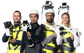
Laser scanning and point cloud management solutions for various industries

NavVis provides dynamic handheld reality capture devices and a comprehensive spatial data platform that helps teams generate accurate digital representations of physical spaces, integrate as-built data, and manage point clouds more efficiently.

With our wearable and handheld reality capture devices from NavVis CLX, NavVis MLX, NavVis VLX 3, and NavVis VLX 4 alongside our data processing, visualization, and collaboration platform, IVION, customers have an end-to-end reality capture solution for applications across surveying, engineering and construction, automotive, process manufacturing, and more. Capture sites at walking speed and manage your point clouds with intuitive tools for creation, collaboration, and publication.

Learn more about our use cases and how NavVis technology can help reduce project costs and improve collaboration across the project lifecycle.

1
Capture
navvis-lx-series-2026_new_700x450px

From small projects and confined spaces to large, complex environments, NavVis CLX, NavVis MLX, NavVis VLX 3, and NavVis VLX 4 give teams flexible tools for dynamic laser scanning indoors and outdoors.
NavVis LX-Series

2
Process
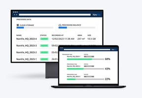
IVION-Processing-Mockup

With IVION Processing, you can process, geo-register and automatically align scan data with survey-grade accuracy. Objects moving through the scan are automatically detected and removed during post-processing.
IVION Processing

3
Collaborate
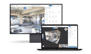
NavVis-IVION-Mockup-2026-1

IVION transforms point clouds and panoramic images into intelligent spaces accessible from any standard web browser, speeding up model creation and delivery, and adding value to your data.
IVION

4
Integrate
NavVis-IVION-Integrations-workflow-wp-industry-page

With IVION, achieve seamless integration and workflow compatibility. Gain access to a full range of downloadable data formats and the ability to export and import of points of interest with universally compatible file formats.

NavVis Partners

5

Or let NavVis manage all this for you if your company operates on an enterprise level.

Latest content and resources about laser scanning and its use cases

NavVisSep 21, 20265 min read

NavVis CLX Customer Perspective: Metrika360

Metrika360 is Germany’s leading specialist in 3D laser scanning and building digitization, delivering precise, fast, and ...
Start Reading
NavVisSep 21, 20265 min read

NavVis CLX Customer Perspective: EXACT (Precio Group)

EXACT is a comprehensive provider of high-quality survey technology services throughout Europe, specializing in capturing the ...
Start Reading
NavVisSep 14, 20263 min read

Introducing NavVis VLX 4: A Breakthrough in Dynamic Reality Capture, Delivering Exceptional Detail at Speed

Munich, September 14, 2026 – NavVis, the Source of Spatial Truth for the built world, introduces NavVis VLX 4, ushering in a ...
Start Reading
NavVisSep 1, 20264 min read

NavVis CLX Customer Perspective: Plowman Craven (Part 1)

Founded in 1964, Plowman Craven provides geospatial insight and surveying services that help customers shape assets that create ...
Start Reading
Press ReleaseSep 1, 20264 min read

NavVis Introduces CLX: The First Agile Handheld Capture Device for Reliable, Everyday Documentation at Scale

Munich, September 1, 2026: NavVis, the Source of Spatial Truth for the built world, is setting new standards for capturing and ...
Start Reading
NavVisSep 1, 20265 min read

NavVis CLX Customer Perspective: LE34

LE34 is Denmark’s largest provider of surveying and land management services. Across 31 offices in the Nordic region, its team ...
Start Reading
NavVisSep 1, 20264 min read

NavVis launches NavVis CLX, built for everyday documentation

NavVis today introduces NavVis CLX, an agile handheld capture device purpose-built for high-volume, everyday documentation. ...
Start Reading

Didn't find your industry or use case?

Don't hesitate to reach out!

Just fill out the form below, and one of our friendly representatives will get in touch with you soon.