1. X
  2. National Weather Service
Log inSign up
National Weather Service
46.7K posts
Image
user avatar
National Weather Service
@NWS
Official X account for @NOAA's National Weather Service. A list of official NWS accounts can be found at x.com/i/lists/725042…
United States
weather.gov
Joined January 2012
323
Following
3.1M
Followers
RepliesRepliesMediaMedia

Log in or sign up for X

See what’s happening and join the conversation

Continue with phone
or
Log in with username or email
Terms·Privacy·Cookies·Accessibility·Ads Info·© 2026 X Corp.
  • user avatar
    National Weather Service
    @NWS
    5h
    Strong winds and low humidity will produce critical to extremely critical fire weather conditions from the Northwest into the northern Rockies on Saturday and Sunday. Extremely dry fuels and erratic fire behavior have already been observed in this area, so there is concern for
    NOAA Storm Prediction Center Fire Weather Outlook for Saturday, August 1, 2026, valid through 7:00 AM Sunday, August 2. An Extremely Critical fire weather area (magenta with hatching) is centered near Spokane, Washington, surrounded by a broader Critical area (red) covering parts of eastern Washington, northeastern Oregon, and the Idaho Panhandle. An Elevated fire weather area (orange) extends across much of Idaho, western Montana, northeastern Nevada, southeastern Oregon, and portions of northern California. The map highlights the Inland Northwest as the primary area of concern for rapid wildfire growth due to a combination of strong winds, low humidity, and dry fuels.
    19K
  • user avatar
    National Weather Service
    @NWS
    9h
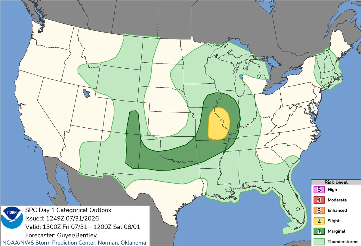
    Severe thunderstorms are possible this afternoon and evening across the middle Mississippi Valley and Ozarks. Isolated severe storms may also occur across the southern Plains and central/southern High Plains this afternoon through early evening. Visit weather.gov for
    NOAA Storm Prediction Center Day 1 Severe Weather Outlook for Friday, July 31, 2026, valid from 7:00 AM Friday through 7:00 AM Saturday. A Slight Risk (Level 2 of 5) area (yellow) is centered over eastern Missouri and western Illinois. A surrounding Marginal Risk (Level 1 of 5) area (dark green) extends from eastern New Mexico and west Texas across Oklahoma, Kansas, Missouri, Illinois, and into southern Wisconsin, with a separate marginal area over western Colorado. Broader light green thunderstorm areas cover portions of the central Rockies, central and southern Plains, Upper Midwest, Great Lakes, Gulf Coast, Florida, and New England, with a small area along the Georgia and South Carolina coast.
    44K
  • user avatar
    National Weather Service
    @NWS
    12h
    Take a deep breath—safely. 💨 Poor air quality can turn a fun outing into a health risk. If the air is unhealthy, limit the time you spend outside, wear a mask or move indoors. Check weather.gov for Air Quality alerts or AirNow.gov for the Air Quality
    Air Quality Safety during outdoor events: Poor air quality can put your health at risk during concerts, fairs, festivals, and sporting events. Planning ahead can keep you safe. Check the Air Quality Index (AQI) at AirNow.gov. AQI over 100 can impact sensitive groups. Over 150 is unhealthy for everyone. Limit outdoor activities in poor air quality. If feeling unwell, move indoors to air conditioning. Properly-fitting N95 masks can help protect you from poor air quality.
    21K
  • user avatar
    National Weather Service
    @NWS
    Jul 30
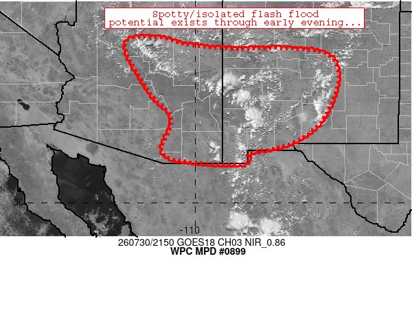
    Isolated flash flooding cannot be ruled out across Arizona and New Mexico this afternoon and evening.
    user avatar
    NWS Weather Prediction Center
    @NWSWPC
    Jul 30
    #WPC_MD 0899 affecting portions of Arizona and New Mexico, #nmwx #azwx, wpc.ncep.noaa.gov/metwatch/metwa…
    Image
    47K
  • user avatar
    National Weather Service
    @NWS
    Jul 30
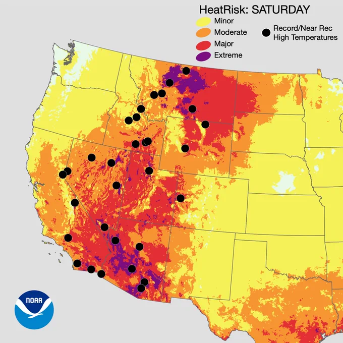
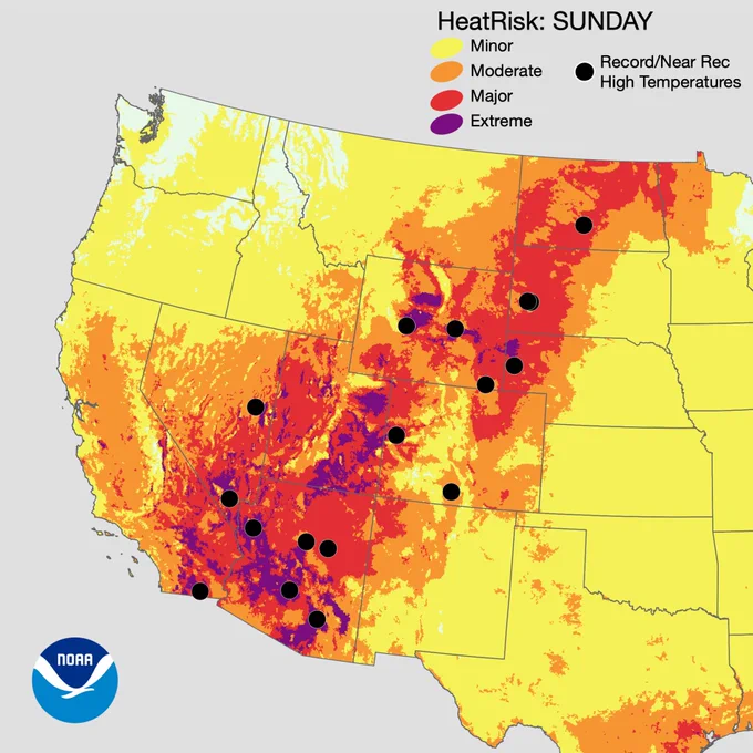
    Yes. It's summer, it's hot. However, what's in store for the southwest and Inter-mountain West into the weekend will be record highs during the hottest time of the year–dangerous for anyone that's unprepared while outdoors. Plan accordingly. weather.gov/heat
    NOAA HeatRisk map for Saturday across the western United States. Extreme HeatRisk (purple) is concentrated across portions of central Idaho, the Sierra Nevada and interior California, southern Nevada, western and central Arizona, and parts of western Utah, indicating the highest level of heat impacts. Major HeatRisk (red) surrounds these areas across much of California, Nevada, Arizona, Utah, western Colorado, Wyoming, and Montana. Moderate HeatRisk (orange) extends across much of the Interior West, while Minor HeatRisk (yellow) reaches into the Pacific Northwest, Great Basin, northern Rockies, and central High Plains. Black dots mark locations forecast to experience record or near-record high temperatures, scattered from southern California and Arizona north through Nevada, Utah, Idaho, Montana, Wyoming, and Colorado.
    NOAA HeatRisk map for Sunday across the western United States. Extreme HeatRisk (purple) remains focused across portions of southern California, southern Nevada, western and central Arizona, western Utah, and parts of western Colorado and central Idaho. Major HeatRisk (red) expands across much of California, Nevada, Arizona, Utah, western Colorado, Wyoming, and eastern Montana, while Moderate HeatRisk (orange) covers surrounding portions of the Great Basin, northern Rockies, and Southwest. Minor HeatRisk (yellow) extends across much of the Pacific Northwest, northern Rockies, central High Plains, and into west Texas. Black dots indicate record or near-record high temperatures, with forecast locations concentrated across California, Arizona, Utah, Colorado, Wyoming, and Montana.
    Stay indoors during heat waves. Stay indoors in air conditioning whenever possible. If your home doesn't have AC, check if your area has a cooling center. Remain hydrated by drinking water and avoiding alcohol. Check on those most vulnerable to heat, including children and the elderly. If you must go outdoors, go early or late in the day, and dress in light-colored clothing.
    97K
  • See @NWS's full profile

    Sign up
    Log in
Advertisement
Advertisement