
GROUND SETUP KIT FOR DRONE MAPPING
WingtraGROUND
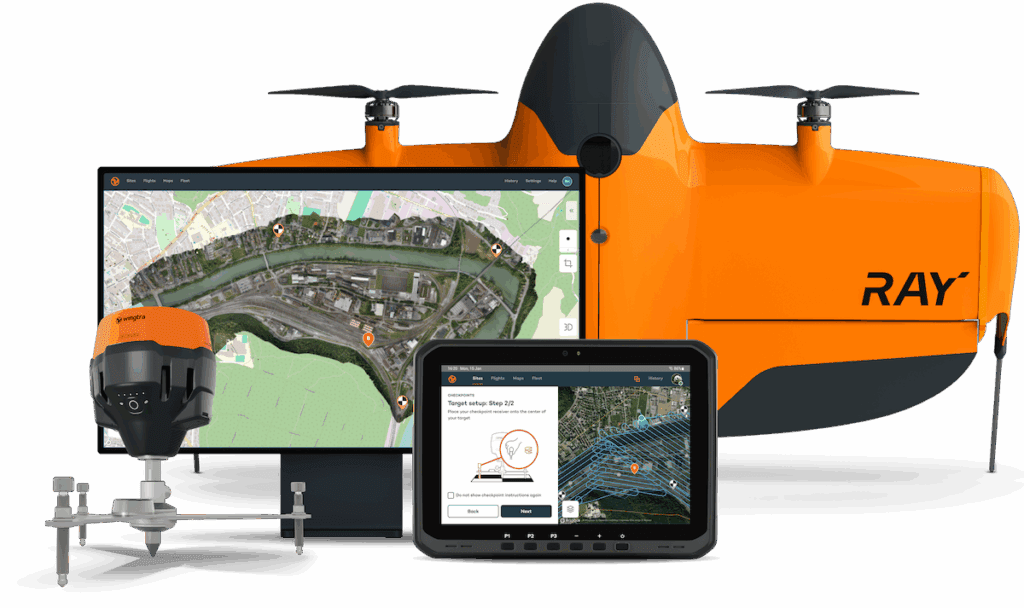
WingtraGROUND simplifies base station and checkpoint setup with an all-in-one portable solution, letting you deliver high quality survey data faster—without the usual hassle.
WingtraGROUND fully integrates into the Wingtra ecosystem, simplifying drone mapping and ensuring reliable accuracy.
Get the data you need faster and more reliably, so you can focus on delivering more projects.

Focus on the workflow
All-in-one kit
Integrated and pre-configured
Step-by-step guidance
Automatic data sync
Deliver accurate data with more confidence
Less error-prone steps
Confirmed placement of integrated receivers ensures reliable data capture, while checkpoints verify final deliverable accuracy of 3 cm (0.1 ft)*.
Easily adopt drone mapping
Verify your accuracy
Speed up data delivery
Get airborne faster
No more errors and backtracking
Get survey-quality data yourself

Focus on results, not the process
All-in-one kit
Simplified setup and workflow
Step-by-step guidance
Confidently collect accurate survey data
Automatic data upload
Error-free process
High precision
Achieve accuracy of 3 cm (0.1 ft)* without the need for specialized expertise.
Make better decisions faster
Immediate results
Minimal learning curve
End-to-end workflow
Discover WingtraGROUND’s improved workflow
Bulky equipment, hard for one person
Portable kit, one-person job
Fragmented, time-consuming setup
Quick setup in one system
Complicated setup, prone to human error
Error-free process, professional results
Place flexible targets and the receiver, and the app confirms the correct placement of checkpoints. Checkpoints then verify that your final deliverables achieve 3 cm (0.1 ft)* accuracy.
File handling and coordinate transformation
Automatic uploads, no errors
Error-prone manual inputs
Reliable accuracy, with less efforts
Why experts choose WingtraGROUND

Capturing approximately seven sites daily, my biggest challenges were connecting multiple devices and manually downloading and organizing files, WingtraGROUND has been a game-changer by automatically syncing data, saving me significant time and eliminating numerous manual steps.

We saved almost 50% of the time compared to our usual workflow, thanks to WingtraGROUND’s automatic file uploads, which eliminated manual tasks like file transfers, coordinate conversions, and geotagging. This significantly sped up checkpoint setup and map processing.
What’s in the kit
Everything you need for surveying—GNSS receivers, tripods, checkpoints, nails, and a hammer— in a single, portable hard case.
Specification
30s
3 cm (0.1 ft)*
- PPK single point processing
- PPK image geotagging
- Map processing including check-points or ground control points
GLONASS L1OF, L2OF,
BeiDou B1I, B2I
Galileo E1B/C, E5b
FAQ
Why should I choose WingtraGROUND over hiring survey service providers?
WingtraGROUND lets you collect survey data yourself, on demand. External providers are expensive and cost you project time to turn around your data.
With its user-friendly, all-in-one system, you can achieve professional-grade accuracy without specialized training and get a return on investment for data collection at a fraction of the cost and as fast and often as you want.
Is WingtraGROUND suitable for someone without surveying expertise?
Yes! WingtraGROUND is designed for ease of use and is super intuitive. Its step-by-step guidance, pre-configured tools, and automated workflows ensure you can collect accurate data confidently, even without prior experience.
I already own GNSS equipment. Why should I buy WingtraGROUND?
WingtraGROUND eliminates the hassle of configuring multiple tools and software.
Its seamless, integrated workflow saves even the most seasoned experts time, reduces errors, and simplifies data collection, freeing up your time for more projects.
What if I don’t want to use WingtraCLOUD?
While WingtraCLOUD provides maximum efficiency with automatic syncing, you can manually download data directly from the GNSS receiver using compatible apps.
This bypasses the seamless workflow and reverts key benefits but is totally possible.
How accurate is the data collected with WingtraGROUND?
WingtraGROUND, combined with WingtraOne PPK, delivers consistent photogrammetry outputs with an accuracy of 3 cm (0.1 ft) or better. The base receiver, high-quality WingtraOne sensors, and PPK module ensure reliable, repeatable results.
Checkpoints placed during the guided setup have an accuracy of 1 cm (0.4 in), allowing you to verify and prove the accuracy of your photogrammetry outputs to clients.
This accuracy is achievable using the WingtraOne GEN II with a PPK module, the Wingtra RGB61 sensor, and a WingtraCLOUD PRO subscription, under optimal conditions, on hard surfaces, and with a well-established known point on site.
What’s included in the WingtraGROUND kit?
Everything you need: GNSS receivers, tripods, durable targets, nails, and a hammer—in a single portable, rugged case for easy transport and setup.
How long does it take to set up WingtraGROUND?
WingtraGROUND is designed for fast setup, so you can start collecting data within minutes. Its pre-configured components and guided workflows bring setup time down to a fraction of what it is with other toolchains.
I’m worried the system might be too complex for me to use.
I don’t want to invest in a tool I won’t use often.
WingtraGROUND is ideal for occasional users, with an intuitive workflow that requires minimal training. Its all-in-one design ensures you have everything you need when you’re ready to survey.
Even with a few surveys a year, the return on investment is high given the quality of the data and the impact of the insights for only minimum overhead.
Is this worth the cost?
WingtraGROUND offers professional-grade results at a fraction of the cost of traditional surveying setups or repeated service provider fees.
It’s an investment that pays for itself when considering time and man hours saved gathering reliable, survey data across projects of any size and complexity—with minimal expertise required.
* This accuracy is achievable using the WingtraOne GEN II with a PPK module, the Wingtra RGB61 sensor, and a WingtraCLOUD PRO subscription, under optimal conditions, on hard surfaces, and with a well-established known point on site. Checkpoints set up during the WingtraGROUND guided process validate the accuracy.