Image
/
Parcel Data

Extensive Private & Public Parcel Data Nationwide

Land id® features the most comprehensive parcel data information available. Tab through AI-backed parcel details and dynamic map overlays to access essential property data. Getting a bird's-eye view of land and properties has never been easier.

Image
ImageImage
Image

All-in-One
Parcel Access

Quickly explore properties with detailed parcel info and interactive maps that reveal key land insights.

Understand the Land

The Most Comprehensive Parcel Data Available

From nationwide property ownership to boundary details, Land id® provides valuable data for land owners, real estate agents, and industry professionals for many purposes and needs.

Download on the Apple App StoreGet it on Google PlayImage

Owner Name, Addresses, Acreage & Land Info

Land id® is the best option for exploring and building parcel maps online that benefit from having the most extensive dataset available. Build maps faster and share them with your audience in minutes.

Mortgage & Assessment Information

Property ownership information provides critical insights for real estate investments. Knowing the owner and their mailing address can help initiate contact, while verifying property boundaries can ensure accurate property assessment and valuation.

Building Details

Identifying a property's building details is essential for assessing its value, potential for renovation, and overall condition. Land id® helps make informed decisions about real estate investments, maximizing their potential value.

Image
ImageImage

Owner Name, Addresses, Acreage & Land Info

Land id™ is the best option for exploring and building parcel maps online that benefit from having the most extensive dataset available. Build maps faster and share them with your audience in minutes.

Image

Mortgage & Assessment Information

Property ownership information provides critical insights for real estate investments. Knowing the owner and their mailing address can help initiate contact, while verifying property boundaries can ensure accurate property assessment and valuation.

Image

Building Details

Identifying a property's building details is essential for assessing its value, potential for renovation, and overall condition. Land id™ helps make informed decisions about real estate investments, maximizing their potential value.

Image

Unveil & Visualize Property Details

Property Info & Contextual Layers Just a Swipe Away

Introducing our new innovative tabbed property card that brings contextual layers to the forefront with a single tap or swipe.

Image

Image
Image
Image

Image
Image

Extensive Land Information

Parcel Data Features

A beautiful satellite image of land with various textures.

Property Boundaries

Land id® is the best option for exploring and building parcel maps online that benefit from having the most extensive dataset available. Build maps faster and share them with your audience in minutes.

Open field with land marks

Get Waypoint Parcel Information

Waypoint parcel info provides detailed information about land beneath your pin. This includes land ownership, zoning, boundaries, and much more.

A map image showing labelled parcels and a waypoint icon.

Precision Prospecting With Mailing Reports

Generate and export targeted owner mailing lists from any search and open doors with the right buyers, investors, and tenants.

map with circle radius

Quickly Search & Locate Parcel Info

Need to find a specific property? With Land id®, you’re able to search by APN number, landowner name, address, and more. Locate the information you need in seconds with Land id’s fast and easy smart search.

Map with address filter
Open field with land marks

Property Boundaries

Land id® is the best option for exploring and building parcel maps online that benefit from having the most extensive dataset available. Build maps faster and share them with your audience in minutes.

A map image showing labelled parcels and a waypoint icon.

Get Waypoint Parcel Information

Waypoint parcel info provides detailed information about land beneath your pin. This includes land ownership, zoning, boundaries, and much more.

map with circle radius

Precision Prospecting With Mailing Reports

Generate and export targeted owner mailing lists from any search and open doors with the right buyers, investors, and tenants.

Map with address filter

Quickly Search & Locate Parcel Info

Need to find a specific property? With Land id®, you’re able to search by APN number, landowner name, address, and more. Locate the information you need in seconds with Land id’s fast and easy smart search.

Image

Explore Private Parcel Data & Property Boundaries

Download the Land id app and try for free.

Download on the Apple App StoreGet it on Google Play
Image
Image

Make Your First Map in 3 Min.

Try for FreeTry for free
Image
Image
Land id®
Normal
Image

Experience Land id® Overlays

Try it For Yourself

Select a tab below to explore Land id® map overlays and uncover hidden details of the land. Discover the wealth of information that lies beneath the surface.

Image
Thank you! Your submission has been received!
Oops! Something went wrong while submitting the form.
Image
Private Parcels

View private parcel information and property lines.

Parcels
Image
Wetlands

USFW-managed inventory cataloging nationwide wetland details.

Water
Image
Water Wells

Well locations registered with their respective state water well management authority.

Water
Image
Surface Water

Hydrological features such as rivers, lakes, reservoirs, and groundwater.

Water
Image
FEMA Floodplain

Pinpoints flood-prone zones, guiding planning and insurance rates.

Water
Image
Contour Lines

Maps elevation changes, connecting points of equal height for geographic topography

Outdoors
Image
Fed/State Land

Govt. owned, managed by agencies for public recreation, conservation, & resource management.

Outdoors
Image
Summits and Gaps

Peaks: High points. Gaps: Low passes between mountains.

Outdoors
Image
Land Use

A County’s assessment of a property purpose for taxation. Land Use is not zoning.

Boundaries
Image
City Limits

Boundary marking a city's legal extent and jurisdiction, excluding areas beyond.

Boundaries
Image
County Lines

Geographical boundaries demarcating county jurisdiction.

Boundaries
Image
FSA CLU

Streamlined land units for efficient farm management and government support.

Boundaries
Image
Soil Overlay

Earth's surface mix of minerals, organics, water, and air.

Soils
Image
Oil Wells

Oil & Natural Gas Wells from the Homeland Infrastructure Foundation-Level

Infrastructure
Image
Transmission Lines

Details on high-voltage electrical lines: location, characteristics, attributes.

Infrastructure
Image
Substations

Info on substation location, capacity, and attributes.

Infrastructure
Image
Pipelines

Comprehensive info on state's pipelines: location, capacity, substances transported.

Infrastructure
Image
Housing Devs.

View all active projects being conducted by the top 350 homebuilders in the US.

Nearby
Image
Points of Interest

USGS-curated layer with names & locations of two million+ features across the US.

Nearby
Image
Wilderness Areas

Displays federally protected lands managed for preservation and minimal human impact.

Nearby
Image
Fiber Optic Service

Shows current and future planned fiber internet availability.

Infrastructure

Boundaries & Owner Names

Public & Private Property Lines

Discover precise property boundaries and nationwide property data with Land id.

Image
Image
A beautiful satellite image of land with various textures.

Land Owner & Property Boundaries Nationwide

Our Parcel layer provides detailed information about land parcels, including ownership, zoning, and boundaries. You can easily search parcels by APN number or landowner name and extract mailing lists from landowner addresses.

A custom map image showing various parcels and the owners' name labelled on each parcel.

Land Owner & Property Boundaries Nationwide

Our Parcel layer provides detailed information about land parcels, including ownership, zoning, and boundaries. You can easily search parcels by APN number or landowner name and extract mailing lists from landowner addresses.

Image

Make Your First Map in 3 Min.

Try for FreeTry for free
Image

Explore Private Parcel Data & Property Boundaries

Download the Land id app and try for free.

Download on the Apple App StoreGet it on Google Play
Image

Testimonials

Image

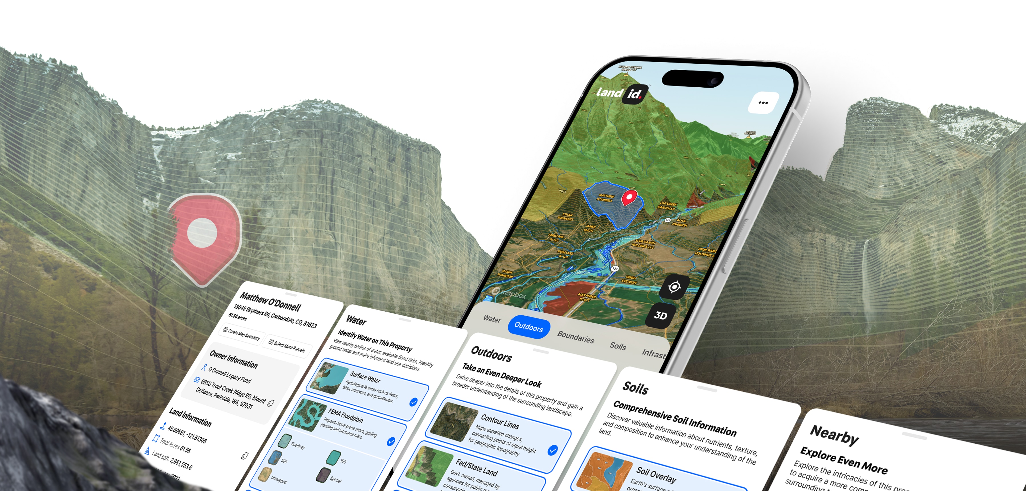
Land id is amazing, and I don’t want my peers having the same advantage. I can say that this program is by far my most important tool.

Image

Anonymous

Image

There's nothing as comprehensive and easy to use out there.

Image

Stephen J B Davis
Christie's International Real Estate

Image

I love all the attributes Land id has to offer. You guys are raising the bar and making it easier and better to use.

Image

Legacy Land Group

Image

Land id provides a lot of the information I need all in one place and reduces my research time quite a bit.

Image

Angela Bruno
City of Trees Real Estate

Image

We use Land id for every property we look at and get under contract. It tells you so much about the property without ever having to step foot onto it. We also use it to create pictures to market properties.

Image

Chris Thomas

Image

Everyone I work with uses Land id® — it's the industry standard. If you're not using it, it's time to upgrade your professional tools and work smarter.

Image

JB
Family Office Real Estate Investor

No items found.

Get Driving Directions

Just Tap & Go

Land id® allows you to easily obtain driving directions that take you straight to your waypoint. Say goodbye to the hassle of getting lost and hello to a seamless navigation experience.

Map image showing individuals parcels with yellow labels and a waypoints icon.
Screenshot of the Land id mobile app showing a directions modal.

Get Driving Directions

Just Tap & Go

Land id® allows you to easily obtain driving directions that take you straight to your waypoint. Say goodbye to the hassle of getting lost and hello to a seamless navigation experience.

Screenshot of the Land id mobile app showing a directions modal.
Map image showing individuals parcels with yellow labels and a waypoints icon.

Get Driving Directions

Just Tap & Go

Land id® allows you to easily obtain driving directions that take you straight to your waypoint. Say goodbye to the hassle of getting lost and hello to a seamless navigation experience.

Map image showing individuals parcels with yellow labels and a waypoints icon.
ImageImage
Screenshot of the Land id mobile app showing a map with parcels labeled in yellow.
A beautiful satellite image of land with various textures.
Pre Label

360˚ Land Panoramas

With Land id®, you can add as many panoramic images as you need to a map. Viewers will have the freedom to move around photos and zoom in and out as they learn about each area of a property.

An aerial land panorama shot with regions outlined in green.

360˚ Land Panoramas

With Land id®, you can add as many panoramic images as you need to a map. Viewers will have the freedom to move around photos and zoom in and out as they learn about each area of a property.

Image

Explore Private Parcel Data & Property Boundaries

Download the Land id app and try for free.

Download on the Apple App StoreGet it on Google Play
Image
Image

Make Your First Map in 3 Min.

Try for FreeTry for free
Image

Join Land id & Start Designing in Canva Today

Try for FreeTry for free
Image

Watch a demo

Explore all that Land id has to offer

If you’re looking for a full exploration of our land mapping software, request a demo with one of our experts today.

Fill out the form below to watch the demo

Demo request received.

One of our experts will reach out shortly to schedule your demo.
Oops! Something went wrong while submitting the form.

FAQs

What does parcel data mean?

Why is accurate parcel data important?

How is a parcel data map created?

How can I access parcel data?

Can parcel data change over time?

What's the difference between a parcel boundary and a property line?

Image

Explore Private Parcel Data & Property Boundaries

Download the Land id app and try for free.

Download on the Apple App StoreGet it on Google Play
Image
Image
Get a Live Demo

Need to see a bit more? Sign up for a live demo today.

Intrigued with Land id® but want to see a bit more? Sign up for a live demo of our land mapping software with our experts today.

Schedule a Demo