Log inSign up
MU Weather Center
13K posts
Image
user avatar
MU Weather Center
@MUweather
Millersville University Weather Information Center. Tweets by Meteorologist & Director Kyle Elliott. Expert Forecasts & Storm Analyses for southeastern PA.
Millersville, PA
millersville.edu/weathercenter/
Joined October 2020
195
Following
3,133
Followers

New to X?

Sign up now to get your own personalized timeline!

Create account

By signing up, you agree to the Terms of Service and Privacy Policy, including Cookie Use.

Terms·Privacy·Cookies·Accessibility·Ads Info·© 2026 X Corp.
Don't miss what's happening
People on X are the first to know.
Log inSign up
  • Pinned
    user avatar
    MU Weather Center
    @MUweather
    Jul 6
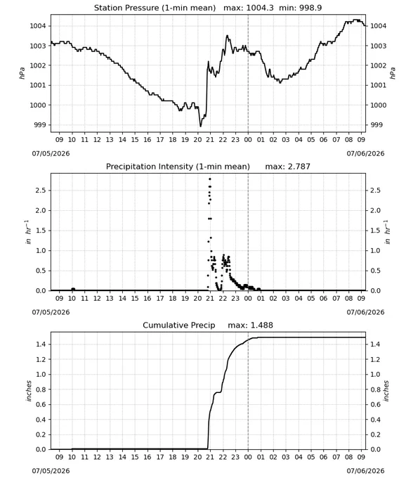
    Our historic #heatwave ended with a literal bang over #FourthofJuly weekend! Sat's storms were responsible for hundreds of wind damage reports in northern MD, southeastern PA & the LSV, & some areas got 4-5" of rain since Sat PM. The Drought Monitor will look very different soon.
    Image
    Image
    Image
    Image
    1.6K
  • user avatar
    MU Weather Center
    @MUweather
    Nov 3, 2025
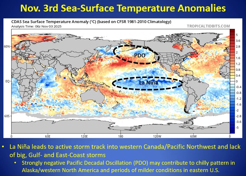
    1/3 Here you go, snow lovers! The moment you've been waiting for is here: my 2025-2026 Winter Outlook! Three primary winter-season influences will be a weak La Niña, strongly-negative Pacific Decadal Oscillation (PDO) & weak stratospheric #PolarVortex (SPV). The weak SPV should..
    Image
    19K
  • user avatar
    MU Weather Center
    @MUweather
    Jan 19, 2024
    It was an honor to celebrate @JoeCalhounWGAL’s retirement in the @millersvilleu Weather Center this evening! He is a true legend in meteorology, & alumni, students, & myself were lucky enough to watch & be a part of some of his final broadcasts. Congratulations, and all the best!
    Image
    Image
    Image
    Image
    4.4K
  • user avatar
    MU Weather Center
    @MUweather
    Feb 16, 2024
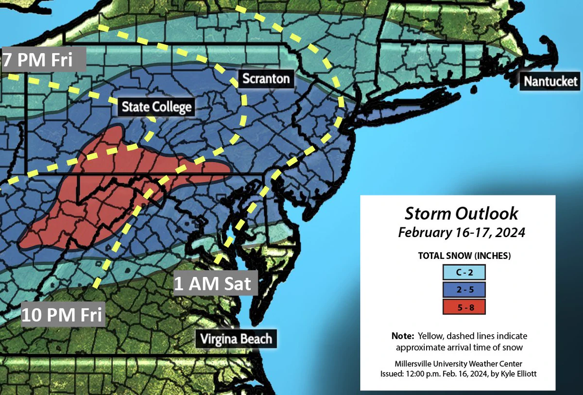
    (1/2) Here you go, snowfans! I've released my Storm Outlook Map for tonight's #winterstorm. The track of this storm has been very consistent, so I have high confidence in my map. I expect a general 3-5" across the region with locally higher amounts of 6-7" in the heaviest bands..
    Image
    8.4K
  • user avatar
    MU Weather Center
    @MUweather
    Jan 17, 2024
    Here it is, snow-lovers! My "First Call" Storm Outlook Map is hot off the press! I'm expecting a widespread, plowable snowfall across all of PA and most of NJ. However, limited moisture and the system's weakness will put a cap on high-end snow potential. #PAwx #NYwx #MDwx #NJwx
    Image
    14K
  • user avatar
    MU Weather Center
    @MUweather
    Jan 5, 2025
    Here you go, snowfans.. the moment you've been waiting for: my "Storm Outlook" map for our impending #snowstorm! I expect a rather tight gradient between 6"+ and <3" of snow on both the northern and southern edges of the system with the "jackpot zone" btw. I-70 and northern VA.
    Image
    8.6K
  • user avatar
    MU Weather Center
    @MUweather
    Jun 28, 2023
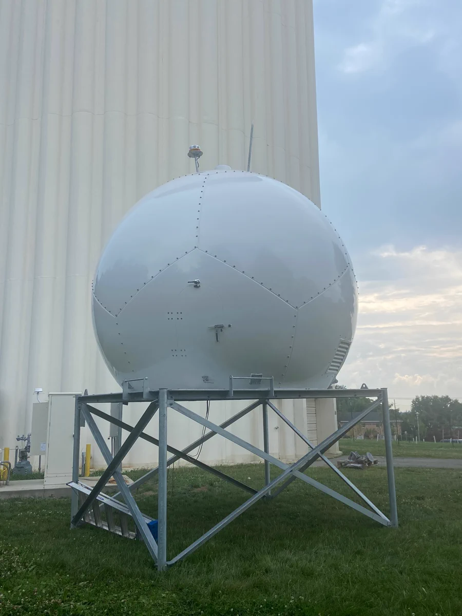
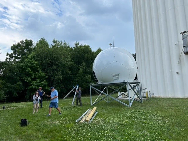
    Here is a close-up picture of the radome — a structural, weatherproof enclosure that protects radar systems from precipitation but still allows signals to be received without any interference — for @millersvilleu’s new @climavision X-band, gap-filling radar! #PAwx
    Image
    6.4K
  • user avatar
    MU Weather Center
    @MUweather
    Sep 10, 2021
    For those who are wondering, this @MUweather account has now transitioned from @HorstWeather (Eric Horst) to me (Kyle Elliott), the new MU Weather Information Center Director. I am filled with gratitude for this incredible opportunity and thank Eric for over 3 decades of service!
  • user avatar
    MU Weather Center
    @MUweather
    Jun 27, 2023
    So exciting! The radar will help “fill the gap” between the @NWSStateCollege, @NWS_MountHolly, and @NWS_BaltWash radars and provide better resolution on precipitation in the local area.
    user avatar
    Millersville University
    @millersvilleu
    Jun 27, 2023
    Today, we’re installing a @climavision X-band weather surveillance radar on campus! The new radar will cover the area between the 3 closest @NWS radars in State College, Mt. Holly, N.J. & Sterling, Va. Stay tuned for more photos! @MUweather
    Image
    Image
    4.9K
  • user avatar
    MU Weather Center
    @MUweather
    Feb 12, 2024
    (1/2) Here you go, snowfans! I've released my Storm Outlook Map for Tuesday's #winterstorm. This is a low-confidence forecast due to the dramatic southward shift in the storm's track over the past 24 hours. The dynamics support a narrow band of heavy snow from the Lehigh Valley..
    Image
    10K
  • user avatar
    MU Weather Center
    @MUweather
    Feb 13, 2024
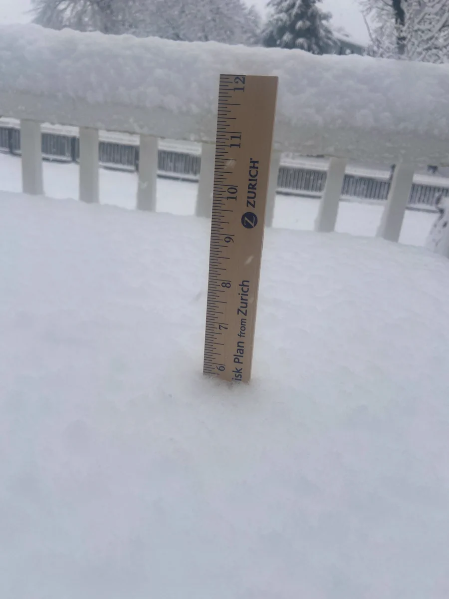
    7:30 AM measurement is 5.7” on my back deck table.. 1.6” since 6:40 AM. Snowfall rates have been just under 2” per hour since 4:15 AM. Talk about a thump! #PAwx #snowstorm
    Image
    8.1K
  • user avatar
    MU Weather Center
    @MUweather
    Jun 9, 2023
    The 2022-2023 Weather Challenge forecasting competition was a massive success for @millersvilleu Meteorology students! We had 12 total winners this season, and their trophies arrived this week. Congratulations! 🎉
    Image
    14K
  • user avatar
    MU Weather Center
    @MUweather
    Mar 11, 2022
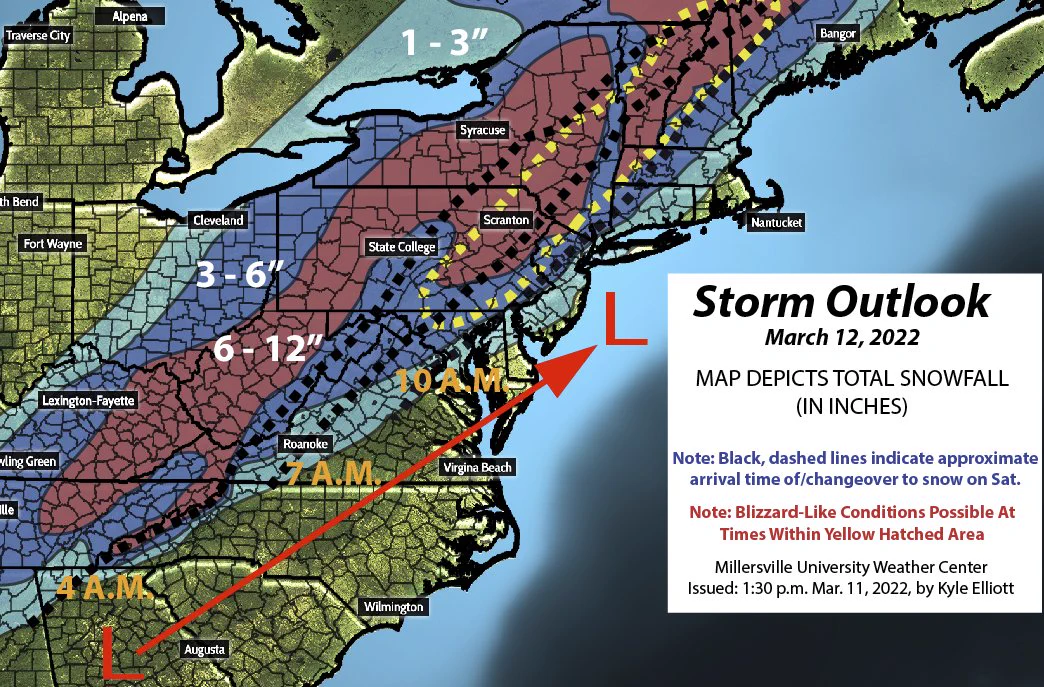
    Here you go, extreme-weather fans! My Storm Outlook Map for the #BombCyclone is "hot off the press!" This storm will have it all: heavy #snow, damaging winds, crashing temps, bitter cold, whiteout conditions, & snow-packed/icy roads. Stay safe! #weatheraware #MarchMadness #PAwx
    Image
  • user avatar
    MU Weather Center
    @MUweather
    Feb 14, 2025
    Unfortunately, the talk of a "major snowstorm" late next week has merit. The MJO is in Phase 8, & we'll also have a ridge in the West & west-based, -NAO. All of this *could* add up to the last image.. a bona fide Nor'easter. However, you can't shovel potential! #StayTuned
    Image
    Image
    Image
    Image
    12K
Advertisement
Advertisement