Log inSign up
NWS State College
38.3K posts
Image
user avatar
NWS State College
@NWSStateCollege
Official X Account for National Weather Service State College, PA. Details: weather.gov/nws_x
State College, PA
weather.gov/statecollege
Joined June 2012
546
Following
26.5K
Followers

New to X?

Sign up now to get your own personalized timeline!

Create account

By signing up, you agree to the Terms of Service and Privacy Policy, including Cookie Use.

Terms·Privacy·Cookies·Accessibility·Ads Info·© 2026 X Corp.
Don't miss what's happening
People on X are the first to know.
Log inSign up
  • user avatar
    NWS State College
    @NWSStateCollege
    2h
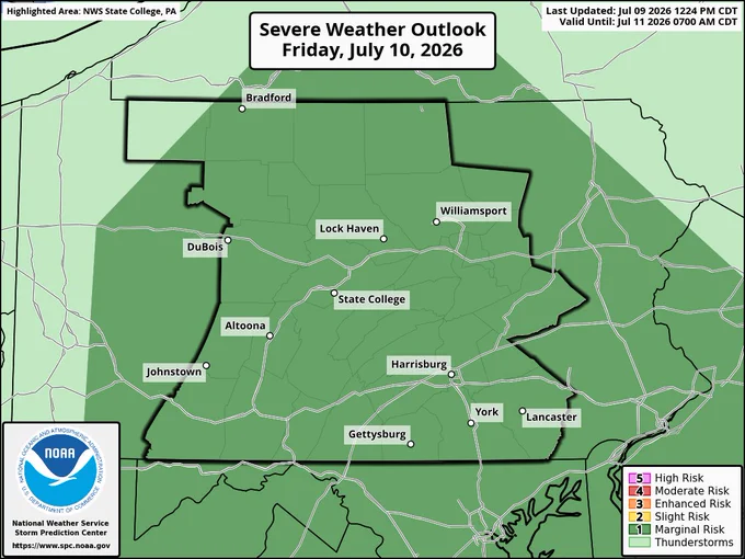
    ☔️ The heavy rain threat evening has ended for the evening; therefore, the Flood Watch has been dropped across the region. A couple of showers remain but will decrease in intensity over the next couple of hours. Flooding and severe threat returns tomorrow afternoon/evening. #PAwx
    Image
    Image
    786
  • user avatar
    NWS State College
    @NWSStateCollege
    4h
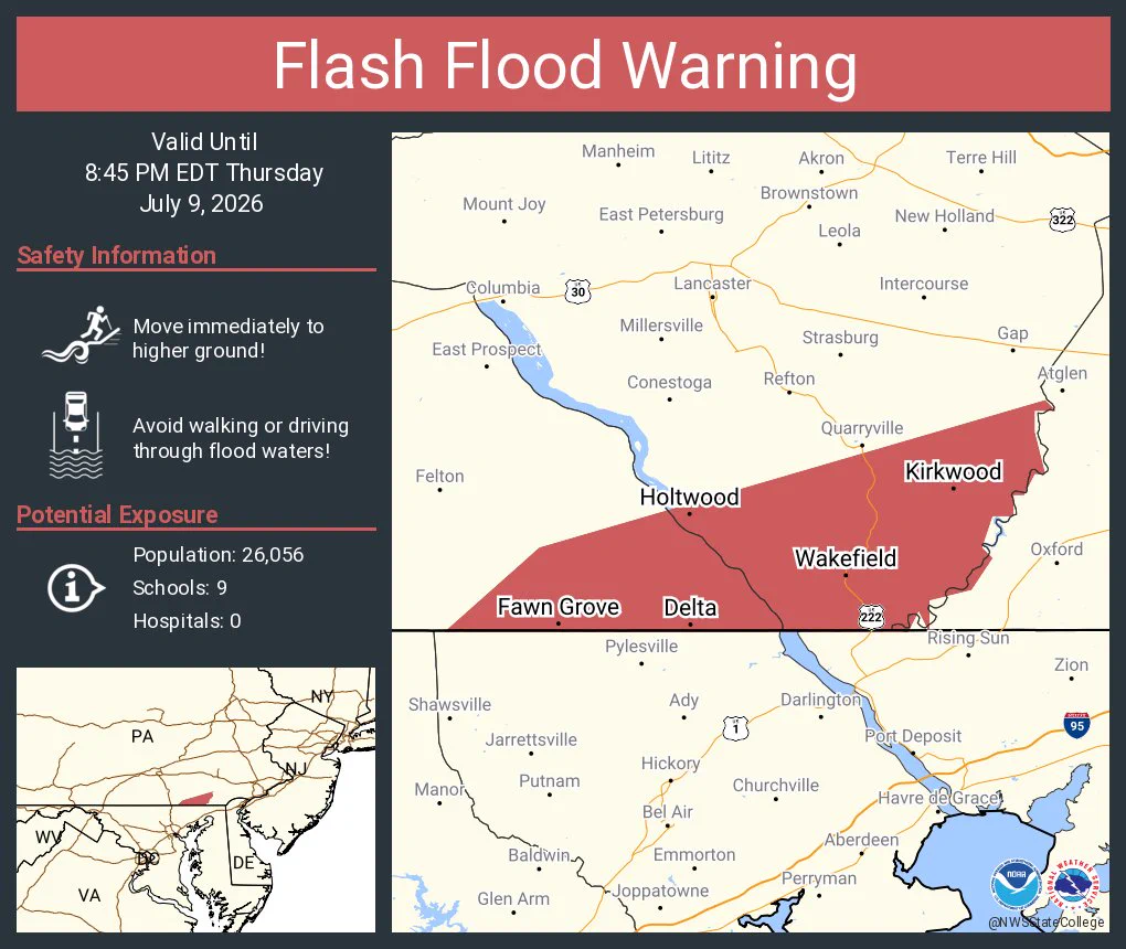
    Flash Flood Warning including Delta PA, Wakefield PA and Fawn Grove PA until 8:45 PM EDT
    This graphic displays a flash flood warning plotted on a map. The warning is in effect until 8:45 PM EDT. The warning includes Delta PA, Wakefield PA and Fawn Grove PA.  This warning is for Southeastern Lancaster County in south central Pennsylvania and Southeastern York County in south central Pennsylvania. Avoid walking or driving through flood waters! Move immediately to higher ground! There are 26,056 people in the warning along with 9 schools and 0 hospitals.
    1.1K
  • user avatar
    NWS State College
    @NWSStateCollege
    5h
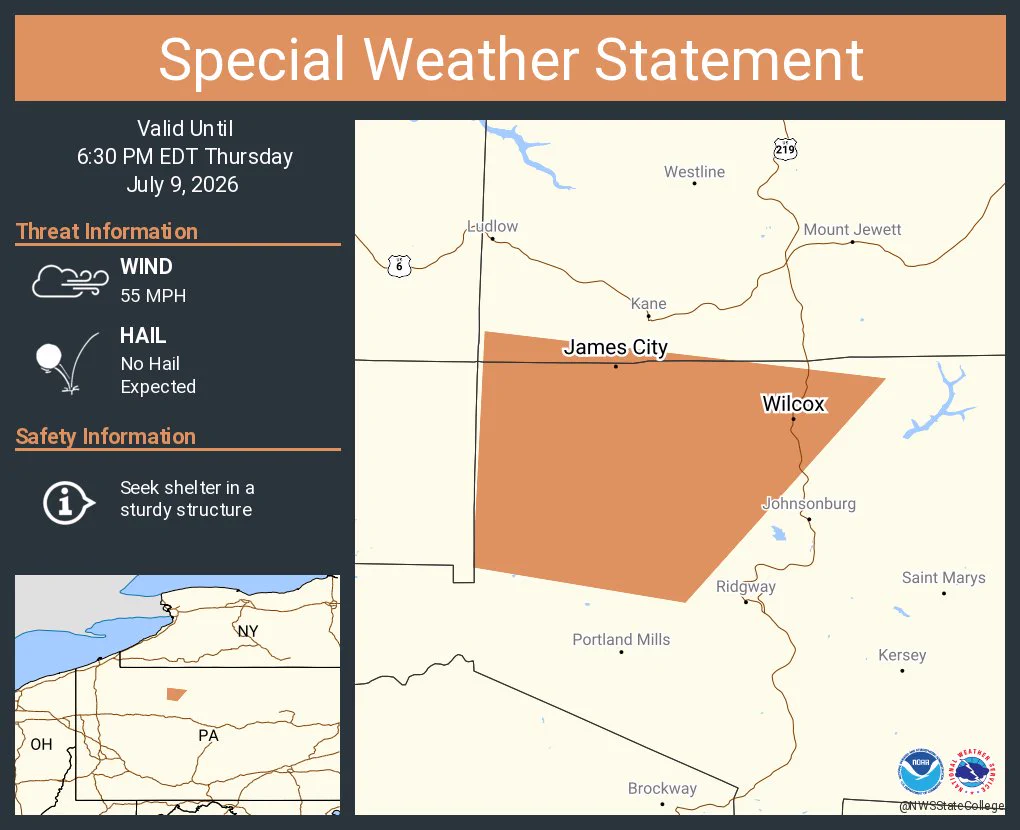
    A special weather statement has been issued for Wilcox PA and James City PA until 6:30 PM EDT
    This graphic displays a special weather statement plotted on a map. The statement is in effect until 6:30 PM EDT.  The statement includes Wilcox PA and  James City PA.  A STRONG THUNDERSTORM WILL IMPACT NORTHWESTERN ELK AND SOUTHWESTERN MCKEAN COUNTIES THROUGH 630 PM EDT. The threats associated with this storm are wind gusts up to 55 MPH and no hail is expected. Seek shelter in a sturdy structure until the storm passes.
    905
  • user avatar
    NWS State College
    @NWSStateCollege
    6h
    A special weather statement has been issued for Gettysburg PA, Littlestown PA and Carroll Valley PA until 5:30 PM EDT
    This graphic displays a special weather statement plotted on a map. The statement is in effect until 5:30 PM EDT.  The statement includes Gettysburg PA, Littlestown PA and  Carroll Valley PA.  A STRONG THUNDERSTORM WILL IMPACT SOUTHWESTERN ADAMS COUNTY THROUGH 530 PM EDT. The threats associated with this storm are wind gusts up to 55 MPH and no hail is expected. Seek shelter in a sturdy structure until the storm passes.
    1K
  • user avatar
    NWS State College
    @NWSStateCollege
    6h
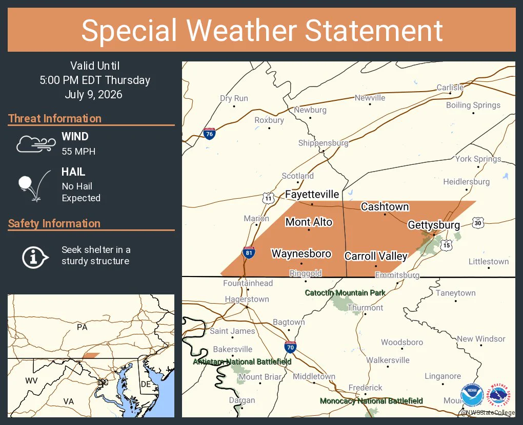
    A special weather statement has been issued for Waynesboro PA, Gettysburg PA and Carroll Valley PA until 5:00 PM EDT
    This graphic displays a special weather statement plotted on a map. The statement is in effect until 5:00 PM EDT.  The statement includes Waynesboro PA, Gettysburg PA and  Carroll Valley PA.  STRONG THUNDERSTORMS WILL IMPACT SOUTHWESTERN ADAMS AND SOUTHEASTERN FRANKLIN COUNTIES THROUGH 500 PM EDT. The threats associated with this storm are wind gusts up to 55 MPH and no hail is expected. Seek shelter in a sturdy structure until the storm passes.
    1K
  • user avatar
    NWS State College
    @NWSStateCollege
    7h
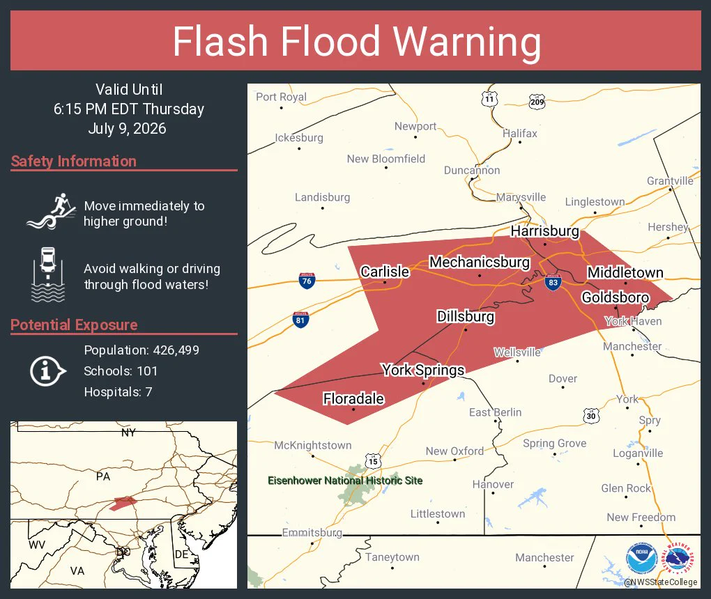
    Flash Flood Warning including Harrisburg PA, Carlisle PA and Mechanicsburg PA until 6:15 PM EDT
    This graphic displays a flash flood warning plotted on a map. The warning is in effect until 6:15 PM EDT. The warning includes Harrisburg PA, Carlisle PA and Mechanicsburg PA.  This warning is for Northwestern Adams County in south central Pennsylvania, Eastern Cumberland County in south central Pennsylvania, Southwestern Dauphin County in south central Pennsylvania and Northwestern York County in south central Pennsylvania. Avoid walking or driving through flood waters! Move immediately to higher ground! There are 426,499 people in the warning along with 101 schools and 7 hospitals.
    1.3K
  • user avatar
    NWS State College
    @NWSStateCollege
    7h
    A special weather statement has been issued for Mercersburg PA, McConnellsburg PA and Fort Loudon PA until 4:00 PM EDT
    This graphic displays a special weather statement plotted on a map. The statement is in effect until 4:00 PM EDT.  The statement includes Mercersburg PA, McConnellsburg PA and  Fort Loudon PA.  The threats associated with this storm are wind gusts up to 50 MPH and no hail is expected. Seek shelter in a sturdy structure until the storm passes.
    954
  • user avatar
    NWS State College
    @NWSStateCollege
    8h
    A special weather statement has been issued for Pine Grove PA, Friedensburg PA and Auburn PA until 3:30 PM EDT
    This graphic displays a special weather statement plotted on a map. The statement is in effect until 3:30 PM EDT.  The statement includes Pine Grove PA, Friedensburg PA and  Auburn PA.  A STRONG THUNDERSTORM WILL IMPACT SOUTHEASTERN SCHUYLKILL COUNTY THROUGH 330 PM EDT. The threats associated with this storm are wind gusts up to 55 MPH and no hail is expected. Seek shelter in a sturdy structure until the storm passes.
    1.1K
  • user avatar
    NWS State College
    @NWSStateCollege
    8h
    Flash Flood Warning including Lancaster PA, Millersville PA and New Holland PA until 5:30 PM EDT
    This graphic displays a flash flood warning plotted on a map. The warning is in effect until 5:30 PM EDT. The warning includes Lancaster PA, Millersville PA and New Holland PA.  This warning is for East Central Lancaster County in south central Pennsylvania. Avoid walking or driving through flood waters! Move immediately to higher ground! There are 160,931 people in the warning along with 35 schools and 2 hospitals.
    1.2K
  • user avatar
    NWS State College
    @NWSStateCollege
    8h
    A special weather statement has been issued for Lancaster PA, Lititz PA and Millersville PA until 3:15 PM EDT
    This graphic displays a special weather statement plotted on a map. The statement is in effect until 3:15 PM EDT.  The statement includes Lancaster PA, Lititz PA and  Millersville PA.  A STRONG THUNDERSTORM WILL IMPACT EAST CENTRAL LANCASTER COUNTY THROUGH 315 PM EDT. The threats associated with this storm are wind gusts up to 50 MPH and no hail is expected. Seek shelter in a sturdy structure until the storm passes.
    1.1K
  • user avatar
    NWS State College
    @NWSStateCollege
    9h
    Flash Flood Warning including Ephrata PA, Columbia PA and Lititz PA until 4:15 PM EDT
    This graphic displays a flash flood warning plotted on a map. The warning is in effect until 4:15 PM EDT. The warning includes Ephrata PA, Columbia PA and Lititz PA.  This warning is for Northeastern Adams County in south central Pennsylvania, Northern Lancaster County in south central Pennsylvania and Northwestern York County in south central Pennsylvania. Avoid walking or driving through flood waters! Move immediately to higher ground! There are 341,510 people in the warning along with 87 schools and 2 hospitals.
    1.3K
  • user avatar
    NWS State College
    @NWSStateCollege
    9h
    ⚠️Flood Watch expanded to include the southern tier of central PA #PAwx
    Image
    1.4K
  • NWS State College reposted
    user avatar
    NWS Weather Prediction Center
    @NWSWPC
    10h
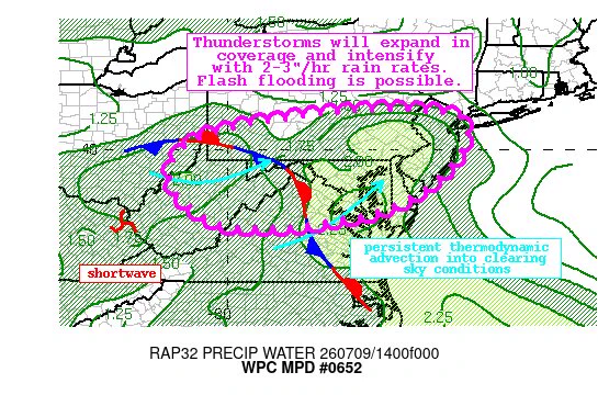
    #WPC_MD 0652 affecting Central Appalachians through the Mid-Atlantic, #nywx #njwx #pawx #dewx #mdwx #vawx #dcwx #wvwx #ohwx, wpc.ncep.noaa.gov/metwatch/metwa…
    Image
    12K
  • user avatar
    NWS State College
    @NWSStateCollege
    16h
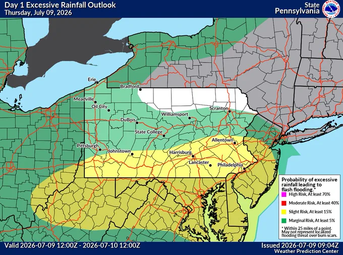
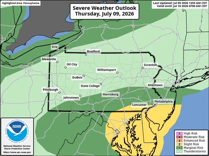
    Slow moving showers are moving east across Southern PA this morning. Further scattered t-storm development is expected this afternoon. Repeating storms and heavy bursts of rain yield concerns for flash flooding in our southern tier. Isolated damaging wind gusts are possible too
    Image
    Image
    Image
    GIF
    1.7K
Advertisement
Advertisement