Log inSign up
NWS Houston
49.6K posts
Image
user avatar
NWS Houston
@NWSHouston
Official X account for the National Weather Service Houston/Galveston TX. Details: weather.gov/nws_x
Houston, Texas
weather.gov/hgx
Joined June 2012
504
Following
133.6K
Followers

New to X?

Sign up now to get your own personalized timeline!

Create account

By signing up, you agree to the Terms of Service and Privacy Policy, including Cookie Use.

Terms·Privacy·Cookies·Accessibility·Ads Info·© 2026 X Corp.
Don't miss what's happening
People on X are the first to know.
Log inSign up
  • user avatar
    NWS Houston
    @NWSHouston
    11h
    We know it's been hot and miserable. But perhaps we can manage to ease the heat as we go into early next week as shower/thunderstorm chances increase. #TXwx #HOUwx
    Image
    3.7K
  • user avatar
    NWS Houston
    @NWSHouston
    11h
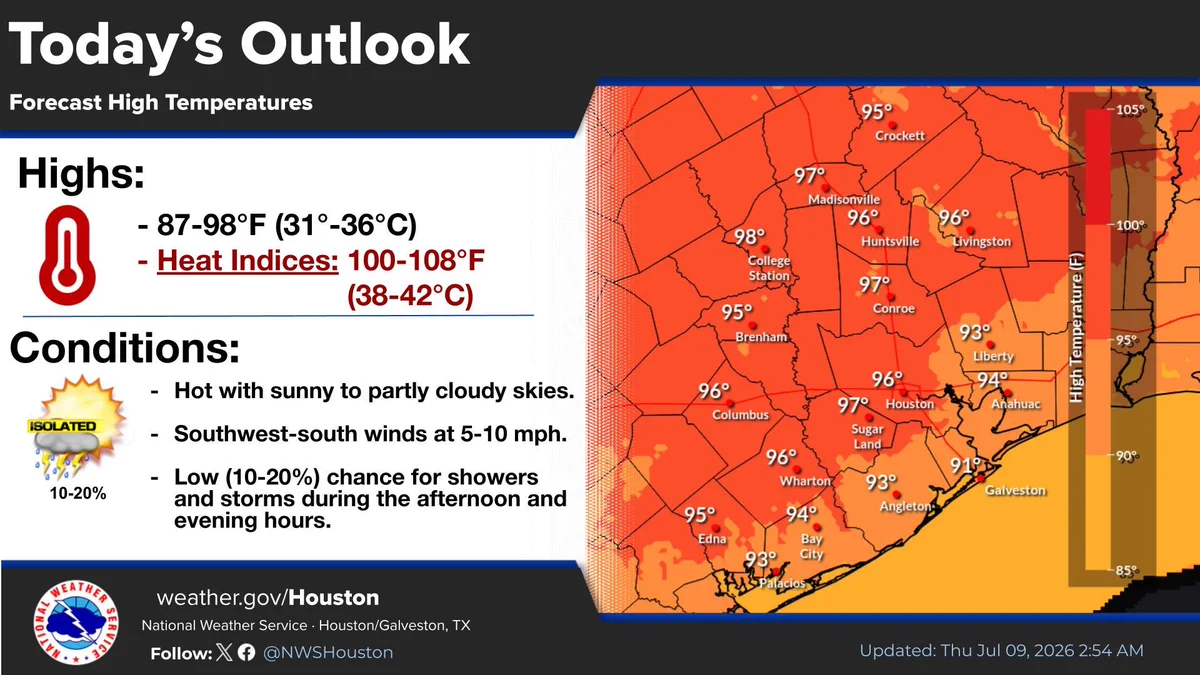
    Hot and humid conditions will continue. High temps will climb into the mid to upper 90s for most. Heat indices top out in the 100-108° range. There is a low chance (10-20%) for showers and thunderstorms. #TXwx
    Today's Outlook: Forecast High Temperatures from the National Weather Service Houston/Galveston, TX, updated July 9, 2026. The left side outlines "Highs" of 87 to 98 degrees Fahrenheit (31 to 36 degrees Celsius) with heat indices of 100 to 108 degrees Fahrenheit (38 to 42 degrees Celsius). "Conditions" list: Hot with sunny to partly cloudy skies; Southwest-south winds at 5 to 10 mph; and a low 10 to 20 percent chance for isolated afternoon/evening showers and storms. The right side features a color-coded temperature map of southeast Texas showing forecast highs ranging from 91 degrees in Galveston to 98 degrees in College Station, with Houston at 96 degrees. The graphic was updated on Thursday, July 9, 2026, at 2:56 AM.
    3.5K
  • user avatar
    NWS Houston
    @NWSHouston
    21h
    Continued heat is expected across the region. High temps will warm into the mid to upper 90s again today, with maximum heat indices reaching into the triple digits. Slightly cooler temperatures by this weekend, with rain and thunderstorm chances increasing. #TXwx
    Upcoming Heat & Precipitation Chances, updated July 9, 2026. Bullet points note high temperatures in the mid to upper 90s today, low to mid 90s this weekend into next week, heat indices of 100-108°F, and increasing shower and storm chances. Two data tables show daily forecasts from July 9 to July 15 for 17 Texas cities including Houston, Katy, and Galveston. The left table details Maximum Temperature Forecasts mostly ranging from 88 to 97°F. The right table shows Probability of Precipitation, with chances peaking on Monday, July 13, reaching up to 70%. A "Heat Safety" section features six orange icons with tips: take frequent breaks in A/C, stay hydrated, reduce time outdoors between 10 AM and 6 PM, recognize heat illness, check on elderly, kids, and pets, and wear light-weight, light-colored clothing.
    3.9K
  • user avatar
    NWS Houston
    @NWSHouston
    21h
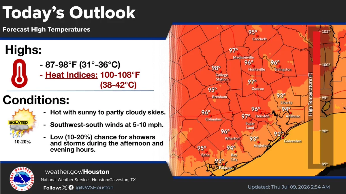
    Hot and humid conditions will continue. High temps will climb into the mid to upper 90s for most. Heat indices top out in the 100-108° range. There is a low chance (10-20%) for showers and thunderstorms. #TXwx
    Today's Outlook: Forecast High Temperatures from the National Weather Service Houston/Galveston, TX, updated July 9, 2026. The left side outlines "Highs" of 87 to 98 degrees Fahrenheit (31 to 36 degrees Celsius) with heat indices of 100 to 108 degrees Fahrenheit (38 to 42 degrees Celsius). "Conditions" list: Hot with sunny to partly cloudy skies; Southwest-south winds at 5 to 10 mph; and a low 10 to 20 percent chance for isolated afternoon/evening showers and storms. The right side features a color-coded temperature map of southeast Texas showing forecast highs ranging from 91 degrees in Galveston to 98 degrees in College Station, with Houston at 96 degrees. The graphic was updated on Thursday, July 9, 2026, at 2:56 AM.
    3.6K
  • user avatar
    NWS Houston
    @NWSHouston
    Jul 8
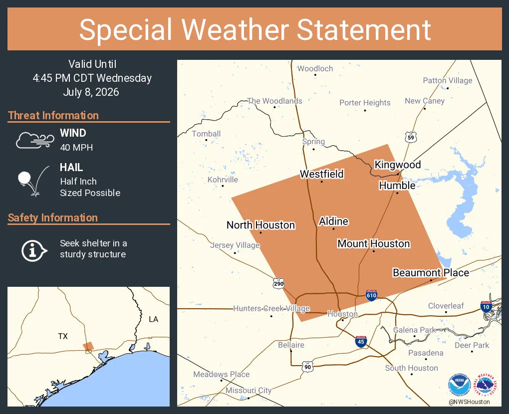
    A special weather statement has been issued for Aldine TX, Humble TX and Bammel TX until 4:45 PM CDT
    This graphic displays a special weather statement plotted on a map. The statement is in effect until 4:45 PM CDT.  The statement includes Aldine TX, Humble TX and  Bammel TX.  A STRONG THUNDERSTORM WILL IMPACT SOUTHEASTERN MONTGOMERY AND CENTRAL HARRIS COUNTIES THROUGH 445 PM CDT. The threats associated with this storm are wind gusts up to 40 MPH and half inch sized hail. Seek shelter in a sturdy structure until the storm passes.
    4.7K
  • NWS Houston reposted
    user avatar
    National Hurricane Center
    @NHC_Atlantic
    Jul 8
    Wed, July 8: The Atlantic appears to remain quiet as we head into the middle part of July, with tropical cyclone formation not expected during the next 7 days. Only having one named storm (Arthur) at this point in the season is not entirely abnormal. The average date for the
    Image
    Image
    Image
    95K
  • user avatar
    NWS Houston
    @NWSHouston
    Jul 8
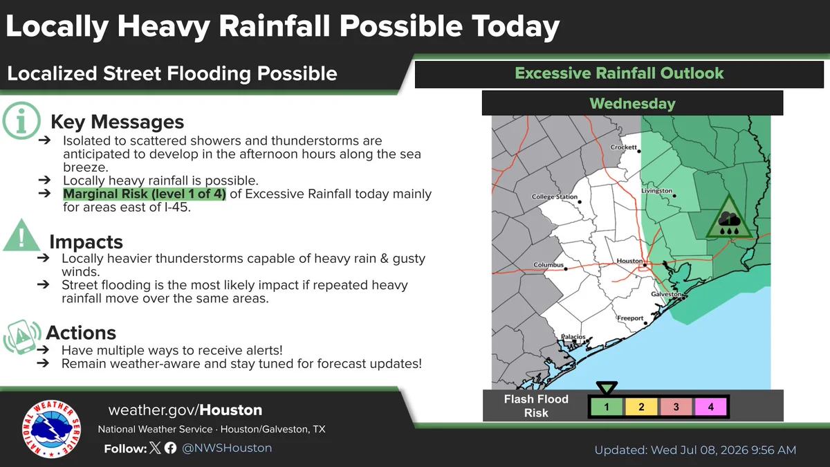
    With scattered showers and thunderstorms expected to develop again this afternoon, there is potential for locally heavy downpours that could lead to localized street flooding. This potential is mainly for areas along and east of I-45. #TXwx #HOUwx #GLSwx
    Image
    3.6K
  • user avatar
    NWS Houston
    @NWSHouston
    Jul 8
    Today’s forecast: Hot, humid, and a chance for those pop-up storms later! ☀️⛈️ Highs hitting up to 97°F with heat indices over 108°F. Hydrate, take breaks, and enjoy the summer weather safely! #HoustonWeather #HeatSafety
    Graphic from the National Weather Service, Houston/Galveston, dated July 8, 2026. Today's forecast indicates hot and humid conditions with patchy morning fog and light south-southwest winds. High temperatures are expected to reach 89-97°F, with heat indices between 100-108°F+. There is a 20-45% chance of afternoon and evening showers and thunderstorms. Visit weather.gov/houston for the latest updates.
    Infographic from the National Weather Service, Houston/Galveston, dated July 8, 2026. It warns that summer heat in Southeast Texas can be dangerous, with highs in the 90s and heat indices between 100-105°F. It provides the following safety tips: check on the elderly, kids, and pets; stay hydrated; wear lightweight, light-colored clothing; reduce time outdoors between 10 AM and 6 PM; and stay in a cool place during the heat of the day. The graphic encourages viewers to "Stay Cool. Stay Hydrated. Stay Safe" and directs them to weather.gov/Houston for the latest updates.
    4.3K
  • user avatar
    NWS Houston
    @NWSHouston
    Jul 8
    Though there will be some isolated-scattered storms around on Wednesday, things aren't looking quite as active as they were today.
    Image
    4.8K
  • user avatar
    NWS Houston
    @NWSHouston
    Jul 8
    A special weather statement has been issued for Houston TX, Pasadena TX and Channelview TX until 8:45 PM CDT
    This graphic displays a special weather statement plotted on a map. The statement is in effect until 8:45 PM CDT.  The statement includes Houston TX, Pasadena TX and  Channelview TX.  A STRONG THUNDERSTORM WILL IMPACT SOUTHEASTERN HARRIS COUNTY THROUGH 845 PM CDT. The threats associated with this storm are wind gusts up to 40 MPH and no hail is expected. Seek shelter in a sturdy structure until the storm passes.
    4.6K
  • user avatar
    NWS Houston
    @NWSHouston
    Jul 7
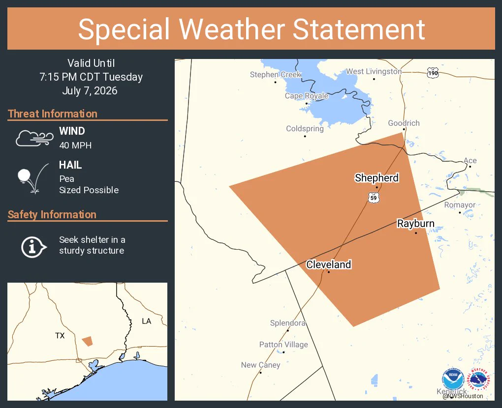
    A special weather statement has been issued for Cleveland TX, Shepherd TX and Rayburn TX until 7:15 PM CDT
    This graphic displays a special weather statement plotted on a map. The statement is in effect until 7:15 PM CDT.  The statement includes Cleveland TX, Shepherd TX and  Rayburn TX.  The threats associated with this storm are wind gusts up to 40 MPH and pea sized hail. Seek shelter in a sturdy structure until the storm passes.
    4K
  • user avatar
    NWS Houston
    @NWSHouston
    Jul 7
    Aviso de Tormenta Severa incluye West Livingston TX, Point Blank TX, Cape Royale TX hasta las 6:45 PM CDT
    Este gráfico muestra la localización en el mapa de un aviso de tormenta severa. El aviso estará en efecto hasta las 6:45 PM CDT. El aviso incluye a West Livingston TX, Point Blank TX, Cape Royale TX. El aviso incluye el noroeste del condado de San Jacinto en el sureste de Texas y el suroeste del condado de Polk en el sureste de Texas. Las amenazas asociadas a este aviso son: ráfagas de viento de 60 MPH y granizo del tamaño de una moneda de un centavo. Hay 13,530 personas bajo este aviso incluyendo 0 escuelas y 0 hospitales.
    3.6K
  • user avatar
    NWS Houston
    @NWSHouston
    Jul 7
    Severe Thunderstorm Warning including West Livingston TX, Point Blank TX and Cape Royale TX until 6:45 PM CDT
    This graphic displays a severe thunderstorm warning plotted on a map. The warning is in effect until 6:45 PM CDT. The warning includes West Livingston TX, Point Blank TX and Cape Royale TX.  This warning is for Northwestern San Jacinto County in southeastern Texas and Southwestern Polk County in southeastern Texas. The threats associated with this warning are wind gusts up to 60 MPH and penny sized hail. There are 13,530 people in the warning along with 0 schools and 0 hospitals.
    3.6K
  • user avatar
    NWS Houston
    @NWSHouston
    Jul 7
    A special weather statement has been issued for Onalaska TX, Coldspring TX and Point Blank TX until 6:45 PM CDT
    This graphic displays a special weather statement plotted on a map. The statement is in effect until 6:45 PM CDT.  The statement includes Onalaska TX, Coldspring TX and  Point Blank TX.  The threats associated with this storm are wind gusts up to 50 MPH and half inch sized hail. Seek shelter in a sturdy structure until the storm passes.
    3.5K
Advertisement
Advertisement