Log inSign up
NWS Lincoln IL
37.1K posts
Image
user avatar
NWS Lincoln IL
@NWSLincolnIL
Official X account for the National Weather Service Lincoln, IL. Details: weather.gov/nws_x
Lincoln, Illinois
weather.gov/lincoln
Joined June 2012
218
Following
26.4K
Followers

New to X?

Sign up now to get your own personalized timeline!

Create account

By signing up, you agree to the Terms of Service and Privacy Policy, including Cookie Use.

Terms·Privacy·Cookies·Accessibility·Ads Info·© 2026 X Corp.
Don't miss what's happening
People on X are the first to know.
Log inSign up
  • user avatar
    NWS Lincoln IL
    @NWSLincolnIL
    27m
    Isolated severe thunderstorms in southern portions of central IL from around 3 to 10 pm today. Main threats locally damaging wind gusts and heavy rain, but isolated large hail and a tornado or two possible as well, mainly south of a Jacksonville to Effingham line. #ilwx
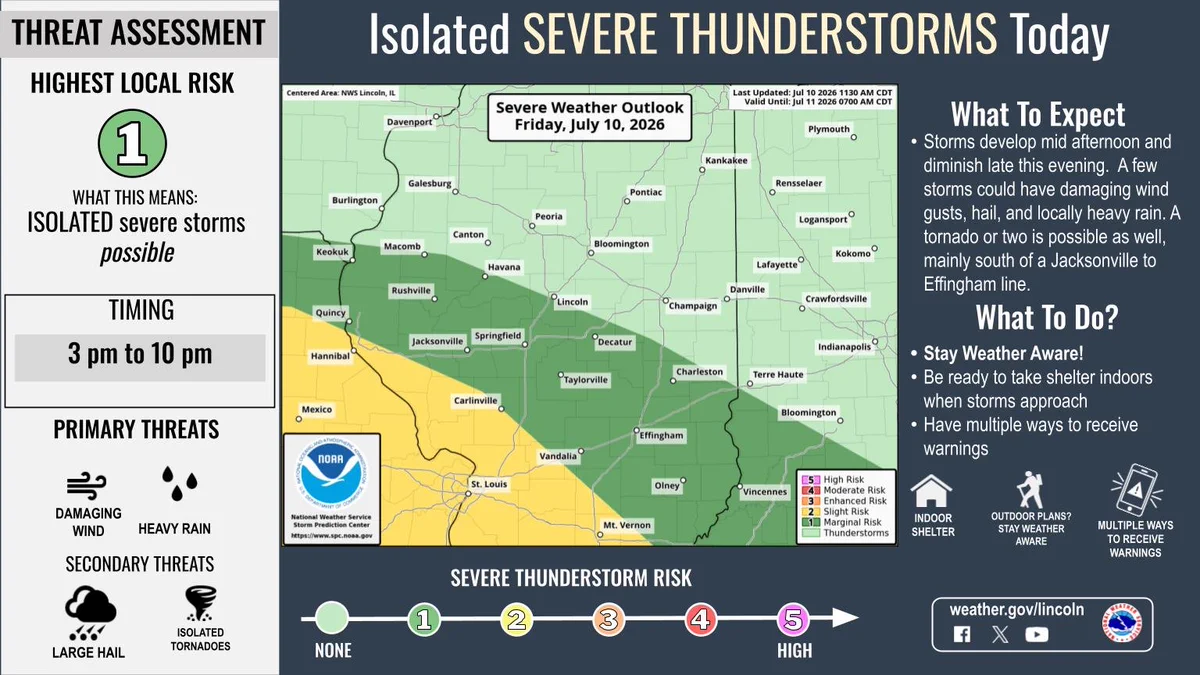
    Graphic showing that a frontal boundary will stall over portions of southern Illinois today and will be the focus for strong to severe thunderstorms from around 3 to 10 pm today. The main threats will be locally damaging wind gusts and heavy rain, but isolated large hail is possible as well, and a tornado or two can't be ruled out, mainly south of a Jacksonville to Effingham line.
    526
  • user avatar
    NWS Lincoln IL
    @NWSLincolnIL
    4h
    Strong to severe thunderstorms possible from around 3 to 10 pm today for southern portions of central IL. Main threats: locally damaging wind gusts and heavy rain, but isolated large hail possible as well, and a tornado or two can't be ruled out. #ilwx
    Graphic showing that a frontal boundary will stall over portions of southern Illinois today and will be the focus for strong to severe thunderstorms from around 3 to 10 pm today. The main threats will be locally damaging wind gusts and heavy rain, but isolated large hail is possible as well, and a tornado or two can't be ruled out.
    1.1K
  • user avatar
    NWS Lincoln IL
    @NWSLincolnIL
    10h
    Scattered storms will affect the area this afternoon and evening, a few of which could be severe. Additional thunderstorm chances will occur Saturday, south of I-72. After that, drier weather will dominate, along with seasonable temperatures. #ILwx
    map of todays highs right, 4 day forecast with weather icons and highs and lows on left
    1.3K
  • user avatar
    NWS Lincoln IL
    @NWSLincolnIL
    10h
    A frontal boundary will stall over portions of southern Illinois today and will be the focus for strong to severe thunderstorms, this afternoon and evening. #ILwx
    Map of today's severe thunderstorm outlook center, text details left and right
    1.1K
  • user avatar
    NWS Lincoln IL
    @NWSLincolnIL
    16h
    Aviso de Tormenta Severa continúa Lawrenceville IL, Saint Francisville IL, Billett IL hasta las 8:00 PM CDT
    Este gráfico muestra la localización en el mapa de un aviso de tormenta severa. El aviso estará en efecto hasta las 8:00 PM CDT. El aviso incluye a Lawrenceville IL, Saint Francisville IL, Billett IL. El aviso incluye el este del condado de Richland Is Cancelled. Las amenazas asociadas a este aviso son: ráfagas de viento de 60 MPH y granizo del tamaño de una moneda de veinticinco centavos. Hay 6,240 personas bajo este aviso incluyendo 4 escuelas y 0 hospitales.
    1.3K
  • user avatar
    NWS Lincoln IL
    @NWSLincolnIL
    16h
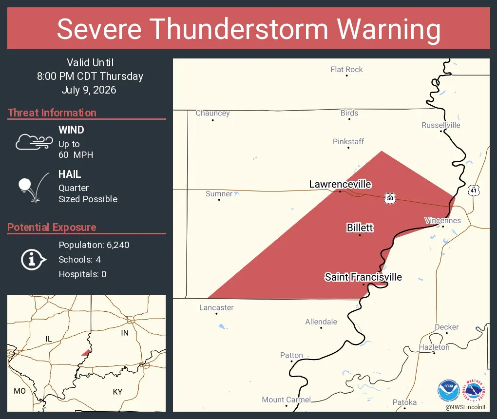
    Severe Thunderstorm Warning continues for Lawrenceville IL, Saint Francisville IL and Billett IL until 8:00 PM CDT
    This graphic displays a severe thunderstorm warning plotted on a map. The warning is in effect until 8:00 PM CDT. The warning includes Lawrenceville IL, Saint Francisville IL and Billett IL.  This warning is for Eastern Richland County Is Cancelled. The threats associated with this warning are wind gusts up to 60 MPH and quarter sized hail. There are 6,240 people in the warning along with 4 schools and 0 hospitals.
    1.2K
  • user avatar
    NWS Lincoln IL
    @NWSLincolnIL
    17h
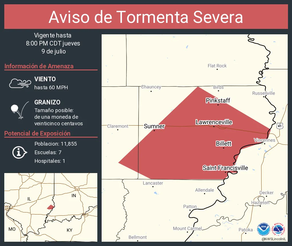
    Aviso de Tormenta Severa incluye Lawrenceville IL, Sumner IL, Bridgeport IL hasta las 8:00 PM CDT
    Este gráfico muestra la localización en el mapa de un aviso de tormenta severa. El aviso estará en efecto hasta las 8:00 PM CDT. El aviso incluye a Lawrenceville IL, Sumner IL, Bridgeport IL. El aviso incluye el condado de Lawrence en el sureste de Illinois y el este del condado de Richland en el sureste de Illinois. Las amenazas asociadas a este aviso son: ráfagas de viento de 60 MPH y granizo del tamaño de una moneda de veinticinco centavos. Hay 11,855 personas bajo este aviso incluyendo 7 escuelas y 1 hospital.
    1.4K
  • user avatar
    NWS Lincoln IL
    @NWSLincolnIL
    17h
    Severe Thunderstorm Warning including Lawrenceville IL, Sumner IL and Bridgeport IL until 8:00 PM CDT
    This graphic displays a severe thunderstorm warning plotted on a map. The warning is in effect until 8:00 PM CDT. The warning includes Lawrenceville IL, Sumner IL and Bridgeport IL.  This warning is for Lawrence County in southeastern Illinois and Eastern Richland County in southeastern Illinois. The threats associated with this warning are wind gusts up to 60 MPH and quarter sized hail. There are 11,855 people in the warning along with 7 schools and 1 hospital.
    1K
  • user avatar
    NWS Lincoln IL
    @NWSLincolnIL
    18h
    Aviso de Tormenta Severa continúa Minonk IL, Benson IL, Rutland IL hasta las 7:00 PM CDT
    Este gráfico muestra la localización en el mapa de un aviso de tormenta severa. El aviso estará en efecto hasta las 7:00 PM CDT. El aviso incluye a Minonk IL, Benson IL, Rutland IL. El aviso incluye el sureste del condado de Marshall y el noreste de Woodd . Las amenazas asociadas a este aviso son: ráfagas de viento de 60 MPH y granizo del tamaño de una moneda de veinticinco centavos. Hay 3,284 personas bajo este aviso incluyendo 4 escuelas y 0 hospitales.
    1.2K
  • user avatar
    NWS Lincoln IL
    @NWSLincolnIL
    18h
    Severe Thunderstorm Warning continues for Minonk IL, Benson IL and Rutland IL until 7:00 PM CDT
    This graphic displays a severe thunderstorm warning plotted on a map. The warning is in effect until 7:00 PM CDT. The warning includes Minonk IL, Benson IL and Rutland IL.  This warning is for Southeastern Marshall and Northeastern Woodd Counties. The threats associated with this warning are wind gusts up to 60 MPH and quarter sized hail. There are 3,284 people in the warning along with 4 schools and 0 hospitals.
    1.1K
  • user avatar
    NWS Lincoln IL
    @NWSLincolnIL
    18h
    Aviso de Tormenta Severa incluye Minonk IL, Toluca IL, Benson IL hasta las 7:00 PM CDT
    Este gráfico muestra la localización en el mapa de un aviso de tormenta severa. El aviso estará en efecto hasta las 7:00 PM CDT. El aviso incluye a Minonk IL, Toluca IL, Benson IL. El aviso incluye el sureste del condado de Marshall en el centro de Illinois y el noreste del condado de Woodford en el centro de Illinois. Las amenazas asociadas a este aviso son: ráfagas de viento de 60 MPH y granizo del tamaño de una moneda de veinticinco centavos. Hay 4,409 personas bajo este aviso incluyendo 4 escuelas y 0 hospitales.
    1.2K
  • user avatar
    NWS Lincoln IL
    @NWSLincolnIL
    18h
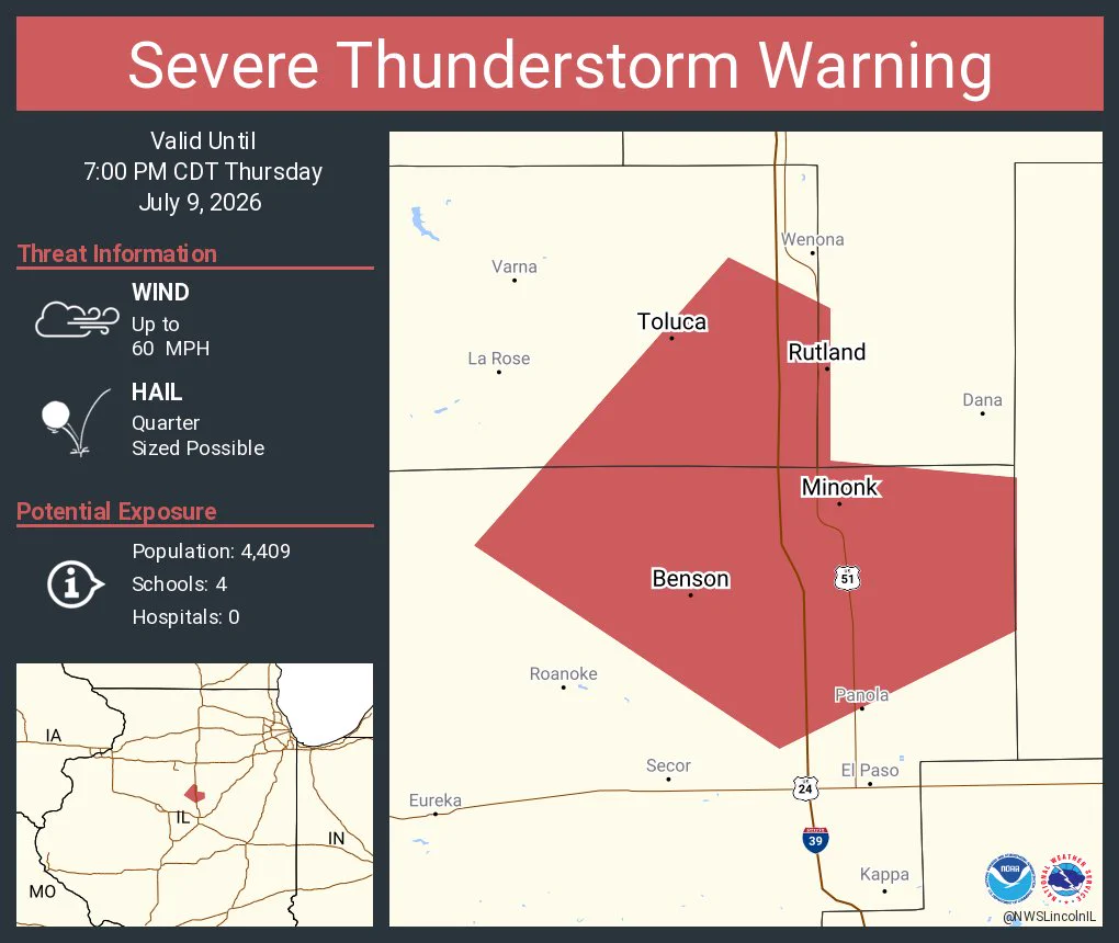
    Severe Thunderstorm Warning including Minonk IL, Toluca IL and Benson IL until 7:00 PM CDT
    This graphic displays a severe thunderstorm warning plotted on a map. The warning is in effect until 7:00 PM CDT. The warning includes Minonk IL, Toluca IL and Benson IL.  This warning is for Southeastern Marshall County in central Illinois and Northeastern Woodford County in central Illinois. The threats associated with this warning are wind gusts up to 60 MPH and quarter sized hail. There are 4,409 people in the warning along with 4 schools and 0 hospitals.
    1.2K
  • user avatar
    NWS Lincoln IL
    @NWSLincolnIL
    19h
    A special weather statement has been issued for Springfield IL, Sherman IL and Rochester IL until 6:00 PM CDT
    This graphic displays a special weather statement plotted on a map. The statement is in effect until 6:00 PM CDT.  The statement includes Springfield IL, Sherman IL and  Rochester IL.  A STRONG THUNDERSTORM WILL IMPACT NORTHEASTERN SANGAMON COUNTY THROUGH 600 PM CDT. The threats associated with this storm are wind gusts up to 50 MPH and no hail is expected. Seek shelter in a sturdy structure until the storm passes.
    1.4K
  • user avatar
    NWS Lincoln IL
    @NWSLincolnIL
    19h
    A special weather statement has been issued for Newton IL, Greenup IL and Toledo IL until 5:45 PM CDT
    This graphic displays a special weather statement plotted on a map. The statement is in effect until 5:45 PM CDT.  The statement includes Newton IL, Greenup IL and  Toledo IL.  A STRONG THUNDERSTORM WILL IMPACT SOUTH CENTRAL COLES, NORTHERN JASPER, SOUTHWESTERN CLARK and CUMBERLAND AND EAST CENTRAL EFFINGHAM COUNTIES THROUGH 545 PM CDT. The threats associated with this storm are wind gusts up to 50 MPH and no hail is expected. Seek shelter in a sturdy structure until the storm passes.
    1.1K
Advertisement
Advertisement