1. X
  2. NWS Climate Prediction Center
Log inSign up
NWS Climate Prediction Center
6,219 posts
Image
user avatar
NWS Climate Prediction Center
@NWSCPC
Official X account for the National Weather Service Climate Prediction Center. Details: weather.gov/nws_x
College Park, MD
cpc.ncep.noaa.gov
Joined June 2012
382
Following
65.7K
Followers
RepliesRepliesMediaMedia
  • user avatar
    NWS Climate Prediction Center
    @NWSCPC
    23h
    Key Message for Prolonged Southern U.S. Heat Wave and Rapid Onset Drought
     Key Message of extreme heat for much of the South-Central and Southeastern U.S. released August 10, 2026, for August 18-24.  a) The CPC Week-2 temperature outlook depicts large probabilities (greater than 70 percent chance) of above normal temperatures across the Southern Great Plains and Lower Mississippi Valley Aug 18 to 24. b) The risk of hazardous temperatures depicts a high risk (60 to 80 percent chance) of extreme heat across parts of the Central and Southern Great Plains, Middle and Lower Mississippi Valley, and Southeast. Moderate (40 to60 percent chance) and slight (20 to 40 percent chance) risks of extreme heat for a broader area of the south-central and southeastern U.S. and are valid from Aug 18 to 22 and Aug 18 to 24, respectively. A Rapid Onset Drought risk is posted for parts of the Southern Great Plains, Ozarks, and Lower Mississippi Valley.
  • user avatar
    NWS Climate Prediction Center
    @NWSCPC
    Aug 3
    An enhanced Southwest Monsoon is forecast next week as ridging across the West weakens and begins to shift farther east. As a result, there is an increased risk of heavy precipitation and flash flooding across portions of the Desert Southwest and Four Corners.
    An enhanced Southwest Monsoon is forecast next week as ridging across the West breaks down and begins to shift farther east. The Climate Prediction Center 8-14 day U.S. Hazards Outlook issued August 3, 2026 indicates a moderate risk (40 to 60 percent chance) of heavy precipitation, along with flooding possible, over portions of the Desert Southwest and Four Corners, August 11 to 14, 2026. A broader, slight risk (20 to 40 percent chance) of heavy precipitation is depicted over these areas, August 11 to 17.
  • user avatar
    NWS Climate Prediction Center
    @NWSCPC
    Jul 16
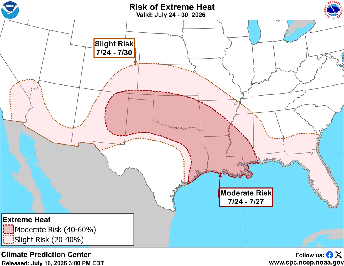
    Increased potential for extreme heat beginning late next week over parts of the southern U.S. A moderate risk includes the Southern Plains and Lower Mississippi Valley where triple digit temperatures are possible with heat index values upwards of 105-110 deg F.
    The risk of Extreme Heat from CPC issued July 16, 2026 depicts a moderate risk (40-60 percent chance) of extreme heat across parts of the Southern Plains and Lower Mississippi Valley, valid July 24 to July 27, where triple digit temperatures are possible with heat index values upwards of 105-110 deg F. A slight risk for extreme heat (20-40 percent chance) is posted across much of the southern CONUS from the Desert Southwest eastward through parts of the Central and Southern Plains, Middle and Lower Mississippi and Tennessee Valleys, and Southeast, valid July 24-30.
  • user avatar
    NWS Climate Prediction Center
    @NWSCPC
    Jul 14
    El Nino and the MJO favor a continued active East Pacific with significant chance of tropical cyclone (TC) development from July 22-28 and additional risk of TC formation from July 29-August 4. cpc.ncep.noaa.gov/products/preci…
    The Climate Prediction Center Global Tropics Hazards Outlook released July 14, 2026 for the valid period of July 22, 2026 through August 4, 2026. More than a 60 percent chance of tropical cyclone development is indicated for the Eastern Pacific from July 22 to 28; with a broader 40 to 60 percent chance and 20 to 40 percent chance. From July 29 to August 4, a 20 to 60 percent chance of tropical cyclone development is designated for the Eastern Pacific. This product is updated once per week and targets broad scale conditions integrated over a 7-day period for US interests only. This graphic does not indicate track or potential landfall of tropical systems. Refer to the National Hurricane Center (NHC) at www.nhc.noaa.gov.
  • user avatar
    NWS Climate Prediction Center
    @NWSCPC
    Jul 9
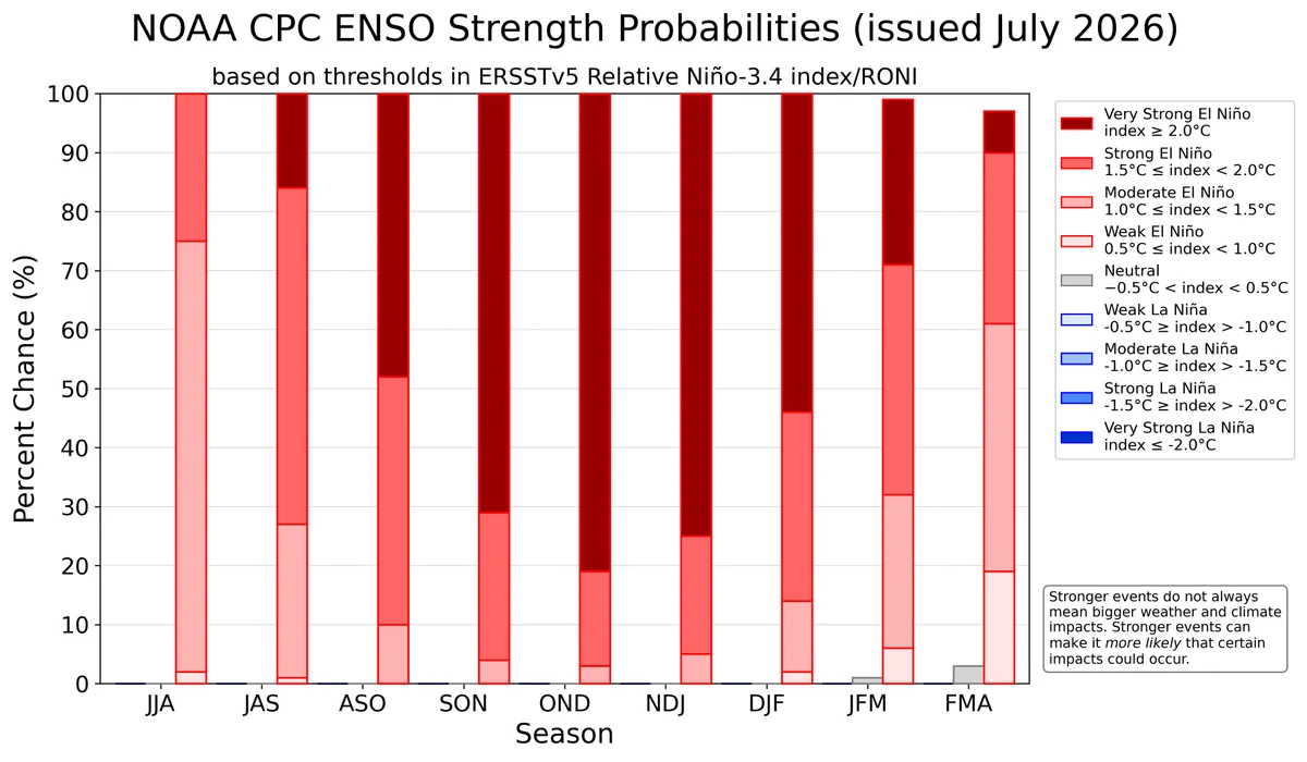
    El Niño continues and will strengthen through the end of the year, with a 97% chance it will persist through early spring 2027. An #ElNino Advisory remains in effect. #ENSO cpc.ncep.noaa.gov/products/analy…
    A bar chart showing the chance of El Niño (red bars), ENSO-Neutral (grey bars), and La Niña (blue bars) provided for 9 upcoming, overlapping 3-month seasons (each letter represents a month, for example, F = February). The color shading within the bars indicates the chances of different categories of El Niño or La Niña strength (weak, moderate, strong, and very strong). Alternatively, the table at the internet address below presents the percent chances of each strength category in numerical form. https://cpc.ncep.noaa.gov/products/analysis_monitoring/enso/roni/strengths/

Log in or sign up for X

See what’s happening and join the conversation

Continue with phone
or
Log in with username or email
Terms·Privacy·Cookies·Accessibility·Ads Info·© 2026 X Corp.
Advertisement
Advertisement