1. X
  2. Humanitarian Research Lab (HRL) at YSPH
Log inSign up
Humanitarian Research Lab (HRL) at YSPH
1,875 posts
Image
user avatar
Humanitarian Research Lab (HRL) at YSPH
@HRL_YaleSPH
Lab @YaleSPH, @YaleEMD researching and addressing humanitarian crises worldwide
New Haven, CT
ysph.yale.edu/hrl
Joined February 2022
699
Following
10.9K
Followers
RepliesRepliesMediaMedia

New to X?

Sign up now to get your own personalized timeline!

Create account

By signing up, you agree to the Terms of Service and Privacy Policy, including Cookie Use.

Terms·Privacy·Cookies·Accessibility·Ads Info·© 2026 X Corp.
Don't miss what's happening
People on X are the first to know.
Log inSign up
  • Pinned
    user avatar
    Humanitarian Research Lab (HRL) at YSPH
    @HRL_YaleSPH
    Jul 17
    🚨New Report 🚨 @HRL_YaleSPH corroborates reports of arson and other attacks on four communities in the Zaghawa area of North Darfur between 12 June and 7 July 2026. Three markets appear intentionally damaged in region experiencing severe malnutrition. #KeepEyesOnSudan
    Market, Um Baru Town, North Darfur
Conflict-related damage observed between 04 May-07 July 2026
Copyright: Satellite Imagery 04 May, 07 July 2026 © 2026 Vantor. Analysis conducted by Yale HRL.
Analysis of satellite imagery collected between 04 May and 07 July 2026 shows damage to several structures due to ground-based attacks in the market area of Um Baru.
    Map: Thermal Scarring at Communities near Umm Baru, North Darfur
Copyright: Map data ©OpenStreetMap contributors, Microsoft, Esri Community Maps contributors. Map layers by Esri. Analysis by Yale HRL.
Yale HRL assesses conflict-related damage consistent with arson attacks in at least four communities – Hazan Orschi, Quarbara, Um Baru, and Abu Leha – in Um Baru locality, North Darfur between 12 June and 7 July 2026. At least three markets have been visibly damaged in attacks.
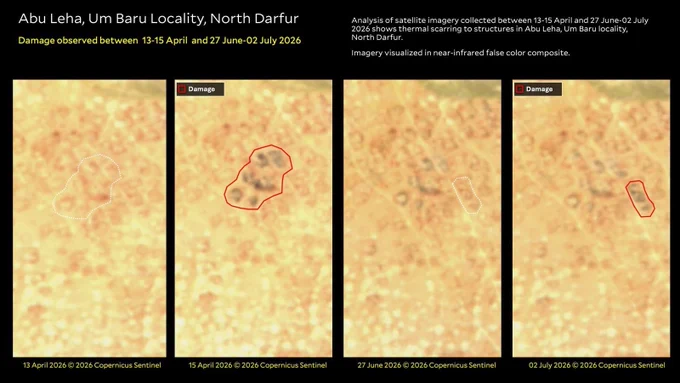
    Abu Leha, Umm Baru Locality, North Darfur
Damage Observed between 13-15 April and 27 June-02 July 2026.
Copyright: Satellite Imagery 13 April, 15 April, 27 June, 02 July 2026 © 2026 Copernicus Sentinel, analysis by Yale HRL.
Analysis of satellite imagery collected between 13-15 April and 27 June-02 July 2026 shows thermal scarring to structure in Abu Leha, Umm Baru locality, North Darfur. Imagery visualized in near-infrared false color composite.
    Market, Qarbara, North Darfur
Thermal scarring observed at market area between 22 June-07 July 2026.
Copyright: Satellite Imagery 22 June, 07 July 2026 © 2026 Copernicus Sentinel, analysis by Yale HRL.
Analysis of satellite imagery collected between 22 June and 07 July 2026 shows thermal scarring to a market in Qarbara, Umm Baru locality, North Darfur. Imagery visualized in near-infrared false color composite.
    19K019K
  • user avatar
    Humanitarian Research Lab (HRL) at YSPH
    @HRL_YaleSPH
    Oct 27, 2025
    🚨HUMAN SECURITY EMERGENCY🚨 El-Fasher has fallen to RSF. HRL finds evidence of mass killings including door-to-door clearance operations and objects consistent with reported bodies on berm entrapping El-Fasher. #KeepEyesOnSudan 🛰️@AirbusSpace @maxar medicine.yale.edu/lab/khoshnood/…
    Daraja Oula, El-Fasher 27 October 2025

Copyright: Satellite Imagery 27 October 2025 ©️Airbus DS 2025. Analysis conducted by Yale Humanitarian Research Lab

Clusters of objects and ground discoloration

13.6329010, 25.3271401

Imagery collected over the Daraja Oula neighborhood in El-Fasher on 27 October 2025 shows the presence of clusters of objects, ground discoloration, and light technical vehicles. The objects within these clusters measure between 1.5 meters – 2 meters in length. A group of light technical vehicles appear to be blocking the road near where what appears to be red discoloration on the ground. One cluster of objects is flanked by 3 light technical vehicles.
    Daraja Oula, El-Fasher27 October 2025

Cluster of objects consistent with the size of human bodies and reddish ground discoloration

Copyright: Satellite Imagery 27 October 2025 ©️Airbus DS 2025. Analysis conducted by Yale Humanitarian Research Lab

13.6325556, 25.3259461 

In imagery collected  over Darja Oula on 27 October 2025, the presence of clusters of light and dark colored objects consistent with the size of human bodies, reddish ground discoloration, and vehicles are  visible. These observations are not seen in prior satellite imagery.
    Daraja Oula, El-Fasher 27 October 2025

Reddish ground discoloration and vehicle presence

Copyright: Satellite Imagery 27 October 2025 ©️Airbus DS 2025. Analysis conducted by Yale Humanitarian Research Lab

13.6324204, 25.3282774 

In imagery collected over Daraja Oula on 27 October 2025, two reddish ground discolorations are visible that are not seen in prior satellite imagery. Multiple vehicles are present in the same area, which appears consistent with door-to-door clearance operations.
    157th Artillery Brigade, El-Fasher 27 October 2025

Clusters of objects and ground discoloration

Copyright: Satellite Imagery 27 October 2025 ©️Airbus DS 2025. Analysis conducted by Yale Humanitarian Research Lab

13.6365946, 25.3109425

In imagery collected over the 157th Artillery Brigade in El-Fasher on 27 October 2025 shows the presence of clusters of objects along the defensive berm. These objects are not visible in imagery collected on 26 October 2025 and the appearance of these objects coincides with reports that civilians were shot attempting to flee El-Fasher over the berm.
    2.4M02.4M
  • user avatar
    Humanitarian Research Lab (HRL) at YSPH
    @HRL_YaleSPH
    Nov 1, 2025
    🚨ATROCITY ALERT 🚨 1) Most remaining civilians have not fled El Fasher - likely trapped or dead 2) RSF continues mass killings 3) Displaced people visible in Garni, location of reported gross human rights abuses. #KeepEyesOnSudan 🛰️@vantortech @AirbusDS medicine.yale.edu/lab/khoshnood/…
    University of El-Fasher, El-Fasher 28 October 2025

New clusters of objects and ground discoloration

Copyright: 28 October 2025 ©️Airbus DS 2025; Analysis conducted by Yale HRL.

13.6284615, 25.3275711
 
Imagery collected over the University of El-Fasher on 28 October 2025 shows the presence of clusters of objects and reddish ground discoloration. The objects in these clusters range between 1.2-1.8 meters in length. These objects are not visible in imagery collected on 26 October 2025 and the appearance of these objects coincides with reports that civilians were being killed en masse within the Faculty of Medical Laboratory Science compound.
    Northern Berm, El-Fasher
Thermal scarring and burnt remains 15-30 October 2025
13.713424,25.278568

Copyright: Satellite Imagery 15, 31 October 2025 ©️2025 Vantor; Analysis Conducted by Yale HRL.

Analysis of satellite imagery collected on 30 October 2025 on the northern berm around El-Fasher shows new thermal scarring, at least 20 destroyed vehicles, and objects measuring 1.2-2 meters in length. Geolocation of ground footage confirms that these objects are bodies. Analysis of low-resolution Sentinel imagery shows this occurring between 24-27 October.
    Daraja Oula Neighborhood, El-Fasher 28 October 2025

New clusters of objects and ground discoloration

13.6312463, 25.3272625

Copyright: Satellite Imagery 26 October 2025 ©️Vantor, 2025; 28 Oct 2025 ©️Airbus DS 2025; Analysis conducted by Yale HRL.

(Yellow dotted boxes denote cluster of objects and ground discoloration previously reported on by Yale HRL on 27 October 2025)

Imagery collected over the Daraja Oula neighborhood of El-Fasher on 28 October 2025 shows clusters of objects and reddish ground discoloration. The objects in these clusters range between 1.2-1.8 meters in length. These objects are not visible in imagery collected on 26 October 2025 and the appearance of these objects coincides with reports that civilians were being killed in door-to-door house clearing operations by the RSF.
    Garni, North Darfur
Increase in temporary structures 26 September-30 October 2025
13.740245,25.231418

Copyright: Satellite Imagery 26, 31 October 2025 ©️2025 Vantor. Analysis Conducted by Yale HRL.

Analysis of satellite imagery collected on 30 October in the village of Garni roughly 14 km northwest of El-Fasher shows presence of new temporary structures. Analysis of lower resolution satellite imagery narrows down the appearance of these structures to 23-30 October 2025. These structures measure approximately 2 by 3 meters.
    383K0383K
  • user avatar
    Humanitarian Research Lab (HRL) at YSPH
    @HRL_YaleSPH
    Oct 29, 2025
    🚨HUMAN SECURITY EMERGENCY🚨 Day 2: RSF continues mass killings in El Fasher: @HRL_YaleSPH finds evidence of mass killings at RSF-controlled former Children’s Hospital, Saudi Hospital and along the berm. #KeepEyesOnSudan 🛰️@AirbusSpace @maxar medicine.yale.edu/lab/khoshnood/…
    Former Children’s Hospital, El-Fasher

Crowding and object disposal observed between 26-27 October 2025 and 28 October 2025

12.079599, 24.960337

Copyright: Satellite Imagery 26 October 2025 ©️2025 Vantor; 27, 28 October 2025 ©️Airbus DS 2025. Analysis conducted by Yale HRL.

In satellite imagery collected on 27 October 2025, clusters of dark colored objects consistent with people create a large queue outside the former Children's Hospital, stretching from the building to the gate of the compound. Across the street, a new cluster of white objects appear that are not seen in prior imagery collected on 26 October.

In imagery collected on 28 October 2025, dark colored objects of a similar size and color as the queue seen in previous imagery now appear tightly grouped together. In the same image, a new set of light-colored objects appears in the southeast corner of the compound. Across the street, the object cluster appears to grow in number.
    Al-Saudi Hospital, El-Fasher
Light-colored objects Observed on 28 October 2025

Copyright: Satellite Imagery 28 October 2025 ©️Airbus DS 2025; Analysis Conducted by Yale HRL.

Analysis of satellite imagery collected on 28 October 2025 of the Al-Saudi Hospital in the Daraja Oula neighborhood of El-Fasher shows at least four new clusters of light-colored objects that were not visible in prior imagery. Some white colored objects measure approximately 1.1-1.9 meters, although some objects appear more homogenous in color, making size measurement difficult. The light-colored objects in group C appear with reddish discoloration of the ground nearby.
    El-Fasher 27 October 2025

Technical vehicles, clusters of objects, and ground discoloration

13.6474933, 25.3081181

Copyright: Satellite Imagery 27 October 2025 ©️Airbus DS 2025; Analysis Conducted by Yale HRL.

Blue Dots Symbolize Cluster of objects previously reported on by Yale HRL on 27 Oct 2025

Red Dots Symbolize Cluster of objects reported by Yale HRL on 28 Oct 2025

Imagery collected over the west of El-Fasher on 27 October 2025 shows clusters of objects along the city’s encircling berm following a path heading north. These objects are not visible in imagery collected on 26 October 2025 and the appearance of these objects coincides with reports that civilians were chased with vehicles and shot while attempting to flee El-Fasher.
    El-Fasher, West of Former UNAMID Compound
Light technical vehicles and clusters of objects observed 26-27 & 28 October 2025

Copyright: 25 October 2025 ©️2025 Vantor; 27, 28 October 2025 ©️Airbus DS 2025. Analysis Conducted by Yale HRL.

Analysis of satellite imagery collected initially between 25 and 27  October 2025 shows the new presence of three light technical vehicles and two clusters of objects next to these vehicles. One cluster of objects is surrounded by a reddish ground discoloration.

Further analysis of imagery collected 28 October 2025 of this location shows the same cluster of objects remain with the light technical vehicles no longer present.
    122K0122K
  • user avatar
    Humanitarian Research Lab (HRL) at YSPH
    @HRL_YaleSPH
    Oct 28, 2025
    Replying to @HRL_YaleSPH
    HRL IDed groups in 🛰️ imagery moving from El-Fasher toward RSF-controlled Zamzam IDP Camp + west toward Tawilah. The international community received hundreds of warnings about likely atrocities upon the fall of El-Fasher to RSF #KeepEyesOnSudan 🛰️@AirbusSpace @maxar
    6th Division HQ, El-Fasher26 October 2025

Munition impacts, thermal scarring, and confirmation of RSF presence.

Copyright: Satellite Imagery 27 October 2025 ©️2025 Vantor. Analysis conducted by Yale Humanitarian Research Lab

13.6283278, 25.3497824

Yellow encircles Thermal scarring
Red boxes outline Munition impacts

In imagery collected over the 6th Division Headquarters in El-Fasher on 26 October 2025 shows the presence of at least 15 new munition impacts and thermal scarring in and around the headquarters since imagery collected on 15 October.

Geolocation by Yale HRL corroborates the presence of RSF soldiers in the area as well as a T55 tank driving past the headquarters.
    157th Artillery Brigade, El-Fasher27 October 2025

Presence of tanks and light technical vehicles13.6248554, 25.3127202

Copyright: Satellite Imagery 27 October 2025 ©️Airbus DS 2025. Analysis conducted by Yale Humanitarian Research Lab

Imagery collected over the 157th Artillery Brigade in El-Fasher on 27 October 2025 shows the presence of two objects consistent with tanks, one likely being a T55, not previously visible in imagery collected on 26 October 2025. Videos posted to social media show a tank consistent with a T55 driving past the 6th Division Headquarters.
    108K0108K
  • user avatar
    Humanitarian Research Lab (HRL) at YSPH
    @HRL_YaleSPH
    Nov 14, 2025
    🚨ATROCITY ALERT🚨 @HRL_YaleSPH has identified four new locations where the RSF is disposing of bodies in and around El Fasher. #KeepEyesonSudan 🛰️@vantortech medicine.yale.edu/lab/khoshnood/…
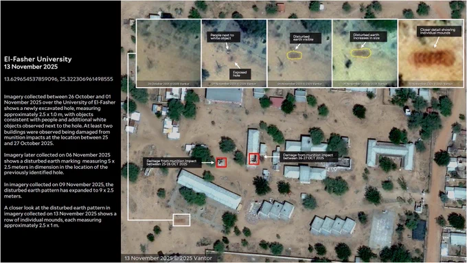
    El-Fasher University
13 November 2025

13.629654537859096, 25.322306961498555


Imagery collected between 26 October and 01 November 2025 over the University of El-Fasher shows a newly excavated hole, measuring approximately 2.5 x 1.0 m, with objects consistent with people and additional white objects observed next to the hole. At least two buildings were observed being damaged from munition impacts at the location between 25 and 27 October 2025.

Imagery later collected on 06 November 2025 shows a disturbed earth marking  measuring 5 x 2.5 meters in dimension in the location of the previously identified hole.

In imagery collected on 09 November 2025, the disturbed earth pattern has expanded to 9 x 2.5 meters.

A closer look at the disturbed earth pattern in imagery collected on 13 November 2025 shows a row of individual mounds, each measuring approximately 2.5 x 1 m.
    Abu Shouk IDP Camp
Repeated Body Disposal Activity in Disturbed Earth, 25 October - 7 November 2025

Analysis of satellite imagery shows a new excavated hole measuring approximately 8 x 3 meters behind a building in the Abu Shouk IDP Camp between 15 and 25 October 2025. Also visible on 25 October is a group of white objects next to the hole, as well as white objects observed on the eastern side of the building. 
On 04 November 2025, the white objects previously observed are no longer visible; a white object is visible in the hole. By 06 November 2025, the white object in the hole is not visible and a white reflective object or objects is apparent next to the hole. 
Imagery collected on 07 November 2025 shows more white objects in the hole, while white objects are visible next to the hole.
By 13 November 2025, the white objects next to the hole are no longer visible; however, non-reflective objects partially covered in dirt are visible within the hole. | 13.664123,25.335797
    Saudi Hospital, El-Fasher
Burning of White Objects Observed between 30 October - 13 November 2025

13.629331, 25.329449

Analysis of satellite imagery collected between 30 October and 01 November 2025 over the southside of Saudi Hospital shows a cluster of white objects newly present in an exposed, recessed earth disturbance.
Imagery collected on 06 November 2025 shows the objects actively burning, with black smoke emanating from the site. 
07 November 2025, imagery shows no active burning and the presence of new white objects. By 12 November 2025, there appears to be an increase in white objects.
Imagery collected on 13 November 2025 shows thermal scarring and ash in the location where the white objects were previously observed on 12 November 2025.
    Daraja Oula, El-Fasher
Body Disposal Activity Observed between 26 October and 1 November 2025

13.639075,25.327812

Analysis of satellite imagery collected on 1 November 2025 in Daraja Oula shows white objects at a site that was previously destroyed due to likely bombardment in May 2025. The white objects measuring approximately 0.75-1.25 meters are newly present in satellite imagery between 26 October  and 1 November 2025 are no longer visible in satellite imagery on 02 November 2025, and dark colored objects measuring approximately 1 meter appear in imagery collected on 13 November.
    119K0119K
  • user avatar
    Humanitarian Research Lab (HRL) at YSPH
    @HRL_YaleSPH
    Nov 7, 2025
    🚨ATROCITY ALERT 🚨 RSF has closed 1 of only 5 exits out of El-Fasher. @HRL_YaleSPH identifies ongoing possible body disposal activities in and around El Fasher #KeepEyesOnSudan 🛰️@vantortech medicine.yale.edu/lab/khoshnood/…
    Garni Gate, El-Fasher
Berm Access Closure Observed between 02-04 November 2025
13.707883, 25.257496

Copyright: Satellite Imagery 02, 04 November 2025 © 2025 Vantor. Analysis conducted by Yale Humanitarian Research Lab.

Analysis of imagery collected between 02 and 04 November 2025 shows that the western access checkpoint in the berm surrounding El-Fasher has had its entry and exit points to the city closed by means of new earthen berm constructions. 
This now-closed access point is situated on a road leading to the village of Garni, North Darfur.
    Saudi Hospital, El-Fasher
Burning objects observed on 06 November 2025
13.629331, 25.329449


Copyright: Satellite Imagery 31 October, 01. 06 November 2025 © 2025 Vantor. Analysis conducted by Yale Humanitarian Research Lab.

Analysis of satellite imagery initially collected between 31 October and 01 November 2025 over the southside of Saudi Hospital in El-Fasher shows the new presence of a grouping or cluster of white oblong objects near the main building of the hospital.
Imagery later collected on 06 November 2025 shows the cluster of objects are visibly charred and emitting black smoke, indicative of the cluster actively burning in the imagery.

Additionally observed in 06 November imagery is the new presence of a white closed-back panel truck or SUV parked behind the main building, and a white pickup truck parked roadside outside of the southside entrance of the hospital.
    Mellit Gate,  El-Fasher

Burning objects Observed on 06 November 2025

Copyright: Satellite Imagery 31 October, 01, 06 November 2025 © 2025 Vantor. Analysis conducted by Yale Humanitarian Research Lab.

Analysis of satellite imagery initially collected between 25 and 30 Oct 2025 of the Mellit Gate, the northern checkpoint in the berm surrounding El-Fasher, shows on 10/30/25, a  new presence of objects and material placed within the trench of a berm on the southern side checkpoint. Additionally, approximately 15 light technical vehicles are observed gathered next to the dumping site at the trench. 

Previous imagery of this location collected 10/25/25 shows several camels on both northern and southern sides of the berm making passage at the checkpoint. The objects and material remain visible in the trench in imagery collected 11/1/25.

Imagery collected 11/6/25 shows the objects and material visibly charred and emitting black smoke, indicative of them actively burning in the imagery.
    El-Fasher to Kutum Road, El-Fasher
Light-Colored Objects Observed Between 03-04 November 2025
13.718841,25.278346

Copyright: Satellite Imagery 03, 04 November 2025 © 2025 Vantor. Analysis conducted by Yale Humanitarian Research Lab.

Analysis of satellite imagery collected between 03-04 November over the Kutum-to-El-Fasher Road, approximately 5.4 km southeast of Garni, show light-colored objects that approximately measure 1.1-1.6 meters newly present in imagery collected on 04 November that were not present in prior imagery. These objects are present in imagery collected through at least 6 November 2025.
    134K0134K
  • user avatar
    Humanitarian Research Lab (HRL) at YSPH
    @HRL_YaleSPH
    Nov 5, 2025
    🚨ATROCITY ALERT🚨 @HRL_YaleSPH identifies body disposal including 2 mass graves and ongoing mass killing in RSF-controlled El-Fasher. A checkpoint on Tawila road shows people grouped, possibly detained IDPs. 🛰️@vantortech/@AirbusDS medicine.yale.edu/lab/khoshnood/…
    Former Children’s Hospital, El-Fasher
New Disturbed Earth, dark colored objects, thermal scarring Observed Between 28 October & 01-02 November 2025

Copyright: Satellite Imagery 30 October 2025 ©️Airbus DS 2025; 01 November 2025 ©️2025 Vantor. Analysis Conducted by Yale HRL

Analysis of satellite imagery collected on 01-02 November 2025 of the former Children’s Hospital in El-Fasher shows new dark colored objects measuring approximately 1.3-2 meters in length, new thermal scarring where a cluster of objects was previously identified, and disturbed earth measuring 15 x 14 meters appears that is not previously seen in prior imagery from 28 October 2025. Imagery collected on 02 November 2025 shows an open trench within the plot of disturbed earth; it appears covered in imagery collected on 03 November 2025. | 13.621739,25.383059
    Former Children’s Hospital, El-Fasher 
26 October-03 November 2025

Copyright: Satellite Imagery 26 October 2025, 1, 2, 3 November 2025©️2025 Vantor. Analysis Conducted by Yale HRL

New disturbed earth, light colored objects, and trenching observed

13.621765,25.383252 
         
Imagery collected over the former Children’s Hospital shows the appearance of new disturbed earth between 26 October-01 November.  Imagery collected on 02 November shows additional disturbed earth, including the presence of a new trench measuring 7 x 4 meters. Imagery collected on 03 November 2025 shows the trench is no longer visible, along with two light colored objects measuring 1.3 and 2 meters in length appearing in a hole above the prior trenching.
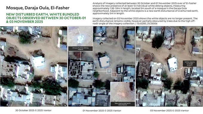
    Mosque, Daraja Oula, El-Fasher
New disturbed earth, white bundled objects Observed between 30 October-01 & 03 November 2025

Copyright: Satellite Imagery 30 October 2025, 1, 3 November 2025©️2025 Vantor. Analysis Conducted by Yale HRL

Analysis of imagery collected between 30 October and 01 November 2025 over of El-Fasher shows the new presence of at least 12 individual white oblong objects, measuring approximately 1.38-1.8m in length, located 5m south of a mosque in the Daraja Oula neighborhood. Adjacent to the white objects is a new earth disturbance of overturned earth, approximately 5m in length.  

Imagery collected on 03 November 2025 shows the white objects are no longer present. The earth disturbance remains visible, however partially obscured by trees due to the high off-nadir angle of the imagery collection. | 13.63283, 25.33006
    A5 Road, East of Tawilah
Checkpoint Activity Observed between 30 October-01 November 2025

Copyright: Satellite Imagery 30 October 2025, 1 November 2025©️2025 Vantor. Analysis Conducted by Yale HRL

Analysis of imagery collected between 30 October and 01 November 2025 shows the new presence of a checkpoint on the A5 road, located 20km east of Tawilah. Newly present is a post, likely an erected covering or tent positioned on the roadside with a light technical vehicle positioned 12 m behind it. A weapon mounted light technical vehicle with a grouping of objects consistent with people gathered nearby is observed 60m south of the checkpoint post.

Another weapon-mounted light technical vehicle is observed skirting the checkpoint on a short side-path parallel to the A5. | 13.58612, 25.07217
    151K0151K
  • user avatar
    Humanitarian Research Lab (HRL) at YSPH
    @HRL_YaleSPH
    Feb 14, 2023
    !NEW REPORT!: Russia has held more than 6,000 children from Ukraine in 43+ camps and other facilities for systematic re-education, and in some cases foster/adoption from Black Sea to Russia’s Far East finds @HRL_YaleSPH in @ObserveConflict @StateCSO childrencamps.conflictobservatory.org
    Image
    Image
    150K0150K
  • user avatar
    Humanitarian Research Lab (HRL) at YSPH
    @HRL_YaleSPH
    Sep 29, 2025
    🚨EMERGENCY ALERT 🚨 RSF preparing large-scale drone attack as of THIS MORNING, 08:47:36 UTC/10:47:36 local, 29 September 2025. All of Sudan is in range. 🛰️ @maxar #KeepEyesOnSudan medicine.yale.edu/lab/khoshnood/…
    Nyala Airport | 29 September 2025
UAVs and Launchers Observed
Copyright: Satellite Imagery 26, 29 September 2025 © 2025 Maxar Technologies. Analysis conducted by Yale HRL

Imagery collected between 26 and 29 September 2025 over Nyala airport shows the new presence of 43 UAVs, the majority of which are consistent with fixed-wing loitering munitions based on the Shahed-136 delta-wing design.

At least 36 objects consistent with launchers for the UAVs are also visible on 29 September 2025; an increase of 20 from the previously observed 16 launchers on 26 September 2025.
    244K0244K
  • user avatar
    Humanitarian Research Lab (HRL) at YSPH
    @HRL_YaleSPH
    Jun 13, 2024
    BREAKING: @YaleHRL identifies cargo aircraft flying over RSF territory in El-Fasher matching plane seen at UAE base in Chad that allegedly provides lethal aid to RSF. medicine.yale.edu/lab/khoshnood/… 1/ 🛰️ : @maxar
    Ilyushin Il-76 observed in flight over RSF territory east of El-Fasher

Satellite Imagery: 11 June 2024 | 11:08 UTC+2, 11 June 2024 | 11:09 UTC+2, © 2024 Maxar, USG-Plus. Analysis by the Yale Humanitarian Research Lab.

According to analysis of satellite imagery, on 11 June 2024, an Ilyushin Il-76 cargo plane was observed flying over RSF territory at approximately 11:08 UTC+2. Imagery collected approximately one minute later at 11:09 UTC+2 shows the Il-76 in flight approximately 12 km northeast of the previously observed location.
    171K0171K
  • user avatar
    Humanitarian Research Lab (HRL) at YSPH
    @HRL_YaleSPH
    Jan 16, 2025
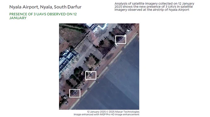
    🚨Breaking🚨: @HRL_YaleSPH has observed 3 UAVs at RSF-controlled Nyala Airport between 9 Dec 2024 - 14 Jan 2025. These UAVs are consistent with FH-95s (Feihong). Yale corroborates reports of recent cargo flights supplying RSF at Nyala. 🛰️@maxar @planet medicine.yale.edu/lab/khoshnood/…
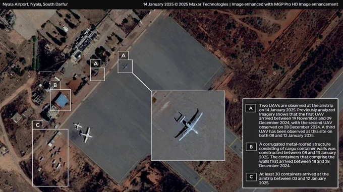
    Title: Nyala Airport, Nyala, South Darfur 
Copyright: 14 January 2025 © 2025 Maxar Technologies | Image enhanced with MGP Pro HD image enhancement, Analysis by Yale HRL.
Text: (A) Two UAVs are observed at the airstrip on 14 January 2025. Previously analyzed imagery shows that the first UAV arrived between 19 November and 09 December 2024, with the second UAV observed on 28 December 2024. A third UAV has been observed at this site on both 08 and 12 January 2025. 
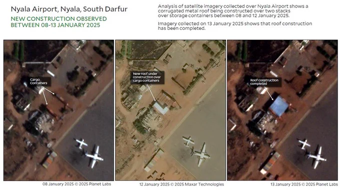
(B) A corrugated metal-roofed structure consisting of cargo container walls was constructed between 08 and 13 January 2025. The containers that comprise the walls first arrived between 18 and 28 December 2024. 
(C) At least 30 containers arrived at the airstrip between 03 and 12 January 2025.
    Title: Nyala Airport, Nyala, South Darfur
Subtitle: Presence of 3 UAVs observed on 12 January
Copyright: 12 January 2025 © 2025 Maxar Technologies, Image enhanced with MGP Pro HD image enhancement
    Title: Nyala Airport, Nyala, South Darfur
Subtitle: New Construction observed between 08-13 January 2025 
Copyright: 08 January 2025 © 2025 Planet Labs; 12 January 2025 © 2025 Maxar Technologies, 13 January 2025 © 2025 Planet Labs, Analysis by Yale HRL.
Text: Analysis of satellite imagery collected over Nyala Airport shows a corrugated metal roof being constructed over two stacks over storage containers between 08 and 12 January 2025. 
 Imagery collected on 13 January 2025 shows that roof construction has been completed.
    171K0171K
  • user avatar
    Humanitarian Research Lab (HRL) at YSPH
    @HRL_YaleSPH
    Aug 28, 2025
    RSF completed 31+ km of berms walling in El-Fasher, w/ total control of population flow into/out of the city. RSF has created a literal kill box. Damage IDed to the El-Fasher Water Provision Authority threatens precarious health conditions 🛰️ @Maxar medicine.yale.edu/lab/khoshnood/…
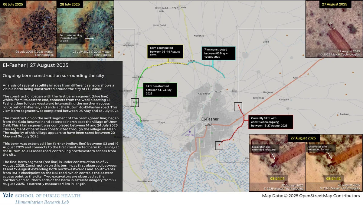
    El-Fasher | 27 August 2025

Ongoing berm construction surrounding the city

Copyright: Satellite Imagery 06 July 2025, 28 July 2025, 27 August 2025 © 2025 Maxar Technologies; Map Data:© 2025 OpenStreetMap Contributors; Analysis conducted by Yale HRL

Map shows the city of El-Fasher with two semi-circle segments with different colors surrounding at least 2/3 of a ring around El-Fasher.

Analysis of several satellite images from different sensors shows a visible berm being constructed around the city of El-Fasher.

The construction began with the first berm segment (blue line) which, from its eastern end, connects from the wadi bisecting El-Fasher, then follows westward intersecting the northern access route out of El-Fasher, and ends at the Kutum-to-El-Fasher road. This 7 km berm segment was completed between 05 May and 12 July 2025.
    113K0113K
  • user avatar
    Humanitarian Research Lab (HRL) at YSPH
    @HRL_YaleSPH
    Nov 4, 2024
    🚨BREAKING: @HRL_YaleSPH corroborates alleged mass killings of civilians in Gezira by RSF through satellite imagery analysis. Body disposal, large-scale burials at cemeteries, & presence of looting visible at Tamboul, Rufaa, & Al-Sariha. 🛰️ @planet @maxar medicine.yale.edu/lab/khoshnood/…
    Title: Cemetery (1), Rufaa, Gezira

Subtitle: GRAVE INCREASE OBSERVED BETWEEN 05 JULY -31 OCTOBER 2024

Copyright: 05 July © 2024 Maxar, USG-Plus, 31 October 2024 © 2024 Planet Labs, Analysis by Yale HRL.

Text: Analysis of satellite imagery of a cemetery in Rufaa shows an increase of approximately 80 mounds between 05 July and 31 October 2024. This is a significantly rapid rate of increase for this timeframe compared to archival imagery of this grave site.
    Title: Cemetery (2), Rufaa, Gezira

Subtitle: GRAVE INCREASE OBSERVED BETWEEN 29 SEPTEMBER-31 OCTOBER 2024

Copyright: 29 September © 2024 Maxar, USG-Plus, 31 October 2024 © 2024 Planet Labs, Analysis by Yale HRL.

Text: Analysis of satellite imagery of a cemetery in Rufaa shows its area had increased from a total area of approximately 660 square meters to approximately 1,000 square meters, an increase of 52% between 29 September-31 October 2024. Also observed in 31 October imagery are several light color-reflective objects near the grave mounds, likely indicative of ongoing activity relating to excavations or burials. This growth is a significantly rapid rate of increase for this timeframe compared to archival imagery of this grave site.
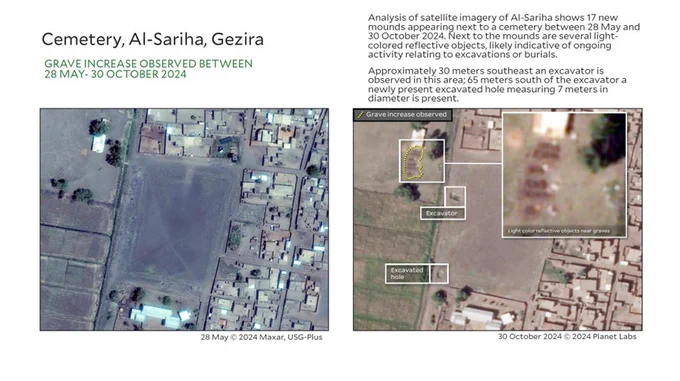
    Title: Cemetery, Al-Sariha, Gezira

Subtitle: GRAVE INCREASE OBSERVED BETWEEN 28 MAY- 30 OCTOBER 2024

Copyright: 28 May © 2024 Maxar, USG-Plus, 30 October 2024 © 2024 Planet Labs, Analysis by Yale HRL.

Text: Analysis of satellite imagery of Al-Sariha shows 17 new mounds appearing next to a cemetery between 28 May and 30 October 2024. Next to the mounds are several lightcolored reflective objects, likely indicative of ongoing activity relating to excavations or burials. Approximately 30 meters southeast an excavator is observed in this area; 65 meters south of the excavator a newly present excavated hole measuring 7 meters in diameter is present.
    Title: Police station, Tamboul, Gezira

Subtitle: OBJECTS OBSERVED BETWEEN 29 SEPTEMBER-31 OCTOBER 2024

Copyright: 29 September 2024 © 2024 Maxar, USG-Plus 31 October 2024 © 2024 Planet Labs, Analysis by Yale HRL.

Text: Analysis of satellite imagery collected between 29 September and 31 October 2024 shows light-colored reflective bundles or objects averaging in size to 2.0m long and 0.9m wide on the grounds of the police station in Tamboul, Gezira.
    69K069K
Advertisement
Advertisement